|
|
Depth to the Moho discontinuity in the eastern part of the Russian Arctic zone
The Mohorovicic (Moho) discontinuity is one of the most important boundaries within the Earth, which
is characterized by strong changes of all physical parameters [Rabbel et al., 2013].
Therefore, the knowledge on the Moho depths is extremely important for various geophysical models
and for understanding of the lithosphere structure and dynamics.
Direct data on the Moho depth can be only obtained from seismic studies, which coverage is extremely
heterogeneous. In particularly, the seismic determinations are almost not available in the eastern part
of the Russian Arctic zone, which is and extremely hard-accessible area [Petrov et al., 2016].
The new Moho map has been recently obtained for this region (60–75° N, 110–190° E) by Kaban et al. (2022).
This area is unique in its structure, as it includes several tectonic elements of different age — from Paleozoic
to Early Cenozoic [Petrov, Smelror, 2021]. The Moho map is based on a joint inversion of various
geophysical fields, primarily, the residual gravity field and vertical gravity gradients.
The initial map of Petrov et al. (2016) has been corrected to fit these fields with additional
constraints from several seismic profiles.
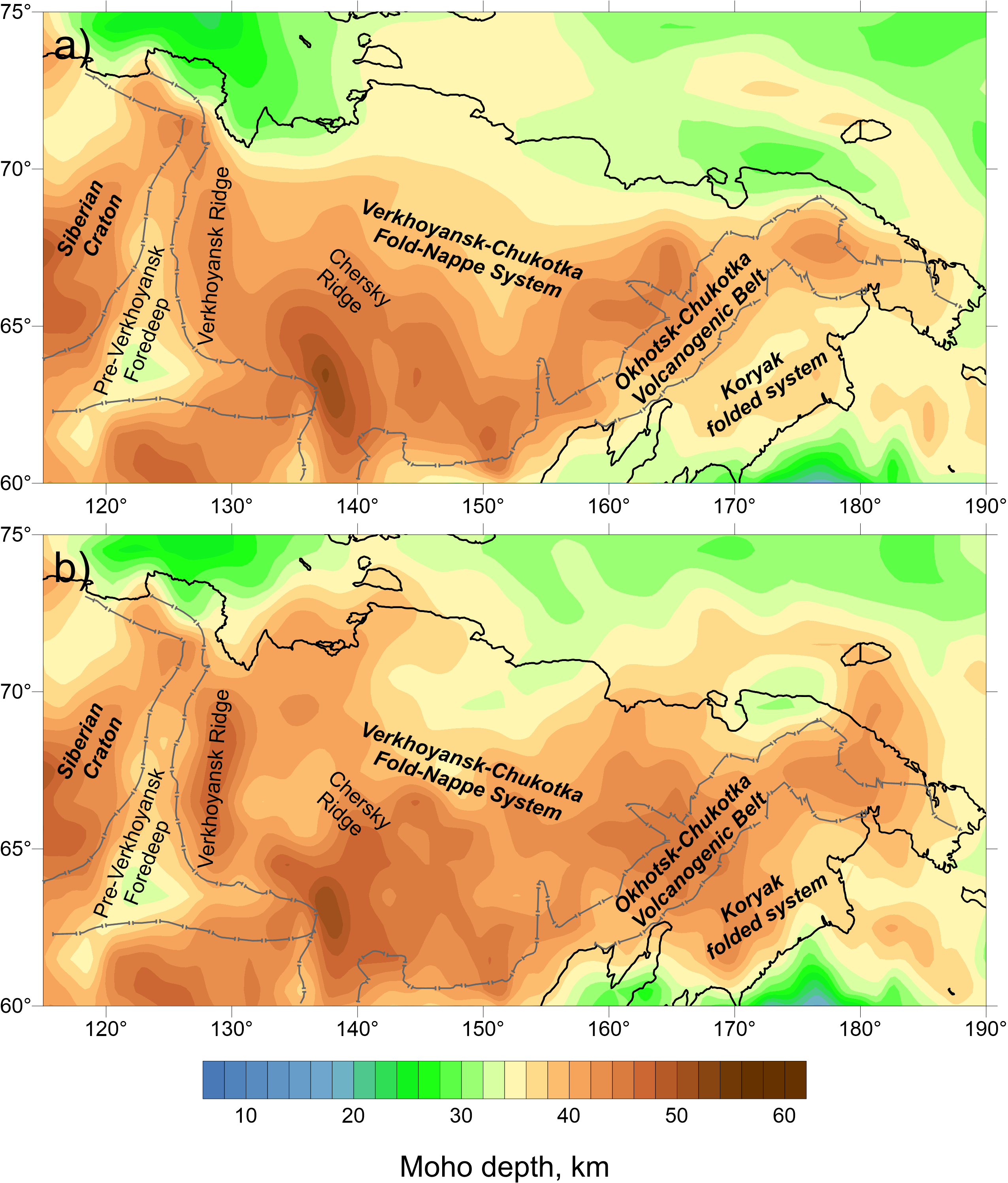
The new Moho depth model (Fig. 1b) was compared in details with the initial model of Petrov et al. (2016)
(Fig. 1a). The new model shows some principal features which were absent before:
- In the new model, there is a 47 km deep lithospheric root beneath the Verkhoyansk Ridge compared to
the relatively small Moho depression in the initial model. Such a thickening of the Earth's crust is characteristic
of mountain ranges, which confirms the reliability of the model obtained.
- A significant difference was obtained in the Moho depth (from 25–40 to 38–45 km) in the northern
continental part of the study area and on the shelf. We suggest that this thickening of the Earth's crust is
related to underplating due to plume activity that took place earlier.
- The offshore area of the Chukotka microcontinent in the new model is characterized by a crustal
thickness of 38–42 km at the margin of the Verkhoyansk-Chukotka fold belt and 42–44 km under the Chukotka Peninsula.
The zone of relatively thin (26–28 km) crust underlying the Chukchi Sea turned out to be less extended than
in the original model. On the other hand, the maximum Moho depth (42 km) under the Okhotsk-Chukotka volcanogenic
belt has not changed in the new model.
- The thickness of the earth's crust under the location of the Anadyr-Koryak fold system has increased to 10 km.
This corresponds to the general ideas about the development of this fold system [Sokolov, 1982;
Tsukanov, Lobkovsky, 2020].

Figure 1.
Initial Moho depth map (a) and the corrected Moho map (b), showing depths from the sea level
The model was also compared with the ArcCrust model [Lebedeva-Ivanova et al., 2019]
based on a 3D gravity inversion constrained by other geophysical data. The ArcCrust model provides much less details
compared to our map in the continental part, in particular, for the maximum associated with the northern part
of the Verkhoyansk Range. In general, the ArcCrust model gives more thick crust for the northern part of the study area,
which is probably due to insufficient resolution of the initial data.
As the new Moho model perfectly fits the tectonic fragmentation of the study area and main stages of its
development, it can be considered as an essential improvement of previous models for the Russian Arctic zone.
The dataset includes the data spreadsheet obtained as a result of the Moho discontinuity modeling using
the above mentioned complex of geophysical data. The data are
freely accessible.
The study area spans from 60° to 75°N and from 110° to 190°E, covering the north-eastern
Eurasia including the Eastern Russian Arctic segment. The data values in km, with a spatial resolution of 1°x1°,
are referenced to geographic coordinates, where longitude spans eastward (179–170°W longitudes are denoted as 181–190°E for convenience).
Data is have the following designations: mw21-vs-cor.dat — Moho depth data file,
moho_format.pdf — data format description.
References
Filatova, N. I., Khain, V.E. (2008). Development of the Verkhoyansk–Kolyma orogenic
system as a result of interaction of adjacent continental and oceanic plates.
Geotectonics, 42, 258. https://doi.org/10.1134/S001685210804002X.
Kaban, M. K., Sidorov, R. V., Soloviev, A. A., Gvishiani, A. D., Petrunin, A. G.,
Petrov, O. V., Sergey N. Kashubin, Evgeniy A. Androsov, and Milshtein, E. D. (2022).
A New Moho Map for North-Eastern Eurasia Based on the Analysis of Various Geophysical Data.
Pure and Applied Geophysics, 1-14, https://doi.org/10.1007/s00024-021-02925-6.
Kashubin, S. N., Pavlenkova, N. I., Petrov, O. V., Milshtein, E. D., Shokalsky, S. P.
and Erinchek, Yu. M. (2013) Crustal types in the Circumpolar Arctic.
Regional Geology and Metallogeny, 55, 5–20 (in Russian).
Lebedeva-Ivanova, N., Gaina, C., Minakov, A., & Kashubin, S. (2019).
ArcCRUST: Arctic crustal thickness from 3-D gravity inversion. Geochemistry, Geophysics, Geosystems, 20 (7), 3225-3247.
Petrov, O., Morozov, A., Shokalsky, S., Kashubin, S., Artemieva, I. M., Sobolev, N., ...
& Smelror, M. (2016). Crustal structure and tectonic model of the Arctic region.
Earth-Science Reviews, 154, 29-71.
Petrov, O. V., Smelror, M. (2021). Tectonics of the Arctic.
Springer Geology. 208 p. https://doi.org/10.1007/978-3-030-46862-0.
Rabbel W., Kaban M., Tesauro M. (2013). Contrasts of seismic velocity,
density and strength across the Moho. Tectonophysics, 609, 8 December 2013, Pages 437–455.
Sokolov, S. D. (1982) Accretionary tectonics of the Koryak-Chukotka
segment of the Pacific belt. Moscow: Nauka, 182 p.
Tsukanov, N. V., Lobkovsky, L. I. (2020). Cretaceous–Early Cenozoic
geodynamics of the Olyutorka–Kamchatka accretionary zone. Doklady Earth Sciences, 492 (2), 402–406.
|
|
|
|

