Marine Geophysical Researches, 7, 1985, 379-387.
GEOTRAVERSE ACROSS THE SIKHOTE ALIN - THE SEA OF JAPAN
- THE HONSHU ISLAND - THE PACIFIC
A.G. RODNIKOV, A.G. GAINANOV, B.V. YERMAKOV, V.M. KOVYLIN,
V.A. SELIVERSTOV, YA.B. SMIRNOV, P.A. STROEV and YU.K. SHCHUKIN
Soviet
Geophysical Committee, Molodezhnaya, 3, Moscow, GPS-1, U.S.S.R.
T. KATO and H. SHIMAMURA
Hokkaido University, Sapporo, 060, Japan
Abstract |
Introduction |
Earth's Crust |
Upper Mantle. Asthenosphere
Focal Zone |
Conclusion |
Acknowledgements
Abstract
The paper presents the results of geological-geophysical
research carried out during the Soviet-Japanese cooperative study of
the structure and dynamics of the Earthçs crust and upper mantle in
the transition zone from the Pacific Ocean to the Asian continent.
The 300 km deep geological-geophysical section of the tectonosphere
(geotraverse) has been compiled on the basis of combined
interpretations of seismic, geological, petrographic, gravimetric,
magnetometric, electromagnetic and heat flow measurements. Estimates
were made of deep temperatures along the geotraverse and of the
depths of the partial melting level that can be identified with the
upper boundary of the asthenosphere.
Introduction
As part of the Soviet-Japanese Geophysical Program, a geotraverse
was made across Hanka lake, Sikhote-Alin, the Sea of Japan, Honshu
island (Oga Is., "green tuff" region Kitakami massif, Ojika
peninsula), the Japanese trench and the Pacific Ocean
Deep Geological-Geophysical Cross-Section along
the Japan Sea Geotraverse
 A complex data interpretation technique was used to build a
geological-geophysical- petrochemical model for the tectonosphere
within the transition zone from the Asian continent to the Pacific.
This complex approach to data interpretation permitted the modelling
of the structure of the Earthçs crust and upper mantle, seismic
foci, and the structure of the focal zone. Temperatures of depth
were computed along the geotraverse and also the level of the
partial melting zone which is usually related to the upper boundary
of the asthenospheric layer.
The orientation for the geotraverse was
conditioned by a large body of data obtained in this region during
various geological-geophysical researches performed by the Soviet
and Japanese scientists within the framework of the Geodynamic
Project.
The present review is based on the book
Rodnikov et al. ( 1982 ) .
The pattern of the Earth's crust within Primorje follows the
work of
Argentov et al. ( 1976 ) .
with B. V. Ermakov's geological
interpretation. The structure of the crust and upper mantle of the
Sea of Japan is based on the results of the Soviet and Japanese
researches
( Kanamori, 1970 ;
Kaseno, 1972 ;
Murauchi et al., 1969 ;
The crust and upper mantle ..., 1972 ;
Vasilkovski, 1978 ).
For modelling the Earth's crust and the upper mantle within Honshu I., data obtained by Japanese scientists were used
( The crust and upper mantle ..., 1972, 1973 ;
Asada and Asano, 1972 ;
Sugimura and Uyeda, 1973 ;
Japanese Research Group, 1978 )
with additional data kindly presented by T. Kato
( Minato et al., 1978 ).
The structure of the Earth's crust and upper mantle of the Pacific is
shown after
Asada and Shimamura ( 1976 ) .
The position of the focal zone is determined according to
Yoshii ( 1979 )
and
Hasegawa et al. ( 1979 ) .
The petrographic pattern of the upper mantle for Honshu I. and the Sea of Japan is described after
Takahashi ( 1978 ) ,
and for Primorje - by the data of Soviet scientists and a synopsis made by V. A. Seliverstov.
Profiles of the magnetic and gravity fields were drawn by A. G. Gainanov and P. A. Stroev
( Stroev and Maksimova, 1980 ;
Tomoda, 1973 )
with data interpretation by
Yoshi ( 1979 )
and
Shevaldin ( 1978 ) .
Deep temperatures were computed along the geotraverse by Ya.
B. Smirnov. Results of the drilling from R/V "Glomar Challenger"
were used to determine the composition of the sedimentary layer in
the Sea of Japan and in the Pacific
( Heezen and MacGregor, 1973 ;
Karig et al., 1975 ;
Scientific Party, 1980 ).
This comprehensive method of geophysical data interpretation shows the
geological setting from a
number of differing aspects, defines particular features of the deep
structure of the tectonosphere within the transition zone and
outlines basic trends in the interior processes at great depth.
A complex data interpretation technique was used to build a
geological-geophysical- petrochemical model for the tectonosphere
within the transition zone from the Asian continent to the Pacific.
This complex approach to data interpretation permitted the modelling
of the structure of the Earthçs crust and upper mantle, seismic
foci, and the structure of the focal zone. Temperatures of depth
were computed along the geotraverse and also the level of the
partial melting zone which is usually related to the upper boundary
of the asthenospheric layer.
The orientation for the geotraverse was
conditioned by a large body of data obtained in this region during
various geological-geophysical researches performed by the Soviet
and Japanese scientists within the framework of the Geodynamic
Project.
The present review is based on the book
Rodnikov et al. ( 1982 ) .
The pattern of the Earth's crust within Primorje follows the
work of
Argentov et al. ( 1976 ) .
with B. V. Ermakov's geological
interpretation. The structure of the crust and upper mantle of the
Sea of Japan is based on the results of the Soviet and Japanese
researches
( Kanamori, 1970 ;
Kaseno, 1972 ;
Murauchi et al., 1969 ;
The crust and upper mantle ..., 1972 ;
Vasilkovski, 1978 ).
For modelling the Earth's crust and the upper mantle within Honshu I., data obtained by Japanese scientists were used
( The crust and upper mantle ..., 1972, 1973 ;
Asada and Asano, 1972 ;
Sugimura and Uyeda, 1973 ;
Japanese Research Group, 1978 )
with additional data kindly presented by T. Kato
( Minato et al., 1978 ).
The structure of the Earth's crust and upper mantle of the Pacific is
shown after
Asada and Shimamura ( 1976 ) .
The position of the focal zone is determined according to
Yoshii ( 1979 )
and
Hasegawa et al. ( 1979 ) .
The petrographic pattern of the upper mantle for Honshu I. and the Sea of Japan is described after
Takahashi ( 1978 ) ,
and for Primorje - by the data of Soviet scientists and a synopsis made by V. A. Seliverstov.
Profiles of the magnetic and gravity fields were drawn by A. G. Gainanov and P. A. Stroev
( Stroev and Maksimova, 1980 ;
Tomoda, 1973 )
with data interpretation by
Yoshi ( 1979 )
and
Shevaldin ( 1978 ) .
Deep temperatures were computed along the geotraverse by Ya.
B. Smirnov. Results of the drilling from R/V "Glomar Challenger"
were used to determine the composition of the sedimentary layer in
the Sea of Japan and in the Pacific
( Heezen and MacGregor, 1973 ;
Karig et al., 1975 ;
Scientific Party, 1980 ).
This comprehensive method of geophysical data interpretation shows the
geological setting from a
number of differing aspects, defines particular features of the deep
structure of the tectonosphere within the transition zone and
outlines basic trends in the interior processes at great depth.
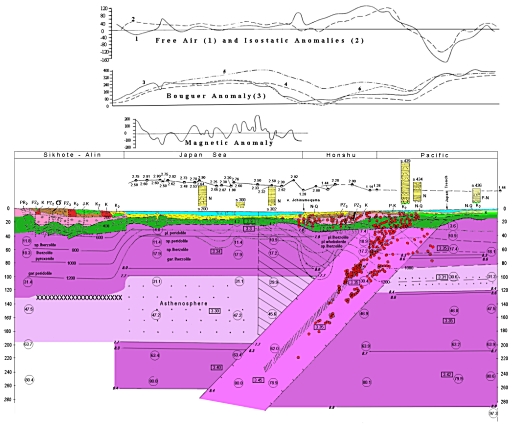
Earth's Crust
The large-scale geostructures crossed by the geotraverse, the
Sikhote-Alin, the deep basin of the Sea of Japan, the structures of
the Honshu I. and of the Pacific differ in both the crust and upper
mantle. The thickness of the crust within Primorje is 35-40 km, in
the Sea of Japan it is 12-15 km, on the Honshu I. about 30 km and in
the Pacific approximately 6-8 km. The Japanese deep basin is bounded
by two continental blocks composed of rocks of the Precambrian age.
The most ancient formations in Primorje are the early Proterozoic
metamorphic rocks uncovered in the Khanka massif (biotite and
amphibolite gneisses, amphibolite rocks, biotite and diopside
crystalline schists). The upper Proterozoic-early Cambrian
formations metamorphosed in the green-schist facies from a
terrigenous-carbonate-siliceous complex. These rocks seem to from
the basement of the Primorje structures which can be divided into 4
or 5 layers according to the deep-seismic sounding data.
The presence of the Precambrian rocks on the Honshu Island is estimated
to be quite probable. If this is so, the highly metamorphosed
gneisses and straurolite kyanite schists developer in Abakuma, and
the sillimanite gneisses, amphibolites and crystalline schists in
the from of xenolith observed in the Mesozoic serpentinite of the
Kitakami massif, are of the Precambrian age. It is probable that
Silurian limestone composing corals were formed under shallow-water
conditions thus transgressively overlapping the Precambrian rocks.
Paleozoic volcanogenic-sedimentary rocks are metamorphosed into
various crystalline schists of the green-schist facies. These rocks
from the "granite" layer of the island. The "basaltic" layer seems
to be composed of Precambrian metamorphic complexes including
granulite, hornblendite gabbro and amphibolites.
Within the region
of the geotraverse and magmatism shows the following features:
(i) In Primorje, the Sea of Japan and on Honshu Island, granitoids
prevail among the intrusive rocks.
(ii) In Primorje, granitoids have high K 2O content while within Japan with the exception of the
ancient Paleozoic carboniferous granites of Higami, the rocks have
natrium predominance.
The seismic cross-section of the Earth's crust
in the region of "green tuffs" is characterized by low velocity of
seismic waves is 7.6 km sec-1. By contrast, under the Kitakami
massif, velocities are more normal, i.e. 8.0-8.1 km sec-1. This
phenomenon seems to be related to active magmatic processes which
occurred during the Cenozoic period within the region of "green
tuffs" and to partial melting of the mantle.
Upper Mantle. Asthenosphere
Numerous research projects carried out by the Japanese scientists
were based on the interpretation of the surface and body waves of
the earthquakes and large events. These permitted the determination
within the upper mantle under the Sea of Japan of a thick layer
(over 100 km) with low velocities of P and S waves
( Kanamori, 1970 ;
The crust ..., 1972 ).
It was concluded that the upper mantle
between the continent and the island arc has lower velocities of
seismic waves (by about 0.3-0.4 km sec-1) as compared to the oceanic
region. It also has a greater degree of energy absorption. In the
upper mantle, within the transition zone from the Sea of Japan to
the Pacific basin, the change in velocity is rapid, not gradual.
The Benioff zone (100-150 km wide) is accepted as the boundary between
these structures. The great majority of earthquake foci are related
to this zone.
The upper mantle structure in the north-western
Pacific basin was studied by explosion seismology using the body
waves registered by ocean bottom seismographs. The velocity of
seismic waves is unusually high
( Asada and Shimamura, 1976 ).
The low velocity layer (wave-guide) at the depth of 100 km has a thickness
of 30-40 km and a velocity of 8.4-8.6 km sec-1 while under the Sea
of Japan at the same level, wave velocity is only 7.7 km sec-1. Such
a high velocity in the thin wave-guide of the upper mantle in the
north-western Pacific basin is an important contrast in the physical
properties of the mantle. It seems probable that "plastic"
asthenosphere observed under the Sea of Japan is completely absent.
The extent of the tack asthenosphere under the Sea of Japan is
supported by both geothermic and gravimetric observations. The
computation was made for the 1200 o temperature layer because at
greater temperatures the mechanism of heat transmission could be
sharply changed as the result of fractional melting.
The 2000 o
isotherm has a depth of about 100 km under the Sikhote-Alin where
the pressure exceeds 30 kbar. Under the Sea of Japan and the western
Honshu I. (region of "green tuffs") this isotherm ascends steeply to
40 km where the pressure is 11-17 kbar, within the Pacific the
isotherm descends again to the depth of 100-120 km where the
pressure increases accordingly to 30 kbar. The zone of partial
melting is probably more distinct under the Sea of Japan where high
temperature corresponds to low pressure. The zone of partial melting
is confirmed by magnetotelluric research to be the zone of higher
conductivity
( Vanyan et al., 1978 ).
This distribution correlates
well with magmatism. In the last 20 m.y. magmatic processes have
been active only within the region of the greatest uplift of the
1200 o isotherm, i.e. in the Sea of Japan and on the western Honshu I. In the Pacific (the north-werstern basin) magmatic activity
(tholeiite basalts outflow) seemed to occur about 100 m.y. ago, that
is during the Jurassic-Cretaceous period. In Primorje, at
approximately the same period, there was a widespread phase of
magmatism, predominantly of the acid type. In the Paleogene
intrusion occurred in the from of various dyke complexes and
subvolcanic bodies ranging from acid and alkaline to basic.
To construct the density section along the geotraverse, the gravity
effect of the crustal layers was computed. By subtracting this
gravity effect it was possible to model the anomalies relates to
density variations in the upper mantle. A good correlation of the
observed with the computed gravity anomaly was then obtained which
supported the reduced thickness and density of the lithosphere and
greater thickness of the asthenosphere under the Sea of Japan. This
gravity interpretation agress well with the seismological data.
The upper mantle composition and distribution of mantle rocks along the
geotraverse is shown in
Fig. 1
on the basis of a synopsis of the
petrographic analyses of xenoliths. Thus, it is inferred that within
Primorje, the upper levels of the mantle are composed of lerzolites,
spine lerzolites and pyroxenites with underlying garnet peridotites.
The uppermost mantle of the Sea of Japan also contains spinel
peridoties, spinel lerzolites and plagioclase peridotites, whereas
the uppermost mantle of Honshu Island is composed of spinel
lerzolites with a lesser amount of plagioclase lerzolites and
olivine websterites.
The crust and upper mantle on Honshu I. under
the Ichinomegata volcano is characterized by high water content and
comparatively low temperature, in contrast to the region under the
Sea of Japan, where the upper mantle and lower crust show a lack of
water
( Takahashi, 1978 ).
Focal Zone
The cross-section of the focal zone constructed by
Yoshii ( 1979 ) ,
Hasegawa et al. ( 1979 ) .
shows the hypocenters of the earthquakes
recorded from 1964 to 1973. It shows a seismically active layer with
a 50 o dip and 400 km depth.
The seismicity has the following features:
(i) the majority of the foci and of the energy release
falls within the first few tens of kilometers depth (to 50-70 km)
(ii) there is a distinct aseismic front in the upper mantle block
northwest of the axial part of the focal zone which is probably a
consequence of the difference in the physical-mechanical properties
of the blocks over the focal zone
(iii) there are clear differences
of focal mechanisms and stress-field between the upper region of
crustal earthquakes (predomimamtly compressive) and the base of the
focal zone
(iv) there is a double focal zone with compression and
extension oriented along it.
Conclusion
Interpretation of geological, seismological, gravimetric
magnetotelluric, petrographic, and geothermal data shows the
presence of a thick asthenospheric layer in the upper mantle of the
transition zone. In the adjacent Primorje and Pacific regions, low
velocity layers are not distinct. In the northwestern Pacific basin
the lithospheric thickness is 100 km, the mantle has higher density
and there is on clear asthenosphere layer. There is a layer with
somewhat lower seismic velocity ( 8.4 km sec-1 ), however, this
velocity is still considerably higher than that within the
transition zone at the same level. The Pacific basin has low heat
flow, and the majority of the magmatic activity can be dated as
Mesozoic. The transition zone has relatively high heat flow which
correlates well with the magmatism which occurred during the
Cenozoic period.
Several epochs are distinguished by the
predominance of compression and extension. The Late Paleozoic-Early
Mesozoic is mostly characterised by faults and faults-fractures
formed generally under extension conditions. Shifts, upthrusts,
strike-slip faults are typical of the end of the Mesozoic and
Paleogene. These structures combined with folded elements, which
appeared in the end of the Mesozoic, confirm the leading role of
compression stress. Compression stress changes to extension stress
in the end of Genozoic when thrust faults again become the dominant
type of faults.
This general pattern of deep structure within the
geotraverse must be considered when analysing the evolution of the
Earth's crust in this region. The upper mantle processes connected
with the formation of the asthenospheric layer appear to have a
close connection with the formation of the structures in the
transition zone.
Acknowledgements
The authors are expressing their deep gratitude to Drs. S. Asano, T. Yoshii, and E. Takahashi from Earthquake Research Institute and
Geological Institute of the Tokyo University for the scientific
materials and participation in discussion.
URL:
http://www.wdcb.ru/sep/traverses/Japan_Geotraverse/paper1.html
2001-2016 © WDC for SEP,
GC RAS
webmaster
|