Explanatory Note
Abstract |
Introduction |
Bathymetry |
Gravity Anomalies |
Seismicity
Magnetic and Electromagnetic Anomalies |
Geothermal Observations
Geology |
Crust |
Upper Mantle |
Concluding remarks |
Bibliography
Abstract
Within the framework of the joint Russia - Japan Geotraverse
Project, a geological-geophysical section of the crust and upper
mantle beneath Magellan Seamounts on the northwest Pacific Ocean
floor, Mariana Trench and Island Arc, Mariana Trough, Parece Vela
Basin, and the West Philippine Basin along the 18 o N
latitude has been constructed. The length of the Geotraverse is about
2500 km and the depth of the section is about 100 km. A set of
bathymetric, magnetic, gravity and geological maps along the
Geotraverse has also been constructed.
A combined interpretation of these geological-geophysical data is
presented. It is inferred that the isotherm of about
1000 o C, that may be interpreted to correspond to the
top of the asthenosphere, lies at about 50 km depth under the Eocene
West Philippine Basin, and at about 30 km depth under the Oligocene -
Miocene Parece Vela Basin. It approaches the crust under the Mariana
Trough, where backarc spreading and associated hydrothermal activity
is now active.
Introduction
Long before the initiation of the Global Geoscience Transect
Project of the International Lithosphere Program in the mid-1980's
(see for example,
Monger, 1986;
Gotze and Williams, 1991 ).
Russian and Japanese scientists were engaged with a joint Geotraverse
Projects. In 1976, they started the first Geotraverse Project across
the Sikhote Alin - Japan Sea - Honshu Island - Pacific Ocean region (
Rodnikov et al., 1982, 1985 ).
In 1985, the second Geotraverse Project was initiated on the
Philippine Sea Transect along the 18 o N
latitude . Later the Geotraverse was extended northwestward across the
Ryukyu arc-East China Sea to the North China Basin (
Rodnikov et al., 1991 ).
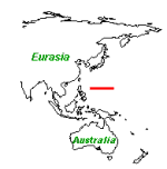
Location of the Philippine Sea Geotraverse
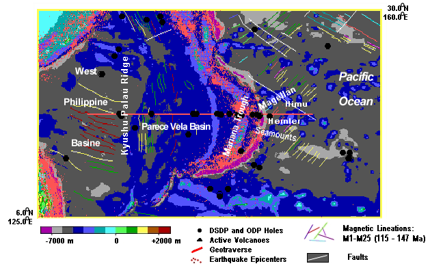 The Philippine Sea is the greatest marginal sea of the world. It
consists of the Mariana Trough, a present day active back-arc basin,
Oligocene-Miocene Parece Vela and Shikoku Basins and the Eocene West
Philippine Basin, separated by the undersea West Mariana Ridge and
Kyushu-Palau Ridge.
Karig (1971)
put forward a possible mechanism of genesis of the Philippine Sea,
attributing to episodic back-arc spreading of all these three basins.
Uyeda and Ben-Avraham (1972) ,
on the other hand, suggested that the West Philippine Basin was an
entrapment origin, followed by back-arc spreading of the Parece-Vela
Basin and the Mariana Trough largely caused by westward retreat of the
West Philippine Basin.
Later,
Seno and Maruyama (1984)
postulated that the back-arc spreading was caused by the seaward
retreat of the trench. In order to attain reliable evolutionary models
of the Philippine Sea, paleomagnetic data would play an important
role. In fact, numerous paleomagnetic studies have been conducted in
the region through analyses of rocks on the islands, DSDP core
samples, and magnetic anomalies (e.g.
Haston and Fuller, 1991 ;
Kinoshita, 1980 ;
Vacquier and Uyeda, 1967 ;
Louden, 1977 ) .
In the Geotraverse Project, however, main objective was focused on the
analysis of the present state, rather than paleo-reconstruction, so
that these paleomagnetic data are not treated in the present paper.
The Research Group has incorporated the results of investigations
conducted in the region, for instance those associated with deep sea
drilling programs (DSDP and IPOD) of the Glomar Challenger (
Fischer et al., 1971 ;
Karig et al., 1975 ;
Kroenke et al., 1980 ;
Hussong et al., 1981 ;
Taylor and Natland, 1995 ),
various Soviet and Japanese research cruises (
Geology of the Philippine Sea Floor,
1980 ;
Geology of the Northern Philippine Sea,
1985 ;
Vasiliev et al., 1985 ;
Shcheka et al., 1986 )
as well as the materials reported in the form of maps (
Geophysical Atlas of the East and Southeast Asian
Seas, 1978 ;
Plate Tectonic Map of the Circum-Pacific Region,
1981 ).
They also carried out original investigations. R/V "Vulcanolog"
was used to survey the Magellan Seamounts, the Parece Vela Basin and
the West Philippine Basin (
Muraviev et al., 1988 ),
while Japanese scientists participated in submarine studies by the
deep submersible "Alvin" under a US-Japan Cooperative Program in the
Mariana Trough and forearc that led to the discovery of hydrothermal
activity and associated sulfide mineralization (e.g.
Craig et al., 1987 :
Moore and Stakes, 1990 ).
The result of works consists of a set of maps:
bathymetric, magnetic, gravity and geological,
and geological-geophysical section of the tectonosphere to a depth
of 100 km.
The term tectonosphere corresponds here to the outer layer of the
earth, including the lithosphere and asthenosphere, where most of the
earth's tectonic and magmatic processes occur. Some of the results of
the Geotraverse Project and appropriate references are given in
Rodnikov et al., 1991 ;
Rodnikov et al., 1996) .
The Philippine Sea is the greatest marginal sea of the world. It
consists of the Mariana Trough, a present day active back-arc basin,
Oligocene-Miocene Parece Vela and Shikoku Basins and the Eocene West
Philippine Basin, separated by the undersea West Mariana Ridge and
Kyushu-Palau Ridge.
Karig (1971)
put forward a possible mechanism of genesis of the Philippine Sea,
attributing to episodic back-arc spreading of all these three basins.
Uyeda and Ben-Avraham (1972) ,
on the other hand, suggested that the West Philippine Basin was an
entrapment origin, followed by back-arc spreading of the Parece-Vela
Basin and the Mariana Trough largely caused by westward retreat of the
West Philippine Basin.
Later,
Seno and Maruyama (1984)
postulated that the back-arc spreading was caused by the seaward
retreat of the trench. In order to attain reliable evolutionary models
of the Philippine Sea, paleomagnetic data would play an important
role. In fact, numerous paleomagnetic studies have been conducted in
the region through analyses of rocks on the islands, DSDP core
samples, and magnetic anomalies (e.g.
Haston and Fuller, 1991 ;
Kinoshita, 1980 ;
Vacquier and Uyeda, 1967 ;
Louden, 1977 ) .
In the Geotraverse Project, however, main objective was focused on the
analysis of the present state, rather than paleo-reconstruction, so
that these paleomagnetic data are not treated in the present paper.
The Research Group has incorporated the results of investigations
conducted in the region, for instance those associated with deep sea
drilling programs (DSDP and IPOD) of the Glomar Challenger (
Fischer et al., 1971 ;
Karig et al., 1975 ;
Kroenke et al., 1980 ;
Hussong et al., 1981 ;
Taylor and Natland, 1995 ),
various Soviet and Japanese research cruises (
Geology of the Philippine Sea Floor,
1980 ;
Geology of the Northern Philippine Sea,
1985 ;
Vasiliev et al., 1985 ;
Shcheka et al., 1986 )
as well as the materials reported in the form of maps (
Geophysical Atlas of the East and Southeast Asian
Seas, 1978 ;
Plate Tectonic Map of the Circum-Pacific Region,
1981 ).
They also carried out original investigations. R/V "Vulcanolog"
was used to survey the Magellan Seamounts, the Parece Vela Basin and
the West Philippine Basin (
Muraviev et al., 1988 ),
while Japanese scientists participated in submarine studies by the
deep submersible "Alvin" under a US-Japan Cooperative Program in the
Mariana Trough and forearc that led to the discovery of hydrothermal
activity and associated sulfide mineralization (e.g.
Craig et al., 1987 :
Moore and Stakes, 1990 ).
The result of works consists of a set of maps:
bathymetric, magnetic, gravity and geological,
and geological-geophysical section of the tectonosphere to a depth
of 100 km.
The term tectonosphere corresponds here to the outer layer of the
earth, including the lithosphere and asthenosphere, where most of the
earth's tectonic and magmatic processes occur. Some of the results of
the Geotraverse Project and appropriate references are given in
Rodnikov et al., 1991 ;
Rodnikov et al., 1996) .
Bathymetry
The Geotraverse crosses the northwest Pacific Basin in the
region of Magellan Seamounts, Mariana Trench, Mariana Ridge
(island arc), Mariana Trough, West Mariana Ridge, Parece Vela
Basin, Kyushu - Palau Ridge and the West Philippine Basin. There are
the bathymetric map (
General Bathymetric Chart of the Oceans,
1984 )
and the depth profile of the Geotraverse.
Bathymetric Map
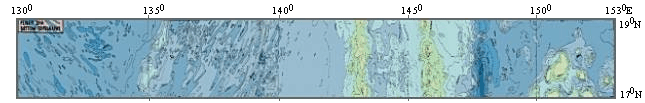
 More detailed view of the Bathymetric Map
Depth Profile
 Peaks of the flat-topped Magellan Seamounts rise some 1500 - 1600
m above the Pacific seafloor. Their volcanic basements are crowned
with carbonate "hats" that have been abraded in a subaqueous
environment. The seaward wall of the Mariana Trench, where the
Geotraverse crosses has a rather gentle slope of about 5 o
and shows a series of faulted blocks, revealing welldeveloped
horst-graben structures (
Hilde, 1983 )
as a result of downward bending of the subducting Pacific plate (e.g.
p. 130, Turcotte and Schubert,
1982 ).
The landward wall of the Mariana Trench has steeper slope and normal
faults indicating that tensional tectonic stresses are prevailing
there (e. g.
Hussong et al., 1981 ).
The Mariana Ridge is an island arc, which used to be classified as
Cordilleran type orogenic zone in contrast to the Alpine type orogenic
zone. In the plate tectonic framework, the Cordilleran type orogenic
zones are believed to be related to subduction of oceanic plate and
the Alpine type to continental collision. The subduction related
(Cordilleran) orogenic zones are now subdivided into the Chilean type
subduction zone and the Mariana type subduction zone, based on their
contrasting features and the Mariana Ridge is considered to be the end
member of the Mariana type (e. g.
Uyeda and Kanamori, 1979 ;
Uyeda, 1982; 1987 ).
The Mariana Ridge consists of a series of volcanic islands, most of
which are active, while the submarine West Mariana Ridge consists of
extinct volcanoes. The West Mariana Ridge is considered to be a
remnant arc that was split away from the Mariana Ridge by the back-arc
spreading of the Mariana Trough (
Karig, 1971 ).
The two ridges are separated by the 4 km deep Mariana Trough of which
bottom topography indicates that the back-arc spreading was symmetric
and centered at an axial graben trending about 330 o
at 18 o N. On both sides of this graben the trough crust
is broken by normal faults into approximately north-south trending
ridges that are rotated with their steep sides facing the apparent
spreading center (
Hussong et al., 1981 ).
The eastern portion is covered by a westward thinning apron of
volcanic materials supplied from the volcanoes of the Mariana arc.
Central and western portion has no or very thin sedimentary cover
showing a rough surface topography.
The Parece Vela Basin is located between the submarine West
Mariana and Kyushu - Palau Ridges. Where crossed by the Geotraverse,
it is about 850 km wide and the depth exceeds 4 km. The bottom is
relatively smooth with sedimentary cover. A roughly N-S elongated
Central High divides the Basin into two halves, with different
morphologies and other geological-geophysical features. The Central
High rises about 1 km above the sea-bottom level; its surface has
almost no sedimentary cover and is dissected by a system of grabens
(6-7.5 km deep) and horsts. This block system forms Parece Vela Rift.
The eastern part of the basin is a flat plain with thin sedimentary
cover. The western part of the Parece Vela Basin has block structure
with troughs and submarine ridges of north-eastern strike covered by
thin-layered sediments. The central uplift is considered as an extinct
back-arc spreading center that formed the Parece Vela Basin in the
late Eocene and Oliogocene time (
Karig et al., 1975 ;
Mrozowski and Hayes, 1979 ;
Kroenke et al., 1980 ).
The Kyushu - Palau Ridge, which is believed to be the remnant arc
associated with the back-arc spreading of the Parece Vela Basin, is a
chain of extinct volcanoes which rises about 3 km above the adjacent
basin floor. The Geotraverse profile terminates in the West Philippine
Basin which is characterized by numerous NW - SE trending depressions
and uplifts, that are believed to be the spreading fabric of the basin
(e.g.
Uyeda and Ben-Avraham, 1972 ).
One of the characteristic features of the bathymetry of the
Philippine Sea is that its depth does not follow the same age-depth
relation for the normal ocean (
Sclater et al., 1976 ;
Kobayashi, 1984 ;
Park et al., 1990 ).
According to Park et al. (1990),the basement depth of the Philippine
Sea is about 800 m deeper than normal ocean of the same age. This
seems to constitute a yet unclarified important constraint on the deep
structure and formation process of the Philippine Sea. As will be
mentioned later, heat flow-age relation of the Philippine Sea is
indistinguishable from that of the normal oceans (
Anderson, 1980 ;
Yamano and Uyeda, 1988 ).
Peaks of the flat-topped Magellan Seamounts rise some 1500 - 1600
m above the Pacific seafloor. Their volcanic basements are crowned
with carbonate "hats" that have been abraded in a subaqueous
environment. The seaward wall of the Mariana Trench, where the
Geotraverse crosses has a rather gentle slope of about 5 o
and shows a series of faulted blocks, revealing welldeveloped
horst-graben structures (
Hilde, 1983 )
as a result of downward bending of the subducting Pacific plate (e.g.
p. 130, Turcotte and Schubert,
1982 ).
The landward wall of the Mariana Trench has steeper slope and normal
faults indicating that tensional tectonic stresses are prevailing
there (e. g.
Hussong et al., 1981 ).
The Mariana Ridge is an island arc, which used to be classified as
Cordilleran type orogenic zone in contrast to the Alpine type orogenic
zone. In the plate tectonic framework, the Cordilleran type orogenic
zones are believed to be related to subduction of oceanic plate and
the Alpine type to continental collision. The subduction related
(Cordilleran) orogenic zones are now subdivided into the Chilean type
subduction zone and the Mariana type subduction zone, based on their
contrasting features and the Mariana Ridge is considered to be the end
member of the Mariana type (e. g.
Uyeda and Kanamori, 1979 ;
Uyeda, 1982; 1987 ).
The Mariana Ridge consists of a series of volcanic islands, most of
which are active, while the submarine West Mariana Ridge consists of
extinct volcanoes. The West Mariana Ridge is considered to be a
remnant arc that was split away from the Mariana Ridge by the back-arc
spreading of the Mariana Trough (
Karig, 1971 ).
The two ridges are separated by the 4 km deep Mariana Trough of which
bottom topography indicates that the back-arc spreading was symmetric
and centered at an axial graben trending about 330 o
at 18 o N. On both sides of this graben the trough crust
is broken by normal faults into approximately north-south trending
ridges that are rotated with their steep sides facing the apparent
spreading center (
Hussong et al., 1981 ).
The eastern portion is covered by a westward thinning apron of
volcanic materials supplied from the volcanoes of the Mariana arc.
Central and western portion has no or very thin sedimentary cover
showing a rough surface topography.
The Parece Vela Basin is located between the submarine West
Mariana and Kyushu - Palau Ridges. Where crossed by the Geotraverse,
it is about 850 km wide and the depth exceeds 4 km. The bottom is
relatively smooth with sedimentary cover. A roughly N-S elongated
Central High divides the Basin into two halves, with different
morphologies and other geological-geophysical features. The Central
High rises about 1 km above the sea-bottom level; its surface has
almost no sedimentary cover and is dissected by a system of grabens
(6-7.5 km deep) and horsts. This block system forms Parece Vela Rift.
The eastern part of the basin is a flat plain with thin sedimentary
cover. The western part of the Parece Vela Basin has block structure
with troughs and submarine ridges of north-eastern strike covered by
thin-layered sediments. The central uplift is considered as an extinct
back-arc spreading center that formed the Parece Vela Basin in the
late Eocene and Oliogocene time (
Karig et al., 1975 ;
Mrozowski and Hayes, 1979 ;
Kroenke et al., 1980 ).
The Kyushu - Palau Ridge, which is believed to be the remnant arc
associated with the back-arc spreading of the Parece Vela Basin, is a
chain of extinct volcanoes which rises about 3 km above the adjacent
basin floor. The Geotraverse profile terminates in the West Philippine
Basin which is characterized by numerous NW - SE trending depressions
and uplifts, that are believed to be the spreading fabric of the basin
(e.g.
Uyeda and Ben-Avraham, 1972 ).
One of the characteristic features of the bathymetry of the
Philippine Sea is that its depth does not follow the same age-depth
relation for the normal ocean (
Sclater et al., 1976 ;
Kobayashi, 1984 ;
Park et al., 1990 ).
According to Park et al. (1990),the basement depth of the Philippine
Sea is about 800 m deeper than normal ocean of the same age. This
seems to constitute a yet unclarified important constraint on the deep
structure and formation process of the Philippine Sea. As will be
mentioned later, heat flow-age relation of the Philippine Sea is
indistinguishable from that of the normal oceans (
Anderson, 1980 ;
Yamano and Uyeda, 1988 ).
Gravity Anomalies
The gravity field along the Geotraverse is rather
complicated reflecting structural and density heterogeneities of the
tectonosphere (
Tomoda and Fujimoto, 1982 ;
Gainanov and Stroev, 1988 ;
Stroev et al., 1989 ).
Free-Air Gravity Anomaly Map
 More detailed view of
the Gravity Map
The North-West Pacific has a quiet free air anomaly field having
small values ( +10 - +13 mgal). The Mariana Trench free air anomalies
are strongly negative, up to -160 - -200 mgal. The Mariana Ridge has
intensive positive free air anomalies of +50 - +80 mgal. The Mariana
Trough has a positive free air anomaly field with values of +20 - +30
mgal. The West Mariana Ridge has higher free air anomalies of about
+60 - +70 mgal, similar to but more smooth than that of the Mariana
Ridge. The Parece Vela Basin has a positive free air anomaly field of
about +20 - +30 mgal. The Kyusyu-Palau Ridge has slightly negative or
zero free air anomalies. The West Philippine Basin gravity field is
also quiet, the free air anomalies are slightly positive and negative.
Recently, gravity data from satellite observations had became
available. The global satellite gravity map (
Sandwell and Smith, 1992 )
shows generally the same features as above.
On the basis of a joint interpretation of the results of deep
seismic sounding (DSS) and gravity data, density models of the
tectonosphere along the Geotraverse were constructed (
Stroev et al., 1989 ).
In developing the density model of the mantle, the gravity effect of
the crust was calculated first using the seismic data and the
empirical relationship between rock density and P-wave velocity. By
subtracting this gravity effect of the crust from the observed gravity
anomalies, the "residual " or the mantle gravity anomalies " (RMA)
were obtained.
More detailed view of
the Gravity Map
The North-West Pacific has a quiet free air anomaly field having
small values ( +10 - +13 mgal). The Mariana Trench free air anomalies
are strongly negative, up to -160 - -200 mgal. The Mariana Ridge has
intensive positive free air anomalies of +50 - +80 mgal. The Mariana
Trough has a positive free air anomaly field with values of +20 - +30
mgal. The West Mariana Ridge has higher free air anomalies of about
+60 - +70 mgal, similar to but more smooth than that of the Mariana
Ridge. The Parece Vela Basin has a positive free air anomaly field of
about +20 - +30 mgal. The Kyusyu-Palau Ridge has slightly negative or
zero free air anomalies. The West Philippine Basin gravity field is
also quiet, the free air anomalies are slightly positive and negative.
Recently, gravity data from satellite observations had became
available. The global satellite gravity map (
Sandwell and Smith, 1992 )
shows generally the same features as above.
On the basis of a joint interpretation of the results of deep
seismic sounding (DSS) and gravity data, density models of the
tectonosphere along the Geotraverse were constructed (
Stroev et al., 1989 ).
In developing the density model of the mantle, the gravity effect of
the crust was calculated first using the seismic data and the
empirical relationship between rock density and P-wave velocity. By
subtracting this gravity effect of the crust from the observed gravity
anomalies, the "residual " or the mantle gravity anomalies " (RMA)
were obtained.
Mantle Gravity Anomalies along the Geotraverse
 Features to be noted on the RMA profile are: minima over the
Mariana Ridge (- 300 mgal), the West Mariana Ridge (-220 mgal) and the
Kyusyu-Palau Ridge (-150 mgal), moderately negative values over the
Mariana Trough and the Parece Vela Basin, and maximum over the section
between the axis of the Mariana Trench and the outer rise (+40 mgal).
RMA is potentially a useful quantity to estimate the structure and
dynamic state of the tectonosphere but suffers from various possible
errors such as uncertainties in the empirical relationship between rock
density and P-wave velocity, non-uniqueness in the inversion of the DSS
time-distance curves and errors in computing the gravity anomalies due
to three-dimensional effects.
With the uncertainties in mind, however, the negative anomalies
over the Mariana Trough and Parece Vela Basin may be interpreted as
caused by thinning of the lithosphere and corresponding thickening of
the asthenosphere and the positive anomalies outward the Mariana
Trench by the existence of subducting lithospheric slab.
Features to be noted on the RMA profile are: minima over the
Mariana Ridge (- 300 mgal), the West Mariana Ridge (-220 mgal) and the
Kyusyu-Palau Ridge (-150 mgal), moderately negative values over the
Mariana Trough and the Parece Vela Basin, and maximum over the section
between the axis of the Mariana Trench and the outer rise (+40 mgal).
RMA is potentially a useful quantity to estimate the structure and
dynamic state of the tectonosphere but suffers from various possible
errors such as uncertainties in the empirical relationship between rock
density and P-wave velocity, non-uniqueness in the inversion of the DSS
time-distance curves and errors in computing the gravity anomalies due
to three-dimensional effects.
With the uncertainties in mind, however, the negative anomalies
over the Mariana Trough and Parece Vela Basin may be interpreted as
caused by thinning of the lithosphere and corresponding thickening of
the asthenosphere and the positive anomalies outward the Mariana
Trench by the existence of subducting lithospheric slab.
Seismicity
Seismicity of the Mariana arc has only been studied using
teleseismic data (e. g.
Katsumata and Sykes, 1969 ;
Isacks and Barazangi, 1977 ;
Eguchi, 1984 ),
except for one OBS study (
Hussong and Sinton, 1983 ).
Seismic foci shown in the bottom cross-section are based on these and
Preliminary Determination of Epicenters
(PDE)
data.
Earthquake Spatial Distribution in the Region of the Geotraverse

The Depth Distribution of 388 Earthquake
Hypocenters in 1 o Zone along the Philippine Sea Geotraverse
according to the World Earthquake Catalog PDE
for the period 1904 - 1999
Shallow interplate seismicity occurs along the arc. It lacks,
however, truly great thrust earthquakes. This lack of great thrust
earthquakes is, together with the tensional source mechanism of many
shallow earthquakes under the trench, interpreted as indicating a
weaker mechanical coupling between the landward plate and subducting
oceanic plate as compared to, for instance, that at the Chilean arc.
This constituted one of the main bases for classifying subduction
zones into the Mariana and Chilean types (
Uyeda and Kanamori, 1979 ;
Uyeda, 1982; 1987 ).
Shimamoto et al., (1993)
recently put forward a rheological model to explain this difference in
terms of the degree of mechanical coupling between the slab and the
overlying mantle wedge under various arcs. They attributed the
difference in the mechanical coupling to that of the subterranean
thermal states.
The character of the Mariana Trough seismicity is not clear yet.
Many low-magnitude shallow earthquakes accompanying the active
spreading were detected here by
Hussong and Sinton (1983) .
The most deep earthquakes were detected in these studies at depth
about 12 - 15 km, with maximum seismic activity in the uppermost part
of the crust. But PDE data are rather different. According to these
data, the seismic activity of the upper 20 km of the crust is
moderate. Most earthquakes occur in the Trough area in the depth
interval 30 - 40 km. Three events were detected (before 1989) at the
depth 40 - 50 km. One can propose that above mentioned discrepancy is
connected with the poor resolution of depth of foci in this area by
the wourld-wide set of seismic stations, but this suggestion needs
further support. Shallow earthquakes in the Mariana Trough region were
shown to have strike slip source mechanisms as expected for those
associated with the spreading center-transform fault activity of the
Trough (
Eguchi, 1984 ).
The Wadati-Benioff zone of deep earthquakes with a steep dip
angle, almost vertical at the Geotraverse latitude, extends to a depth
of about 600 km (
Katsumata and Sykes, 1969 ).
Creager and Jordan (1986) ,
through travel time residual sphere analysis, indicated that the high
velocity zone of the subducting slab extends beyond the limit of
deepest earthquakes and reaches a depth of at least 1000 km. On the
basis of this observation, these authors proposed that the subducting
slab penetrates the 670 km discontinuity.
Spakman et al. (1989)
and
Van der Hirst et al. (1991)
also have imaged a high velocity slab penetrating the 670 km
discontinuity into the lower mantle under the Mariana arc, in contrast
to the slab deflected at the 670 km discontinuity in the Izu-Bonin
arc. A similar image has been obtained by
Fukao et al. (1992)
employing a different seismic tomography scheme. They have also
demonstrated that descending slabs in the western Pacific subduction
zones tend to bend subhorizontally at the 670 km discontinuity. They
interpreted that the slabs tend to stay stagnant there before finally
sink deeper. Unfortunately, the reliability of the tomographic images,
constrained by the present distribution of seismic stations and
hypocenters, is lower in the Geotraverse region than in the souther
Kurile-Japan-Izu-Bonin region (
Fukao et al., 1992 ).
Magnetic and Electromagnetic Anomalies
Along the Geotraverse, magnetic anomalies of low amplitudes (less
than 200 nT ) are typical in the Philippine Sea.
Magnetic Total Intensity Anomaly Map
 More detailed view of the Magnetic Map
In the Pacific Ocean east of the Mariana arc, the more intense
linear magnetic anomalies indicate a Mesozoic age of the crust (e.g.
Handschumacher et al., 1988 ).
In the Parece Vela Basin, the age of magnetic anomalies ranges from 30
Ma ( Chron 10 ) to 17 Ma ( Chron 5D ) (
Mrozowski and Hayes, 1979 ).
The West Philippine Basin is characterized by 60-46 Ma NW-SE trending
linear magnetic anomalies ( Chron 26-20 ) and 44-35 Ma E-W trending
ones ( Chron 19-13 ) (
Hilde and Lee, 1984 ).
In the northern West Philippine Basin, a layer of high electrical
conductivity of 0.5 S/m was detected at a depth of 80-100 km (
Honkura et al., 1981 ).
But in a more recent model derived from analysis of seafloor data, it
was found that the conducting layer exists at a depth of 60 km and the
conductivity is of the order of 0.01 S/m, much lower than the
previvous estimation (
Shimakawa and Honkura, 1991 ).
In contrast to expectation, within the area of the Mariana Trough in
which active spreading is occurring, upper mantle electric
conductivity to the depth of 40-60 km is reported to be as low as
0.002 S/m and, from that depth, it increases monotonously with depth
to 1 S/m at a depth of 700 km (
Filloux, 1983 ).
In the Mariana fore-arc area, the electrical conductivity to a
depth of 10 km is high, about 0.03 S/m. At 70 to 420 km depth, it is
low ( 0.002 S/m ) and at the 420 km depth it increases to 0.04 S/m. It
remains practically constant in the underlying 300 km thick layer. At
the depth of 720 km, the conductivity begins to increase and
eventually reaches 1 S/m at 800 km depth (
Filloux, 1983 ).
More detailed view of the Magnetic Map
In the Pacific Ocean east of the Mariana arc, the more intense
linear magnetic anomalies indicate a Mesozoic age of the crust (e.g.
Handschumacher et al., 1988 ).
In the Parece Vela Basin, the age of magnetic anomalies ranges from 30
Ma ( Chron 10 ) to 17 Ma ( Chron 5D ) (
Mrozowski and Hayes, 1979 ).
The West Philippine Basin is characterized by 60-46 Ma NW-SE trending
linear magnetic anomalies ( Chron 26-20 ) and 44-35 Ma E-W trending
ones ( Chron 19-13 ) (
Hilde and Lee, 1984 ).
In the northern West Philippine Basin, a layer of high electrical
conductivity of 0.5 S/m was detected at a depth of 80-100 km (
Honkura et al., 1981 ).
But in a more recent model derived from analysis of seafloor data, it
was found that the conducting layer exists at a depth of 60 km and the
conductivity is of the order of 0.01 S/m, much lower than the
previvous estimation (
Shimakawa and Honkura, 1991 ).
In contrast to expectation, within the area of the Mariana Trough in
which active spreading is occurring, upper mantle electric
conductivity to the depth of 40-60 km is reported to be as low as
0.002 S/m and, from that depth, it increases monotonously with depth
to 1 S/m at a depth of 700 km (
Filloux, 1983 ).
In the Mariana fore-arc area, the electrical conductivity to a
depth of 10 km is high, about 0.03 S/m. At 70 to 420 km depth, it is
low ( 0.002 S/m ) and at the 420 km depth it increases to 0.04 S/m. It
remains practically constant in the underlying 300 km thick layer. At
the depth of 720 km, the conductivity begins to increase and
eventually reaches 1 S/m at 800 km depth (
Filloux, 1983 ).
Geothermal Observations
Within the Pacific Ocean portion of the Geotraverse, four heat
flow measurements were conducted on the Magellan Seamounts, which are
formed of Late Cretaceous alkaline basalts (
Smith et al., 1989 ).
Two measurements gave heat flow values of 84 and 96 mW/m 2
that are higher than expected for the old oceanic basins, while the
other two gave more normal values of 47 and 48 mW/m 2 (
Muraviev et al., 1988 ).
Measurements were not made in the deep portion of the Mariana Trench
along the Geotraverse, but to the south of it one measurement was made
at a water depth in excess of 10000 m to give a value of 15
mW/m 2 .
Heat Flow along the Geotraverse
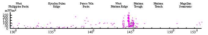 The highest heat flow values were obtained in the actively
spreading Mariana Trough. In an earlier study,
Anderson (1975)
found that heat flow is high in the axial zone of the central ridge,
highest value reaching 200 mW/m 2 , whereas it was low on
the flank. On DSDP Leg 60, downhole heat flow measurements were
conducted by a newly developed probe utilizing solidstate memory
device (
Uyeda and Horai, 1981 ),
again giving highly variable values. Finally, detailed heat flow
survey in 2-3 Ma old seafloor in the Mariana Trough along the
Geotraverse, by means of a multiple-penetration probe by
Hobart et al., (1983) ,
revealed extremely localized distribution of high (up to 2000 mW/m
2 ) and low heat flow. These results clearly indicated
that intense hydrothermal activity is taking place in the crust of the
Trough.
Direct observation of submarine hydrothermal activity in the
Mariana Trough was accomplished through a US-Japan Cooperative Project
by the use of the deep submersible "Alvin" in 1987. On the Trough
axis, chimneys and springs discharging high temperature ( up to
280 o C) fluid were found (
Craig et al., 1987 ;
Hessler et al., 1987 ).
In the off axis areas where high heat flow mounds had been discovered
earlier, hydrothermal springs with lower temperature fluids were
discovered (
Leinen et al., 1987 ).
These findings testify that the Mariana back-arc spreading center has
much in common with active spreading centers along typical midoceanic
ridges.
Average value of the measured heat flow in the western portion of
the Parece Vela Basin is 33121 mW/m 2 , whereas it is
76121 mW/m 2 in its eastern portion. Two highest values
of 146 and 180 mW/m 2 were obtained from the graben-like
structure of the Parece Vela paleo-rift zone during the "Vulcanolog"
cruise in 1986 (
Muraviev et al., 1988 ).
In the West Philippine Basin, which forms the oldest part of the
Philippine Sea, the average observed heat flow is 62138 mW/m 2
. Heat flow is highest in the Mariana Trough and decreases for
older basins in the same way as in normal oceans (
Anderson, 1980 ;
Yamano and Uyeda, 1988 ).
Using a model of a 2D non-steady thermal conduction scheme,
Smirnov et al. (1991)
calculated the temperature in the upper part of the Earth along
the Geotraverse from the heat flow data as shown in the cross-
section.
The highest heat flow values were obtained in the actively
spreading Mariana Trough. In an earlier study,
Anderson (1975)
found that heat flow is high in the axial zone of the central ridge,
highest value reaching 200 mW/m 2 , whereas it was low on
the flank. On DSDP Leg 60, downhole heat flow measurements were
conducted by a newly developed probe utilizing solidstate memory
device (
Uyeda and Horai, 1981 ),
again giving highly variable values. Finally, detailed heat flow
survey in 2-3 Ma old seafloor in the Mariana Trough along the
Geotraverse, by means of a multiple-penetration probe by
Hobart et al., (1983) ,
revealed extremely localized distribution of high (up to 2000 mW/m
2 ) and low heat flow. These results clearly indicated
that intense hydrothermal activity is taking place in the crust of the
Trough.
Direct observation of submarine hydrothermal activity in the
Mariana Trough was accomplished through a US-Japan Cooperative Project
by the use of the deep submersible "Alvin" in 1987. On the Trough
axis, chimneys and springs discharging high temperature ( up to
280 o C) fluid were found (
Craig et al., 1987 ;
Hessler et al., 1987 ).
In the off axis areas where high heat flow mounds had been discovered
earlier, hydrothermal springs with lower temperature fluids were
discovered (
Leinen et al., 1987 ).
These findings testify that the Mariana back-arc spreading center has
much in common with active spreading centers along typical midoceanic
ridges.
Average value of the measured heat flow in the western portion of
the Parece Vela Basin is 33121 mW/m 2 , whereas it is
76121 mW/m 2 in its eastern portion. Two highest values
of 146 and 180 mW/m 2 were obtained from the graben-like
structure of the Parece Vela paleo-rift zone during the "Vulcanolog"
cruise in 1986 (
Muraviev et al., 1988 ).
In the West Philippine Basin, which forms the oldest part of the
Philippine Sea, the average observed heat flow is 62138 mW/m 2
. Heat flow is highest in the Mariana Trough and decreases for
older basins in the same way as in normal oceans (
Anderson, 1980 ;
Yamano and Uyeda, 1988 ).
Using a model of a 2D non-steady thermal conduction scheme,
Smirnov et al. (1991)
calculated the temperature in the upper part of the Earth along
the Geotraverse from the heat flow data as shown in the cross-
section.
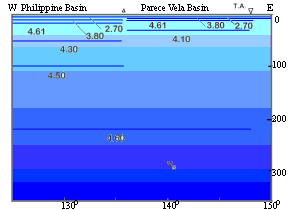
Deep Temperatures in the Upper Mantle along the Geotraverse
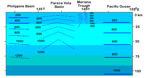 It can be observed that the older the oceanic lithosphere the
deeper the isotherms. Under the spreading center of the Mariana
Trough, observed heat flow values are so scattered, due to
hydrothermal circulation in the crust, that meaningful average heat
flow can not be assessed. From the fact that active sea floor
spreading is taking place there, however, the temperature of 1000-1200
o C, the approximate temperature of partial melting of
dry - wet ultrabasic rocks, is likely to be occurring at least locally
at a very shallow depth of say 5-10 km below sea bottom.
It can be observed that the older the oceanic lithosphere the
deeper the isotherms. Under the spreading center of the Mariana
Trough, observed heat flow values are so scattered, due to
hydrothermal circulation in the crust, that meaningful average heat
flow can not be assessed. From the fact that active sea floor
spreading is taking place there, however, the temperature of 1000-1200
o C, the approximate temperature of partial melting of
dry - wet ultrabasic rocks, is likely to be occurring at least locally
at a very shallow depth of say 5-10 km below sea bottom.
Geology
Considerable amount of information is now available on the geology
of the Geotraverse.
Geological Map
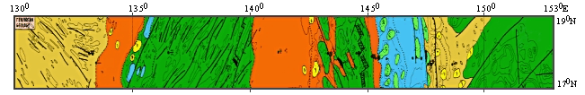
More detailed view
of the Geological Map
 The Magellan Seamounts were studied during cruises of the R/V
Akademik A. Nesmeyanov (
Vasiliev et al., 1985 )
and R/V Akademik M. Keldysh (
Kazmin et al., 1987 ).
Olivine-plagioclase and pyroxene-plagioclase basalts, agglomerate
lavas, breccias and tuffs of basic composition were dredged along the
Geotraverse on the southern and southwestern slopes of seamounts
between the 1400 m and 4800 m depths ( Table 1
). During the 1985 cruise of R/V
Conrad, some samples were collected from Himu Seamount and Hemler
Guyot of the Magellan Seamount Chain (
Smith et al., 1989 ).
Pillow basalts and flows were the dominant rock types recovered from
the Himu Seamount, whereas mostly submarine volcaniclastics and
carbonates were recovered from Hemler Guyot. The extrusives were
alkali basalts. Basalts of the Himu Seamount have an 40Ar / 39Ar age
of 120 Ma and basalts of the Hemler Guyot 100 Ma ( Table 2 ).
Twenty boreholes were drilled in the Philippine Sea region during
Legs 6, 34, 59 and 60 of the Glomar Challenger.
The Magellan Seamounts were studied during cruises of the R/V
Akademik A. Nesmeyanov (
Vasiliev et al., 1985 )
and R/V Akademik M. Keldysh (
Kazmin et al., 1987 ).
Olivine-plagioclase and pyroxene-plagioclase basalts, agglomerate
lavas, breccias and tuffs of basic composition were dredged along the
Geotraverse on the southern and southwestern slopes of seamounts
between the 1400 m and 4800 m depths ( Table 1
). During the 1985 cruise of R/V
Conrad, some samples were collected from Himu Seamount and Hemler
Guyot of the Magellan Seamount Chain (
Smith et al., 1989 ).
Pillow basalts and flows were the dominant rock types recovered from
the Himu Seamount, whereas mostly submarine volcaniclastics and
carbonates were recovered from Hemler Guyot. The extrusives were
alkali basalts. Basalts of the Himu Seamount have an 40Ar / 39Ar age
of 120 Ma and basalts of the Hemler Guyot 100 Ma ( Table 2 ).
Twenty boreholes were drilled in the Philippine Sea region during
Legs 6, 34, 59 and 60 of the Glomar Challenger.
Site Locations for Legs 59, and 60
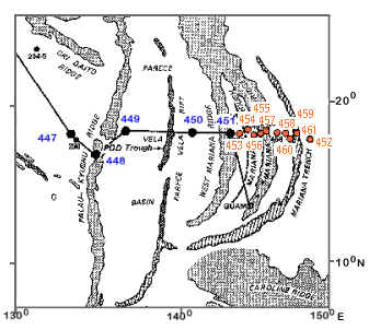 Additional information has been provided through dredge hauls by
Russian, Japanese, American and Chinese research vessels.
Additional information has been provided through dredge hauls by
Russian, Japanese, American and Chinese research vessels.
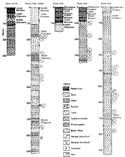
Stratigraphic Columns for Sites Drilled During Leg 59
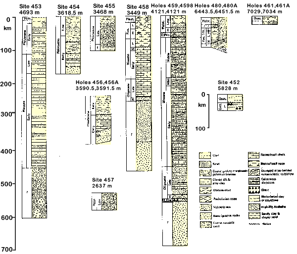
Lithologic Columns for Sites Drilled During Leg 60
 Subducting westernmost Pacific plate at the Geotraverse has a
chert layer of probable Campanian age on which some 50 meters of
Neogene sediments lie according to the Leg 60 drilling (
Hussong et al., 1981 ).
This agrees with the results of many other drillings in the western
Pacific showing a wide spread Cretaceous-Neogene hiatus.
The inner (island arc) wall of the Mariana Trench, from the trench
axis of about 8600 m depth to the trench slope break of about 4100 m
depth, is almost free of sediments, attesting to the almost complete
subduction of sedimentary cover on the subducting Pacific plate.
Dredge samples from this part of the trench wall collected by R/V
Mariana were also apparently island arc derived harzburgite,
serpentinite, lherzolite, massive and layered gabbro and basaltic to
dacitic volcanic rocks (
Bloomer and Hawkins, 1983 ).
The oldest formation found in the Mariana arc comprises pillow
lavas, tuffs and conglomerates of the Upper Eocene age, indicating the
initiation of subduction along the Mariana arc at that time. They are
overlain by Oligocene and Miocene volcanics. Carbonate and clayey
sediments have been recorded on the islands of the Mariana arc. The
Pliocene-Quaternary volcanoes form the present arc. The Mariana Trough
is about 6 Ma old. In its central part, an active rift structure about
10-15 km wide has a relative depth of 1-2 km. The structure is
composed of tholeiitic basalts overlain by silt, aleurolite and
volcanic sand. Analyses of 239 glass and 40 aphyric basalt samples
collected with ALVIN and by dredging (
Lonsdate and Hawkins, 1987 ),
show that the axial ridge of Mariana Trough is formed largely of
(olivin) hypersthene-normative tholeiitic basalts (
Hawkins et al., 1990 ).
The trough appears to be composed of gabroic rocks penetrated by holes
(
Hussong et al., 1981 ).
The thickness of the crust here does not exceed 5-8 km. Generalized
structure of the active Mariana Trough is demonstrated
Subducting westernmost Pacific plate at the Geotraverse has a
chert layer of probable Campanian age on which some 50 meters of
Neogene sediments lie according to the Leg 60 drilling (
Hussong et al., 1981 ).
This agrees with the results of many other drillings in the western
Pacific showing a wide spread Cretaceous-Neogene hiatus.
The inner (island arc) wall of the Mariana Trench, from the trench
axis of about 8600 m depth to the trench slope break of about 4100 m
depth, is almost free of sediments, attesting to the almost complete
subduction of sedimentary cover on the subducting Pacific plate.
Dredge samples from this part of the trench wall collected by R/V
Mariana were also apparently island arc derived harzburgite,
serpentinite, lherzolite, massive and layered gabbro and basaltic to
dacitic volcanic rocks (
Bloomer and Hawkins, 1983 ).
The oldest formation found in the Mariana arc comprises pillow
lavas, tuffs and conglomerates of the Upper Eocene age, indicating the
initiation of subduction along the Mariana arc at that time. They are
overlain by Oligocene and Miocene volcanics. Carbonate and clayey
sediments have been recorded on the islands of the Mariana arc. The
Pliocene-Quaternary volcanoes form the present arc. The Mariana Trough
is about 6 Ma old. In its central part, an active rift structure about
10-15 km wide has a relative depth of 1-2 km. The structure is
composed of tholeiitic basalts overlain by silt, aleurolite and
volcanic sand. Analyses of 239 glass and 40 aphyric basalt samples
collected with ALVIN and by dredging (
Lonsdate and Hawkins, 1987 ),
show that the axial ridge of Mariana Trough is formed largely of
(olivin) hypersthene-normative tholeiitic basalts (
Hawkins et al., 1990 ).
The trough appears to be composed of gabroic rocks penetrated by holes
(
Hussong et al., 1981 ).
The thickness of the crust here does not exceed 5-8 km. Generalized
structure of the active Mariana Trough is demonstrated
Generalized Structure of the Portion of the Active Mariana
Arc System Drilled During Leg 60
 During Leg 60, hydrothermal altered rock were recovered at two
sites in the Mariana Trough (
Natland and Hekinian, 1981 ).
Basalts in Mariana Trough show a downward sequence of nonoxidative and
oxidative zones of alteration, each 10 to 15 meters thick, overlying
fresh basalts. Basalts have been extensively chloritized and have vein
and vesicle fillings of quartz, opal, chlorite, calcite, and pyrite.
Minor sulfides are chalcopyrite and digenite. Temperatures of
alteration is exceed of 200 o C. Microprobe analyses of
sulfides have been made by (
Natland and Hekinian, 1981 ) .
During Leg 60, hydrothermal altered rock were recovered at two
sites in the Mariana Trough (
Natland and Hekinian, 1981 ).
Basalts in Mariana Trough show a downward sequence of nonoxidative and
oxidative zones of alteration, each 10 to 15 meters thick, overlying
fresh basalts. Basalts have been extensively chloritized and have vein
and vesicle fillings of quartz, opal, chlorite, calcite, and pyrite.
Minor sulfides are chalcopyrite and digenite. Temperatures of
alteration is exceed of 200 o C. Microprobe analyses of
sulfides have been made by (
Natland and Hekinian, 1981 ) .
Microprobe Analyses of Sulfides
| |
Sample 456-16-1, 146-148 cm a |
Sample 456-17-1,95-97 cm b
Cu - bearing |
|
| Pyrite |
Pyrite |
Chalcopyrite |
Digenite |
| S |
51.71 | 51.99 |
50.65 | 52.77 |
54.17 | 54.56 |
52.09 | 35.16 |
34.84 | 35.13 |
29.84 |
| Fe |
44.89 | 44.85 |
43.47 | 45.71 |
45.88 | 45.89 |
41.42 | 29.61 |
28.93 | 30.13 |
1.75 |
| Cu |
0.09 | 0.11 |
0.08 | 0.17 |
| | 7.37 |
33.30 | 32.41 |
33.50 | 65.47 |
| Ni |
0.03 | 0.05 |
0.02 | 0.06 |
| 0.03 |
| |
| | |
| Pb |
n.d. | n.d. |
n.d. | n.d. |
| | |
| | |
|
| Zn |
n.d. | n.d. |
n.d. | n.d. |
| | |
| | |
|
| | 96.72 |
97.00 | 94.22 |
98.71 | 100.05 |
100.48 | 101.40 |
98.07 | 96.18 |
99.39 | 97.06 |
| |
a - Smithsonian |
b - CNEXO |
Active and inactive hydrothermal chimneys from Mariana Trough have
young ages ranging from 0,5 to 2,5 years (
Moore and Stakes, 1990 ).
The Parece Vela Basin was formed by back-arc spreading during the
Early Oligocene to the Middle Miocene time (
Mrozowski and Hayes, 1979 ).
The Parece Vela Rift, which is 5 km deep, is believed to be the
extinct spreading axis. Volcanic basement of the Parece Vela Basin is
covered by Upper Oligocene-Upper Miocene volcaniclastic deposits.
During the DSDP Leg 59, pillow basalt, indistinguishable from MORB,
was penetrated at site 449 in the western half of the Basin (
Kroenke et al., 1980 ).
A part of the geological section of the Geotraverse was studied by
using the samples of dunites, harzburgites, lherzolites, wehrlites,
anorthosites, troctolites and olivine gabbros, collected from the
western slope of the Parece Vela Rift by R/V Akademik A. Vinogradov at
the water depth of about 6 km (
Shcheka et al., 1986 )
( Table 3 ).
R/V Professor Bogorov collected porous ferruginous and titaniferous
oceanic tholeiites of high alkalinity at about 4 km depth from the
western slope of the Parece Vela Rift (
Simanenko et al., 1987 ).
Most of the West Philippine Basin was formed during the Eocene.
According to the analysis of magnetic lineations by
Hilde and Lee (1984) ,
basin forming process by spreading from the Central Basin Spreading
Center was in two distinctly different phases, before and after about
45 Ma, at which time subduction was initiated along the Kyushu-Palau
trend. From 60 - 45 Ma spreading was NE-SW, relative to present
orientations. At about 45 Ma, the spreading direction changed to more
N-S direction, with a reconfiguration of the Central Basin Spreading
Center into numerous short E-W segments offset by closely spaced N-S
transform faults.
Hilde and Lee (1984)
suggested that the West Philippine Basin originated at 45 Ma by the
trapping of normal ocean crust west of the initial subduction along
the Kyushu-Palau trend, as was proposed by
Uyeda and Ben -Avraham (1972) .
Igneous rocks of the Philippine Sea floor are mostly tholeiitic
basalts (
Kroenke et al., 1980 ),
forming a series of N- and T-type MORBs (Shikoku Basin) to enriched
E-type MORBs (
Wood et al., 1980 ;
Frolova et al., 1989 ).
Some samples from the Mariana Trough were found to be characteristic
tholeiitic basalts of island arc type ( Table 4 ).
Among the intrusives of the Philippine Sea region, the following
two types have been distinguished: plutonic basic-ultrabasic complexes
that, together with associated volcanic rocks, are related to
ophiolite suites, and hypabyssal complexes composed of basic rocks
with minor amounts of intermediate and acidic rocks that are cogenetic
with the volcanics (
Hussong et al., 1981 ;
Bloomer and Hawkins, 1983 ).
Rocks of both plutonic and hypabyssal origins have been observed in
the basins and uplifts. Like the volcanic rocks these have various
compositions. The ophiolite complexes in the basins are similar to
those of oceanic rift zones, but they differ from the ophiolite
complexes of trench and islandarc basement in the larger amounts of
lherzolites and the greater aluminium and calcium contents in
rock-forming minerals. The hypabyssal rocks differ from the volcanic
rocks in the greater degree of differentiation.
Judging from the presumed depths of generation and the rare earth
and minor element distributions in most of the primitive magnesian
basalts, the initial mantle substratum of the island arcs would be
represented by spinel or amphibole lherzolites (for tholeiitic magmas)
and by garnet lherzolites (for alkaline magmas) (
Baily et al., 1989 ).
The wide variety of basalts in time and space requires the presence of
magma-forming processes at different depths.
Scott and Kroenke (1980) ,
based on the results of DSDP Leg 59, suggested an interesting
possibility that arc volcanism and back-arc spreading in the
Philippine Sea have been both episodic and time-wise mutually
exclusive. However, Leg 60 results suggested the possibility that the
Mariana arc volcanism could have been continuous since the Eocene
because at the initial stage of rifting, the arc volcanoes underwent
drastic subsidence so that the subsequent eruptions in deep water were
accompanied only with limited lateral transport of volcanic material (
Hussong et al., 1981 ;
Karig, 1983 ).
The relationship between backarc spreading and intensity of arc
volcanism remains an important problem to be solved for better
understanding of subduction zone geodynamics.
Crust
The crustal section is developed from deep seismic sounding data
(DSS) conducted since 1965 until the 1980's (
Murauchi et al., 1968 ;
Hayes, 1984 ;
Mrozovski and Hayes, 1979 ;
Lee et al., 1980 ;
Bibee et al., 1980 ;
Louden, 1977 ;
La Traille and Hussong, 1981 ;
Ambos and Hussong, 1982 ).
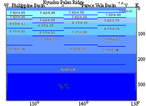
The Velocity Characteristics of the Structural Elements of
the Crust along the Geotraverse
 The features most reliably determined by the DSS method are the
surfaces of Moho and of the basement. The surface of the basement was
identified by the depth where the seismic P-wave velocity changes to
the value of, as a rule, more than 5.5 km/s. The thickness of the
crust changes from 4 to 9 km. The lower values characterize the West
Philippine Basin and Mariana Trough. The depth of the Moho surface
changes from 8 to 14 km. The crust is composed of the
sedimentary-volcanogenic layer with a thickness of 1.2 to 3.5 km, and
the consolidated lower layer of 2.8 to 6.6 km thickness. The V p
values for the crust as a whole change along the Geotraverse
from 5.1 to 6.0 km/s; lower values refer the ridges, higher values
characterize basins.
The deep structure of the Philippine Sea Geotraverse reveals the
following features:
The features most reliably determined by the DSS method are the
surfaces of Moho and of the basement. The surface of the basement was
identified by the depth where the seismic P-wave velocity changes to
the value of, as a rule, more than 5.5 km/s. The thickness of the
crust changes from 4 to 9 km. The lower values characterize the West
Philippine Basin and Mariana Trough. The depth of the Moho surface
changes from 8 to 14 km. The crust is composed of the
sedimentary-volcanogenic layer with a thickness of 1.2 to 3.5 km, and
the consolidated lower layer of 2.8 to 6.6 km thickness. The V p
values for the crust as a whole change along the Geotraverse
from 5.1 to 6.0 km/s; lower values refer the ridges, higher values
characterize basins.
The deep structure of the Philippine Sea Geotraverse reveals the
following features:
- the Mariana Trough has lower velocity values in the
uppermost mantle, smaller depth in the M boundary, higher velocities
in the sedimentary-volcanogenic layer and lesser thickness;
- the crust of the basins of the Philippine Sea is almost
identical to the typical oceanic crust.
Upper Mantle
The upper mantle section of the Geotraverse was
constructed based on the consideration of geological, tectonic,
seismological, geothermal, and electromagnetic information.
The Pacific plate (except the area of the Magellan Seamounts)
within the limits of the Geotraverse can be characterized by
parameters that are typical of old oceanic regions. The area of the
Magellan Seamounts seems to be more active.
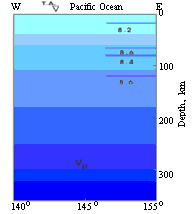
The Upper Mantle Seismic Sections along the Geotraverse
At a depth of about 80 km beneath the Magellan Seamounts, a layer
with reduced P-wave velocity (V p = 8.4 km/s) and with a
thickness of about 40 km has been identified (
Asada and Shimamura, 1976 ).
The upper mantle under the Mariana Trough is reported to have
anomalously low seismic wave velocity (
Seekins and Teng, 1977 ;
Bibee et al., 1980 ).
The top of asthenosphere may be at the depth of about 10-15 km or
even less under the Mariana Trough (
Uyeda, 1982 ).
The seismic structure of the Parece Vela Basin has been studied by
the surface wave method (
Abe and Kanamori, 1970 ;
Seekins and Teng, 1977 ;
Shiono et al., 1980 ).
According to these studies, the top of the asthenosphere is located at
a depth of about 30 km. Simple deep temperature calculations indicate
that 1000 o C isotherm under the Parece Vela rift lies at
about this depth (
Rodnikov et al., 1991 ).
In the upper mantle of the West Philippine Basin, a layer of low
velocity occurs at a depth of 50 km (
Shiono et al., 1980 ).
From inversion of geomagnetic field variations, a layer of high
electrical conductivity (0.5 S/m) was suspected to be at a depth of
80-100 km (
Honkura et al., 1981 ).
Considering the resolving power of the method used, this result may be
considered to be in harmony with the seismic result; in fact, in a
recent model the depth is reduced to 60 km (
Shimakawa and Honkura, 1991 ).
On the basis of the above information, we conclude that the
thickness of the seismological lithosphere is about 50 km beneath the
West Philippine Basin, about 30 km beneath the Parece Vela Basin, and
about 10 km beneath the Mariana Trough. Based on the bathymetry and
seismic profiles data, evaluations of the thickness of the elastic
lithosphere in the characteristic points along the Geotraverse (
Rodnikov et al., 1991 )
showed generally less thickness, i. e., about 50km beneath the Pacific
plate, about 45 km beneath the West Philippine Basin, about 20 - 25 km
beneath the Parece Vela Basin and about 15 km beneath the Mariana
Ridges. Using the present deep-temperature calculations it is possible
to infer that the bottom of the elastic lithosphere seems to
correspond to a temperature of 650-800 o C, whereas the
bottom of the seismic lithosphere appears to correspond to a
temperature of about 1000 o C.
Concluding remarks
Within a Russian-Japan cooperative framework, the Philippine
Sea Geotraverse Project has produced a set of
bathymetric, magnetic, gravity and geological maps and
a geological-geophysical cross-section to a depth of 100 km along
the 18 o N latitude from the Magellan Seamounts in the
western Pacific to the West Philippine Basin. A comprehensive
interpretation of the available geological-geophysical data has been
carried out along the length of the Geotraverse.
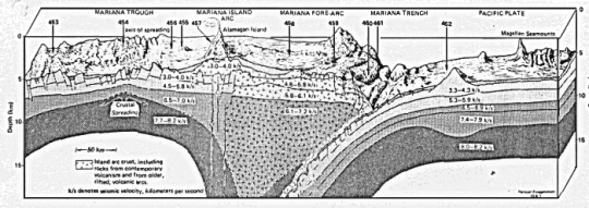
Deep Geological-Geophysical Cross-section along the
Philippine Sea Geotraverse
More detailed view of the
Deep Cross-section
 The profile cuts across oceanic structures of various ages: the
Mesozoic Pacific Ocean, the Pliocene-Pleistocene Mariana Trough, the
Oligocene-Miocene Parece Vela Basin, and the Eocene West Philippine
Basin. The profile intersects rift structures in the Mariana Trough
and the Parece Vela Basin. Seismological studies have revealed a low
velocity layer that may be identified as the asthenosphere. In the
areas of rift structure, the top of asthenosphere shallows
significantly and in the basinal areas, the depth of the top of
asthenosphere deepens with the age of crust as is the case for normal
oceans, reflecting a distinct correlation between processes in the
upper mantle and surface structures (
Rodnikov, 1988 ).
Several issues remain to be solved in the future. The first is
that the basement depth of the basins of the Philippine Sea is
systematically deeper by about 800 m than the normal oceans with the
same age (
Park et al., 1990 )
whereas the heat flow - age relation is practically the same with that
of the normal oceans (
Yamano and Uyeda, 1988 ).
It can be suggested that the depth anomalies in the marginal seas may be
related with the distribution of depth anomalies that are dynamically
supported by the global mantle convection. The sea depth anomaly would
be connected also with the subducted slab materials stored near the
upper-lower mantle boundary and in the lower mantle. What mechanism is
responsible for the mentioned depth anomaly and whether this anomaly
is related to the structures and processes specific to the marginal
seas or to the global scale processes will have to be clarified.
The second is that the upper mantle electrical conductivity is
reported to be higher under the Eocene West Philippine Basin (
Shimakawa and Honkura, 1991 )
than under the actively spreading Mariana Trough (
Filloux, 1983 ).
The third one is related to the upper mantle temperature. Except
for the above mentioned Western Pacific Basin, the 1000 o
C isotherm seems to coincide with the top of the seismologically
identified asthenosphere . If this is the case, its consequence may be
of some importance. It is often considered that the solidus
temperature of dry ultramafic rocks of about 1200 o C
would be the temperature at the lithosphere-asthenosphere boundary. If
the asthenosphere is composed of partially molten ultramafic rocks,
existence of abundant water at the depth would be required to lower
the solidus to 1000 o C (
Kushiro et al., 1968 ).
Alternatively, seismological asthenosphere may not require partial
melting. Through inversion of numerous seismic and free oscillation
data, taking account of the attenuation factor Q and the anisotropy of
seismic wave velocities in the upper mantle,
Dziewonski and Anderson (1981)
introduced the Preliminary Reference Earth Model ( PREM ) which shows
that globally the velocity decrease in the upper mantle low velocity
layer is much reduced.
Kawasaki (1986) ,
with a similar approach, obtained a model of the oceanic upper mantle,
according to which the thickness of the lithosphere is also much
reduced (to about 50 km). It has been suggested that solid state
anelasticity can provide reasonable explanations to such a velocity
structure of the upper mantle and its mechanical properties such as
viscosity (e. g.
Karato and Spetzler, 1990 ).
We would like to emphasize that in order to solve any of these
problems, many more reliable data must be acquired and at the same
time more realistic time dependent and three dimensional temperature
models have to be developed, taking full account of such factors as
the heat sources and sinks, pressure-temperature dependence of thermal
conductivities of the media and non-conductive heat transfer
mechanisms that can carry out by involvement of both solid and fluid
phases.
Finally, we would like to mention again that, with the
participation of Chinese scientists, the Philippine Sea Geotraverse
was later extended west and northwestward across the Ryukyu arc, East
China Sea to the North China Plain. Results of the extended
Geotraverse will be published elsewhere in near future although some
initial results have already been reported by
Rodnikov et al., 1991 .
The profile cuts across oceanic structures of various ages: the
Mesozoic Pacific Ocean, the Pliocene-Pleistocene Mariana Trough, the
Oligocene-Miocene Parece Vela Basin, and the Eocene West Philippine
Basin. The profile intersects rift structures in the Mariana Trough
and the Parece Vela Basin. Seismological studies have revealed a low
velocity layer that may be identified as the asthenosphere. In the
areas of rift structure, the top of asthenosphere shallows
significantly and in the basinal areas, the depth of the top of
asthenosphere deepens with the age of crust as is the case for normal
oceans, reflecting a distinct correlation between processes in the
upper mantle and surface structures (
Rodnikov, 1988 ).
Several issues remain to be solved in the future. The first is
that the basement depth of the basins of the Philippine Sea is
systematically deeper by about 800 m than the normal oceans with the
same age (
Park et al., 1990 )
whereas the heat flow - age relation is practically the same with that
of the normal oceans (
Yamano and Uyeda, 1988 ).
It can be suggested that the depth anomalies in the marginal seas may be
related with the distribution of depth anomalies that are dynamically
supported by the global mantle convection. The sea depth anomaly would
be connected also with the subducted slab materials stored near the
upper-lower mantle boundary and in the lower mantle. What mechanism is
responsible for the mentioned depth anomaly and whether this anomaly
is related to the structures and processes specific to the marginal
seas or to the global scale processes will have to be clarified.
The second is that the upper mantle electrical conductivity is
reported to be higher under the Eocene West Philippine Basin (
Shimakawa and Honkura, 1991 )
than under the actively spreading Mariana Trough (
Filloux, 1983 ).
The third one is related to the upper mantle temperature. Except
for the above mentioned Western Pacific Basin, the 1000 o
C isotherm seems to coincide with the top of the seismologically
identified asthenosphere . If this is the case, its consequence may be
of some importance. It is often considered that the solidus
temperature of dry ultramafic rocks of about 1200 o C
would be the temperature at the lithosphere-asthenosphere boundary. If
the asthenosphere is composed of partially molten ultramafic rocks,
existence of abundant water at the depth would be required to lower
the solidus to 1000 o C (
Kushiro et al., 1968 ).
Alternatively, seismological asthenosphere may not require partial
melting. Through inversion of numerous seismic and free oscillation
data, taking account of the attenuation factor Q and the anisotropy of
seismic wave velocities in the upper mantle,
Dziewonski and Anderson (1981)
introduced the Preliminary Reference Earth Model ( PREM ) which shows
that globally the velocity decrease in the upper mantle low velocity
layer is much reduced.
Kawasaki (1986) ,
with a similar approach, obtained a model of the oceanic upper mantle,
according to which the thickness of the lithosphere is also much
reduced (to about 50 km). It has been suggested that solid state
anelasticity can provide reasonable explanations to such a velocity
structure of the upper mantle and its mechanical properties such as
viscosity (e. g.
Karato and Spetzler, 1990 ).
We would like to emphasize that in order to solve any of these
problems, many more reliable data must be acquired and at the same
time more realistic time dependent and three dimensional temperature
models have to be developed, taking full account of such factors as
the heat sources and sinks, pressure-temperature dependence of thermal
conductivities of the media and non-conductive heat transfer
mechanisms that can carry out by involvement of both solid and fluid
phases.
Finally, we would like to mention again that, with the
participation of Chinese scientists, the Philippine Sea Geotraverse
was later extended west and northwestward across the Ryukyu arc, East
China Sea to the North China Plain. Results of the extended
Geotraverse will be published elsewhere in near future although some
initial results have already been reported by
Rodnikov et al., 1991 .
URL:
http://www.wdcb.ru/sep/traverses/Philippine_Geotraverse/text.html
2001-2016 © WDC for SEP,
GC RAS
webmaster
|