Geophysical Center of the Russian Academy of Sciences, Moscow, Russia
World Data Center for Solid Earth Physics
The Geotraverse Project
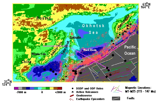
The Okhotsk Sea Geotraverse

Explanatory Note
Introduction
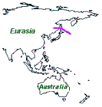
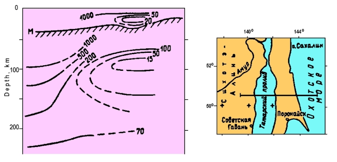
Location of the Okhotsk Sea Geotraverse
Geology
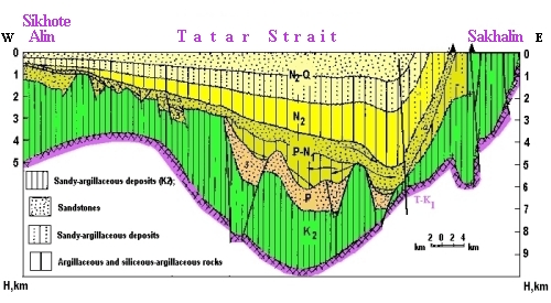
Tatar Strait
The Tatar Strait is a large trough - graben composed of a thick layer (up to 8 - 10 km) of Mesozoic - Cenozoic sedimentary formations ( Tronov et al., 1987 ; Khvedchuk, 1992 ; Varnavsky, 1994 ). It is situated between the Mesozoic structures of Sikhote Alin and the Western Sakhalin Mountains, from which it is divided by deep faults. According to the available geological – geophysical data, the sediments filling the trough form four structural complexes divided by regional stratigraphic un conformities and differing by the structural and physical characteristics; i. c. Upper Cretaceous, Paleogene, Oligocene - Lower Miocene and middle Miocene – Quaternary
Geological - Geophysical Section of the Tatar Strait Trough ( Structure ..., 1996 )
Sakhalin
The polygon of the Sakhalin geotraverse starts in the area of the Isthmus of Vetrovoi and in the north crosses the East Sakhalin Mts and in the south the Susunai Ridge. The structure of the island includes metamorphic, magmatic and sedimentary rocks ranging from the Paleozoic to Recent. The oldest rocks were observed in the East Sakhalin Mts. and on the Susunai Ridge. They are composed of serpentinized ultrabasites and metamorphic shales with jasper, quartzite and marble interbeds and change over to quartzites, green shales, metaspilites and metadiabases in the upper part of the section ( Rihter, 1986 ).
Seismogeological Model of the Eastern Zone
of the Central and Southern Sakhalin
( Bikenina et al., 1987 )
The Sea of Okhotsk
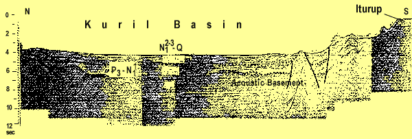
In the Sea of Okhotsk, the geotraverse crosses Terpeniya Bay and the Kuril Basin.
Seismic Profile Across the Kuril Basin of the Sea of Okhotsk
( Structure..., 1996 )
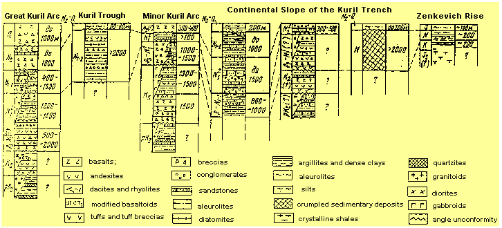
The Kuril Island Arc
The geotraverse runs within the Great Island Arc in the region of the Iturup Island and crosses the Lesser Island Arc and the Kuril Trench. The description of the geological structure is represented according to the following publications ( Rodnikov, 1968, 1973, 1979 ; Belyaevsky and Rodnikov, 1972 ; Sergeev, 1976 ; Geology - Geophysical ..., 1987 ; Vasiliev, 1988 ; Zlobin, 1989 ; Piskunov, 1987 ; Frolova et al., 1989 ; Krasny, 1990 ; Pushcharovsky and Melankholina, 1992 ; Avdeiko et al., 1992 ). Within the Kuril Island Arc there are the Great Island Arc, the Inter - Arc Trough, the Lesser Island Arc and the Kuril Trench. The geological structure of the enumerated structures is shown below.
Correlation Scheme of Sections of the
Major Tectonic Structures of the Kuril Island Arc
( Vasiliev, 1988 )
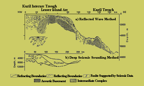
Seismic Section Across the Minor Kuril Arc ( Snegovskoi, 1974 )
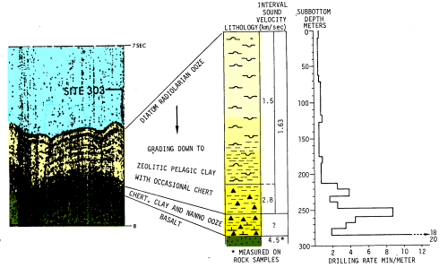
The North West Pacific Basin
The geotraverse runs within Zenkevich Rise and a vast plain stretching eastward to Shatsky Rise with average depths of 5000 - 5500 m. Zenkevitch Rise is a marginal oceanic uplift separated from an isobath of 5500 m which is 300 - 350 m wide and is 200 - 400 m above the ocean floor ( Structure of the floor..., 1984 ). The thickness of sediments is insignificant (300 - 350 m) and the oceanic crust second layer rocks composed of tholeiite basalts ( Tectonics..., 1983 ). When dredged, besides basalts fragments of tuffs, aleurolite, graywacke, argillite, siliceous rocks, metaschists, andesites, diabases, porphyry, granodiorite, granites, and aplites were lifted ( Vasiliev, 1988 ). The age of the dredged basalts from the outcrops of the acoustic basement is in the range of 80.1 - 32.6 million years ( from the Late Cretaceous to the Oligocene inclusive ), and the age of granodiorites is 103 million years (The Early Cretaceous).
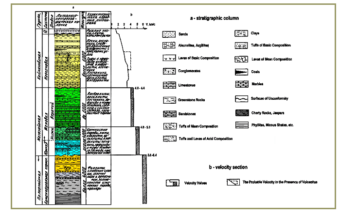
Correlation of Seismic Reflection Profiles with
Drilling Results at Site 303
( Larson et al., 1975 )
The Crust
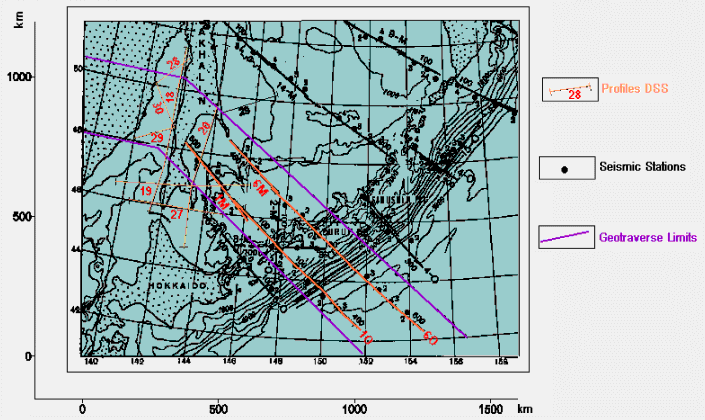
Map of Location of Deep Seismic Sounding Profiles at the Geotraverse Region
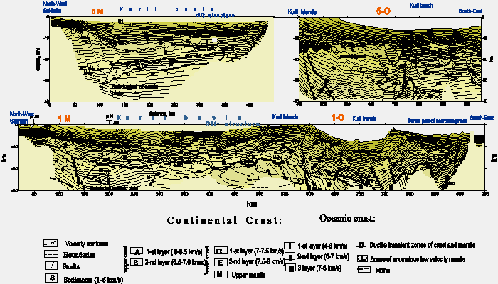
Seismic Cross-section of the Crust along the Geotraverse ( Piip V.B. )
Geophysical Investigations
Geothermal studies of deep structure
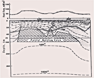
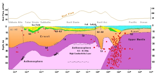
Distribution of Heat Flow Values (in mW/m 2 ) along the Geotraverse
The heat flow variations within the Sikhote Alin reach only 39 - 56 mW/m 2. Near the Kuril part of the Pacific Ocean the average heat flow values are 52 mW/m 2.
Deep Temperatures along the Geotraverse
( Structure ..., 1996; )
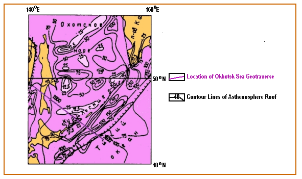
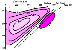
The deep temperatures on the Moho boundary vary from 100o C in the Pacific Ocean to 1000 o C below the Tatar Strait Trough. Under the Kuril basin with a thin crust they reach 800 o C. The depth to the roof of the partial melting area, identified as the asthenospheric layer of the upper mantle (isotherm 1100 o C, according to Ya.B. Smirnov, and 1200 o C, according to I.K. Tuezov and V.D. Epaneshnikov ( Structure ..., 1996 )) along the geotraverse varies from 25 km to 100 km. The area of partial melting forms two asthenospheric diapirs, i. e., under the Tatar Strait and the Kuril Basin, thus causing an active tectonic regime manifested in the volcanic and seismic activity. Moreover, above the asthenospheric diapir in the Tatar Strait the hydrocarbon deposits were recorded in the sedimentary layer, and in the Kuril basin a sulfide mineralization was established on the tops of the submarine volcanoes ( Kononov, 1989 ). The volcanoes are composed of the Pliocene - Quaternary basalts, andesites, and dacites. Sulfide mineralization coincides with the summits of submarine volcanoes. The prevailing mineral is pyrite. Also marcasite, pyrhotite, and chalcopyrite are encountered. Thus, the maximal temperatures and the minimal thickness of the lithosphere are typical of deep water basins of the Sea of Okhotsk. In the axial parts of these structures the asthenospheric layer rises up to 25 km and probably even to 10 km (under the interarc trough); on the flanks it sinks to the depths of 40 - 50 km, whereas under the Pacific Ocean it reaches the depth of 100 km.
Scheme of Depths of Deposition of the
Asthenosphere under the Sea of Okhotsk
( Structure..., 1996 )
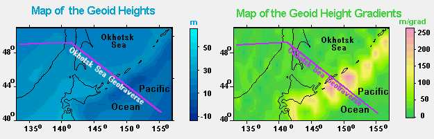
Gravity Field
The main features of the deep structure of the Okhotsk Geotraverse area can be seen also from the field of the geoid heights. To make the regional features (smaller spatial size) of the deep density structure of the region more easy visible we construct the field of the gradients of the geoid heights. Lower degrees up to 15 power spherical harmonics are removed to make the regional structure more easy visible.
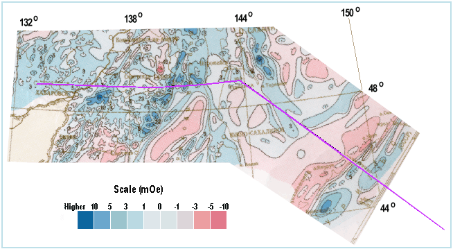
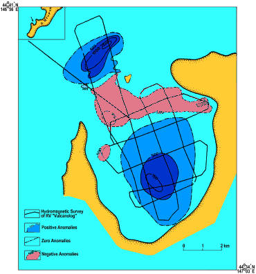
The Magnetic Field
The anomalous magnetic field of the Okhotsk Sea region along the geotraverse is characterized by anomalies with differently oriented elongations of various configurations and values. ( Structure..., 1996 ). Most of the observed magnetic field anomalies are linearity elongated in the north - western and north - eastern directions.
Anomal Magnetic Field of the
Okhotsk Sea Region
( Makarova and Shmiyarova, 1978 )
Magnetic field (DT)
in the geotraverse zone of the Okhotsk Sea in the area of the Kuril Islands
generally has a negative background complicated by the magnetic field
effects of submarine magnetic constructions.
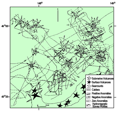
Anomal Magnetic Field (DT) in the Area of the Iturup Island
Anomalous Magnetic Field of the Caldera "Lvinaya Past'" (Iturup Island)
Electromagnetic studies of the deep structure
The results of magnetotelluric sounding within the Sikhote - Alin' area ( Nikiforova et al., 1980 ). have shown that the conducting layer, i.e. the asthenosphere, lies in the upper mantle at the depth of about 120 km below the eastern part of Sikhote - Alin', and its depth grows to the west and reaches 220 km.
Geoelectric Structure under the Transition Zone ( Van'yan and Shilovskii, 1983 )
Along the geotraverse in the Kuril basin of the Sea of Okhotsk the electromagnetic research was carried out by applying the method of the gradient magnetovariation sounding ( Lyapishev et al., 1987 ). According to the selected geoelectrical model, a layer with specific conductivity of 0.3 - 0.5 Sm/m and integral conductivity about 15000 Sm was located in the upper mantle within the 30 - 65 km depth interval.
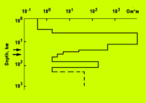
Geoelectric Model beneath the Kuril Basin
( Lyapishev et al., 1987 )
The nature of the layer is associated with partial melting, and its distribution is confined to the limits of the basin. At the depth of more than 100 km, a second conductivity layer can be identified ( Lyapishev et al., 1987 ) The obtained results correlate with deep temperatures in the upper mantle, with seismic research, and other geophysical data.
The Upper Mantle
The Upper Mantle is characterized by both horizontal and considerable vertical heterogeneities. From data on deep - focus earthquakes, V.N. Burmin ( Burmin et al., 1992 ) constructed the velocity section of the upper mantle.
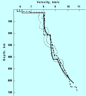
Distribution of the P - wave Velocity
in the 0 - 700 km Depth Range
( Burmin et al., 1992 )
On the whole, the velocity curve of the Okhotsk Sea upper mantle
approximates the velocity curve for the standard model of the Earth,
but in the depth range of 220 km to 600 km the velocity of seismic
waves propagation is lower than the average for the Earth. Wave
guides are missing from the Okhotsk Sea upper mantle
( Burmin et al., 1992 )
Below the recent volcanism zones of the Kuril Island Arc, low - velocities
zone is revealed to the depths of 150 - 250 km
( Fedotov and Kuzin, 1963;
Boldyrev and Kats, 1982 ).
In this area local magmatic centers appear that supply numerous volcanoes
of the Kuril Island Arc. On the whole, the upper mantle below the Sea
of Okhotsk is slightly less dense as compared with the Pacific
( Boldyrev et al., 1993 )
Scheme of Distribution of Density Anomalies
(in g/cm3) in the Upper Mantle under
the Okhotsk Sea Region
( Boldyrev et al., 1993 )
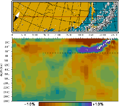
Tomograph Structure along Okhotsk Sea
Geotraverse
( Bijwaard )
Deep Temperature Distributions along the Sea of Okhotsk ( Smirnov and Sugrobov, 1982 )
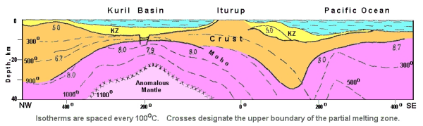
The anomalous mantle in the upper mantle beneath the Kuril Basin is apparently a rising asthenospheric diapir. Its upper part forms a partially melting zone ( Tuezov, 1975 ) where primary magmatic reservoirs are formed. Thus maximal temperatures and minimal thicknesses of the lithosphere are characteristic of deep basins like the Kuril Basin and Tatar Strait Trough. The asthenosphere there rises up to 20 km. The lowest temperatures and the greatest thickness of the lithosphere are established within the northwestern area of the Pacific. Models of tectonosphere density constructed by different authors ( Anomalous..., 1974; Sychev, 1979; Krasny, 1990 ) also demonstrated that under the deep basins of the Okhotsk Sea the asthenosphere of increased thickness is found. Residual mantle anomalies obtained by excluding gravity affects of the crust from the observed values of gravity field are close to zero above the oceanic basins, are positive above Kuril Trench, and are negative above deep basins. High heat flow and mantle thinning may be associated with the rise of the lighter and hotter anomalous mantle, i.e. asthenosphere.
Geodynamic Investigations
Seismicity
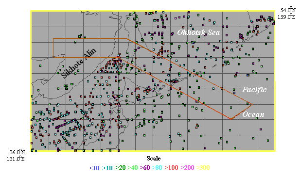
Distribution of Earthquake Epicenters in the Region of Geotraverse
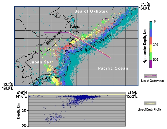
Depth Distribution
of 2756 Earthquake Hypocenters along the Okhotsk Sea Geotraverse
in 2o Zone
according to the World Earthquake Catalog PDE
for the period 1904 - 1999
The location of the Okhotsk Sea Plate in the contact area of the three lithospheric plates: Eurasian, North American and Pacific caused high seismicity on its margins. The highest seismicity is noted along the Kuril island arc. The Pacific Plate there subsides under the continent, forming a seismofocal zone which is traced to the depth of 600 km. In the west the Okhotsk Sea Plate is bounded by deep faults extending along Sakhalin. Earthquakes there are mostly located in the crust.
Let us consider some issues of geodynamic conditions of two disastrous earthquakes in the South Kuril Islands in 1994 and in Sakhalin in 1995.
Section of Tectonosphere across the Kuril Island Arc at the Area of Shikotan Earthquake
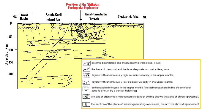
The center is oriented along the island arc. A displacement in it is a dextral strike - slip fault ( E.A. Rogozhin, 1996 ).
The Recent Volcanism
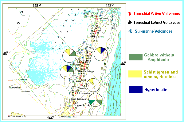
The characteristic feature of the Kuril island arc is the high tectono - magmatic activity manifested on the surface by recent volcanism and seismicity. There are 105 land volcanoes on its territory, 42 of which are active, the others are of Quaternary age, and 96 submarine volcanoes ( Avdeiko et al., 1992 ). The part of the geotraverse, covering the three islands Kunashir, Iturup and Urup, has 34 land volcanoes (16 of which are active) and 23 submarine volcanoes.
Distribution of Kuril Islands Volcanoes ( Fedorchenko and Rodionova, 1987 )
In the course of this century more than 100 eruptions of different
strength and types were recorded on the Kuril Is.
( Gorshkov, 1967 ).
The products of eruptions form a number of calc - alkalic rocks ranging
from basalts to dacites and rhyolites. The content of alkalic metals
(mainly potassium) grows with the distance from the ocean thus reflecting
the manifestation of the petrochemical zoning
( Fedorchenko and Rodionova, 1987 ).
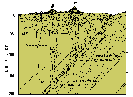
Model of Magma Formation
( Avdeiko, 1994 )
According to the data presented by G.P. Avdeiko ( Avdeiko, 1994 ), the magma under the Kuril arc is generated in the mantle wedge over the subduction zone where the earthquake foci are concentrated, which under effect of the volatile substances are separated from the subducting plate of the Pacific Ocean. At the initial stage of the oceanic plate subduction, the water in the sediments and in the pores and fissures of magmatic rocks is separated. It emanates at temperatures more than 100o C and at the depths of about 30 - 40 km. This water is used for the formation of metamorphic rocks. At large depths, in the 200 - 700 km interval, the water containing minerals are dehydrated, and the fluid solution is formed thus lowering the temperature of rock melting.
Conclusions
The geotraverse of the Okhotsk Sea area demonstrates the tectonosphere structure to a depth of 100 km.
The Okhotsk Sea Geotraverse
The crustal thickness ranges from 35 - 40 km under Sakhalin and the Kuril Islands to 10 km under the Kuril Basin. The asthenosphere forms diapir under the Kuril Basin and Tatar Strait Trough. Rifts, spreading structures are located in the base of these structures. The initial stage of the Kuril Basin formation and Tatar Strait Though is associated with magma extension and intrusion. The asthenospheric diapirs rising toward the crust caused high heat flow. The formation of Tatar Strait Trough is related to the extending northward spreading center found in the deep basin of the Japan Sea. The formation of the Kuril Basin is also related to spreading processes taking place in the Late Cretaceous. The formation of the Interarc trough dividing the Kuril Islands arc into the Larger and the Smaller ones is also related to spreading.
Top of the Document | Main Page
URL: http://www.wdcb.ru/sep/traverses/Okhotsk_Geotraverse/text.html2001-2016 © WDC for SEP, GC RAS webmaster