 Ěŕňĺđčŕë 2.
Aeromagnetic Survey Across Crater Flat and Yucca Mtn
INTRODUCTION
 An aeromagnetic survey was flown by the U.S. Geological Survey (USGS) over Crater
Flat and part of Yucca Mountain, Nevada, to help in the interpretation of the
subsurface geologic structure at a potential location of a nuclear waste repository.
The USGS airplane was in the Yucca Mountain vicinity to fly an extensive
aeromagnetic and VLF survey of the Beatty area just to the west. The lines reported
here followed the trace of a proposed seismic profiles across Crater Flat and Yucca
Mountain.
An aeromagnetic survey was flown by the U.S. Geological Survey (USGS) over Crater
Flat and part of Yucca Mountain, Nevada, to help in the interpretation of the
subsurface geologic structure at a potential location of a nuclear waste repository.
The USGS airplane was in the Yucca Mountain vicinity to fly an extensive
aeromagnetic and VLF survey of the Beatty area just to the west. The lines reported
here followed the trace of a proposed seismic profiles across Crater Flat and Yucca
Mountain.
Magnetic surveys are used to help locate and identify the sources of anomalies in the
Earth's magnetic field. Magnetic anomalies may be related to near-surface geology or
to geologic structural features within the Earth's crust. Magnetic data may reveal
the existence of faults, the distribution of stratigraphic units, the presence of
intrusive bodies, the thickness and shape of sedimentary basins, and the depth to the
bottom of magnetic sources. Magnetic anomalies will tend to form along boundaries
where there is a vertical offset of beds.
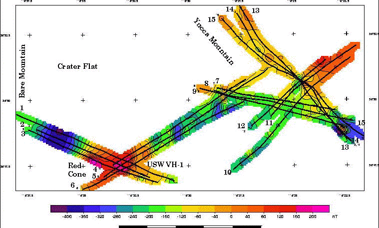
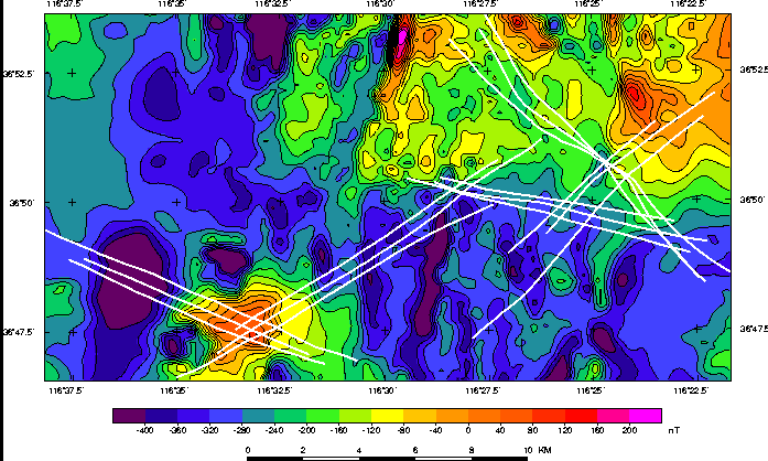
The gridded and contoured aeromagnetic survey data (fig.1) show a number of magnetic
features that can also be seen on a detailed aeromagnetic map (fig. 2) of the Timber
Mountain area. A broad magnetic low in the western third of profiles 1, 2, and 3 may
be due to reversely magnetized tuffs. These tuffs are Miocene in age and consist of
quartz- and hornblende-bearing rhyolitic ash-flow tuffs (Carr and others, 1986).
However, this anomaly may be related to a reversely magnetized basalt flow that was
penetrated in drill-hole USW VH-2 (Carr and Parrish, 1985).
 (Click on image for a full-size version, 75 Kbytes.)
Aeromagnetic map along seismic reflection lines across Crater Flat and Yucca Mountain.
Red colors, magnetic highs; blue colors, magnetic lows.
A broad magnetic high occurs just south of Black Cone, on profiles 1, 2, and 3 and 4,
5, and 6 (fig. 1). The source of this high is unknown but may be due to buried normally
magnetized volcanic rocks if they thicken towards the center of the anomaly. A hole
drilled over this anomaly revealed about 300 m (984 ft) of Topopah Spring Tuff of the Paintbrush Group and over 140 m (459 ft) of densely welded Bullfrog Member of the Crater
Flat Tuff. Both of these units have magnetic properties that could cause the anomaly. Physical property measurements show that both these units are normally magnetized.
A deep north trending low in the middle of lines 4, 5, and 6 is ascribed by Kane and
Bracken (1983) to a possible offset in underlying horizontal tuffs. Magnetic highs
over Yucca Mountain, at the northeast end of lines 10,11, and 12 and the northwest
on two-thirds of lines 13, 14, and 15, generally correlate with exposures of the
Topopah Spring Tuff of the Paintbrush Group(Sawers and others, 1994). Linear magnetic
features in this area may reflect offsets in flat-lying volcanic units. Such offsets may
only represent lithologic causes, such as variations in thickness or magnetic properties
of the volcanic units, or they could be due to tectonic elements, such as faults. Joint
interpretation of these data together with seismic and other data still to come should
help resolve the nature of these possible offsets.
 (Click on image for a full-size version, 43 Kbytes.)
Aeromagnetic map of the Timber Mountain survey.
Red colors, magnetic highs; blue colors, magnetic lows.
See the article: Sikora, R.F., Campbell, D.L, and Kucks, R.P., 1995, Aeromagnetic
surveys across Crater Flat and part of Yucca Mountain, Nevada: U.S. Geological Survey
Open-File Report 95-812, 13 p. Available from the USGS--Information Services,
Box 25286, Bldg. 810, Denver Federal Center, Denver, CO 80225 303 236-4210.
Bob Sikora, Geophysical Unit of Menlo Park, U.S. Geological Survey, MS 989, 345 Middlefield Rd., Menlo Park, CA 94025 E-mail to sikora@mojave.wr.usgs.gov