Plate Boundary Processes
Local and regional departures from rigid plate behavior occur along interplate boundaries and within domains of intraplate deformation. Where plate boundary deformation involves continental lithosphere, it is commonly distributed over complex networks of faults and folds up to several thousand kilometers wide, with zones of intense deformation along the margins of less deformed crustal fragments of dimensions from ten to hundreds of kilometers. This spatial complexity is demonstrably tied to temporal variations in the pattern of motions. In contrast to global plate motions, the complex history of deformation within regions of plate boundary interaction and intraplate deformation is known in most areas only at the crudest level of detail.Actively deforming subregions are complex laboratories that evolve over time and involve a multitude of interrelated physical and chemical processes. Thus, tectonic analysis of actively deforming subregions requires an integrated approach involving the use and appreciation of diverse data sets. It requires a comprehensive understanding of the nature and distribution of rock units and structures within the crust and lithosphere, an appreciation of the relationship of the subregional tectonic framework to the regional and plate tectonic framework, and finally an understanding of the geological history.
Because it offers the unparalleled means to measure the subregional contemporary strain and rates of deformation as it occurs, GPS can play a major role in the study of contemporary deformation. These include: (1) establishing the recent and present-day displacement field by tracking the changes of position of ground points through time, (2) establishing rates of contemporary vertical and lateral deformation, (3) interpreting how the displacements are partitioned with respect to slip of surface faults, rigid-body rotation, permanent strains, and volumetric strains, (4) interpreting the mechanisms by which the regional deformation is accomplished, (5) tracking how the deformation accrues through time, (6) defining how surface deformation relates to the overall crustal structure, and (7) assessing regions of seismic versus aseismic (dormant) regions of expected earthquakes. Thus, the significant opportunity is to define comprehensively the displacement field(s) through time, including vertical changes, tilts, translations, rotations, and wholesale strains.
Ultimately the "paths" of displacements, viewed collectively, will permit investigators to distinguish among models of crustal/lithospheric deformation. Understanding plate boundary deformation is particularly important because these zones host most of the world's catastrophic earthquakes and volcanoes (Alpine/Himalayan and Pacific Rim). Moreover, the boundaries of plates, if properly understood, are the only locations that can provide us with information on crust-mantle interaction and also provide some of the best insights into lithospheric rheology.
Problems in plate boundary deformation need to be addressed simultaneously at several different levels. First, one needs to map the active strain field within the global plate boundary system, by use of measurements on baselines of perhaps 100 km. Second, one needs to understand how strain is partitioned, in space and time, along zones of high strain that separate less deformed crustal blocks within plate boundaries, and how these high strain zones are expressed geologically. The latter need not, and probably should not, be carried out on a global scale, but may be undertaken in selected regions that are logistically accessible and geologically well expressed. Some examples of outstanding problems in each of these areas might be as follows:
- Where are the regions undergoing rapid rates of lithospheric strain adjacent to and within the relatively rigid plates? What is the width of these zones of distributed deformation, and how is deformation partitioned within them?
- How is slip partitioned between multiple faults within a plate boundary? How do fault zones develop and evolve through time? How are fault zones localized within the crust (for example by pre-existing crustal structures)? What conditions lead to the abandonment of existing fault systems and the development of new ones?
- How is the deformation observed in the upper layers of the Earth expressed at deeper levels in flow of the lower crust and upper mantle? How are vertical axis rotations accommodated at depth?
- How do strain measurements from geodetic observations compare with long-term geologic estimates of deformation? How much plate boundary slip occurs aseismically? How much deformation is not accommodated by slip on faults? How do geodetically determined rates compare to rates of deformation deduced from summation of moments of contemporary seismicity?
Thus the greatest long-term challenge in studies of regional plate boundary deformation is the successful merging of precise geodetic data with other geophysical data and careful geologic mapping to provide the most complete description of how these complex deformation systems reflect motions occurring at depth within the lower crust and mantle, and how they have evolved through time.
Ultimately, we must seek to understand the dynamic processes that drive surface deformation within zones of plate boundary deformation. Thus GPS will provide a more complete foundation to address even more fundamental questions such as:
- What are the driving mechanisms for deformation within a plate boundary, such as boundary conditions imposed by the relative velocities of adjacent plates, potential energy from excess topography and subsurface loads, contributions from local dynamic systems within a plate boundary (e.g. localized subduction boundaries, back-arc systems), and influence of processes in the asthenosphere?
- How are motions in the upper crust coupled to motions in the uppermost mantle? Over what time-scale and length-scale are these motions coupled? How does this reflect the rheology of the lithosphere?
Mantle Dynamics and Tibet
At present, techniques for measuring flow within the mantle of a regional scale are not available, but recent work that combines crustal kinematics, gravity data, velocity structure, and theoretical models for fluid convection show promise for the future. The implications for our understanding of mantle dynamics are enormous, as can be illustrated by considering some basic questions about the deformation history of Tibet (Figure 9).
A number of studies suggest that deformation within Tibet involves movement of crustal fragments, with dimensions of tens to hundreds of kilometers, in directions oblique or even orthogonal to the overall direction of convergence between India and Asia. Data from northeastern Tibet show that, on a length scale of tens of kilometers, major deformation has switched from one system of faults to another and from one type of deformation to another over time intervals of less than a million years. If mantle flow beneath Tibet can be linked spatially to the active movements of sizable crustal fragments, then the spatial variability of mantle flow must correspond to the motions of individual crustal fragments (which can be measured using space-positioning techniques), whereas the temporal variability of mantle flow must occur over the same time scale as changes in the direction and rate of movements within the crust (which can be dated using traditional geological techniques and remote sensing data). Alternatively, if mantle flow can be shown to be related to crustal motion only at the scale of the entire plate boundary, then one might suspect that the temporal variability of flow in the mantle corresponds to that of the entire plate boundary zone.
The Pacific-North American Transform Boundary
The plate tectonics paradigm has provided Earth scientists with the conceptual framework with which to understand the kinematic history of and strain rates along plate boundaries such as the Pacific-North American transform. Instead of a single break, the transform is several hundred kilometers wide and composed of hundreds of fault-bounded slivers that have translated, rotated, and deformed over time. Plate circuit reconstructions provide a quantitative upper limit on integrated, long-term shear across this broad transform zone, but provide no details on where and how shear is partitioned across this complex boundary. For example, in southern California the boundary consists of the San Andreas fault system and the newly recognized eastern California shear zone (ECSZ) (Figure 10).
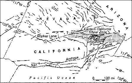
Comparison of the integrated net slip along the ECSZ with motion values across the entire transform boundary indicate that between 9% and 23% of the total relative plate motion has occurred and continues to occur along the ECSZ since its inception in late Miocene time. In this setting, GPS offers the unparalleled opportunity to track the lateral motions of the myriad of fault-bounded blocks that comprise the plate boundary. This powerful tool can also be used to examine the build-up of strain prior to and following major earthquakes, thus providing critical data relating to the formation of earthquakes.
Complexity of Continental Convergence in the Eastern Mediterranean
The Mediterranean region is one of the best documented examples of the spatial complexity found in zones of plate boundary deformation (Figure 11). At the largest scale this region comprises a zone of continental convergence and collision between the slowly moving European and African continents. At every smaller scale, tectonic systems within this broad region exhibit convergent, divergent and strike-slip motions in a large number of different directions.
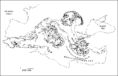
It is not uncommon for very different types of crustal motion and deformation to exist adjacent to one another, such as occurs in the Aegean-Hellenic subduction system in the Eastern Mediterranean where an area of active back-arc extension beneath the Aegean Sea exists adjacent to a zone of shortening and convergence along the Hellenic trench. Geological constraints on the timing and magnitude of extension and thrusting show that there is a close connection between thrusting and extension in space and time, but the detailed kinematic and dynamic relationships between thrusting, extension, and subduction remains poorly understood phenomena.
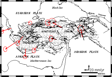
In the complex zone of interaction between the Eurasian, Arabian, and African plates, there is continent-continent collision in eastern Turkey and subduction of the leading edge of the African plate beneath Eurasia along the Hellenic and possibly the Cyprus arcs. GPS observations indicate that western, central, and east-central Turkey is de-coupled from the Eurasian plate and is moving as a more or less coherent unit about an Euler pole located north of the Sinai peninsula (Figure 12). Other space-based measurements of crustal motion in Greece and along the Hellenic arc suggest that this coherent motion includes southern Greece and the south-central Aegean Sea.
Southeast Asia and Indonesia Tectonics
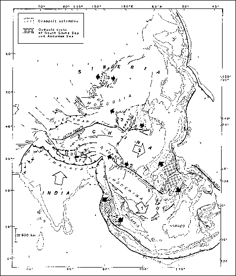
In southeast Asia, four major tectonic plates (Australia, Eurasia, Pacific, and Philippine Sea) interact with each other, mostly along subduction zones (Figure 13). Their present-day kinematics is derived from inversion of earthquake slip vectors along their boundaries as well as transform fault azimuths and ocean floor magnetic anomalies. Within the kinematic frame defined by these four major plates, a broad zone of active crustal deformation covers central and southeast Asia. It extends from the Baikal rift in the north to the Indonesian subduction arc in the south where most of the stress induced by plate motions is released.
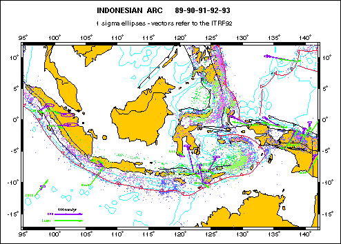
The present-day deformation pattern in southeast Asia combines the effects of the Java, Sumatra, Mariana, and Philippines subductions, as well as the effects of the India-Eurasia (Himalaya-Tibet), Australia-Asia (Banda arc), and Australia-Pacific (New Guinea) collisions. It has been imaged by geological and seismological studies but no direct measurements of the velocity field over the whole area has been proposed so far. GPS is the only existing tool that offers the opportunity to directly measure a regional velocity field for southeast Asia. This result is a critical basis for testing current geophysical models at different spatial and temporal scales, from plate kinematics to intracontinental deformation (Central Asia), plate boundary zone deformation (Indonesian arc), and co-seismic deformation.
In particular, the Indonesian archipelago has many active tectonic processes that result in phenomena such as mountain building, continental accretion, destruction of continents, emplacement of ophiolites, development of subduction zones, arc polarity reversal, and basin closure. Sumatra has been cited as a classic example of oblique plate convergence.
Eastern Indonesia is a region of broad deformation where the continental margins of Australia and Southeast Asia and the oceanic plates of the Pacific and Philippine Sea are coming together at rates of 80 to 110 mm/yr. Plate tectonic concepts do not explain the evolution of Indonesia because deformation is not confined to the edges of well-defined, rigid plates. Eastern Indonesia is at the stage of assembly of crustal elements, both continental and oceanic, that will eventually form a complex mountain belt. The strain field within such deforming regions is a first-order observation that can constrain ideas about the behavior of the crust and upper mantle in mountain building.
Of particular interest is whether the brittle, shallow portion of the lithosphere, which is broken into fault-bounded blocks and produces most of the directly observable effects of tectonics, offers significant resistance to plate motions, or if it merely responds to horizontal shear stresses from a strong, ductile upper mantle. If the latter case holds, then the large-scale deformation of the lithosphere can be represented by a continuum, and the surface faulting has little to do with plate dynamics except in an average sense. An important geological consequence of this view is that the juxtaposition of rock types in mountain belts may be as much a consequence of small local mechanical and geometric irregularities as it is a consequence of plate motions.
The Interior Western U.S. and the Transition to the Stable Plate Interior
Much interest has been focused on the mechanism and mode of Late Cenozoic lithospheric extension of the western U.S. Cordillera encompassing the Basin and Range province, the world's largest region of intraplate continental extension (Figure 14). Tectonic process of the Basin-Range are generally thought to be locally driven, including crust-mantle coupled volcanism; "soft" shear coupling between the stable interior, the San Andreas transform fault, and the Cascadia subduction zone; localized topographic load-induced stresses; and coupling of quasi-plastic flow in the lower crust with surface deformation. Active tectonism of the Basin-Range is directly manifest by extensive earthquakes and large Quaternary fault scarps which occur primarily along its margins. Historically eight large earthquakes, dominated by normal- to oblique-slip, reflect ongoing tectonism that is measurable with GPS.
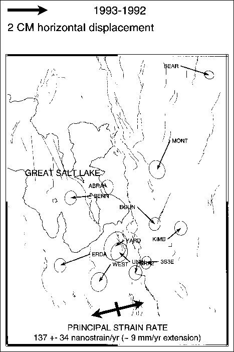
Measurements of contemporary tectonism in the Basin-Range are limited to a few VLBI/SLR ~1000 km baselines which reveal ~1.0 cm/yr of east-west extension. These rates agree remarkably well with displacement rates deduced from summations of seismic moments of historic earthquakes of ~1 cm/yr as well as rates deduced from models of intraplate deformation tied to a fixed mantle framework, and suggest that the brittle mode of deformation accompanying earthquakes accounts for ongoing tectonism. However, little is known of how deformation is distributed across this wide region of extension or of the mechanisms responsible for this unusual style of intraplate deformation.
On a regional scale, VLBI measurements from a single baseline across the Basin-Range transition to the Stable Plate interior compared to the stable U.S. interior give a clue to the lateral distribution of intraplate strain release across the transition between the Basin-Range and stable interior of ~5 mm/yr east-west extension. This rate is remarkably similar to the first GPS measurements against historic trilateration/triangulation data, as well as an annual resurvey of a GPS network across the Wasatch fault, Utah, which revealed 5 to 9 mm/yr northeast extension. This rate notably exceeds the inferred long term ~1 mm/yr rate deduced from Holocene slip determined from paleoseismic measurements. One interpretation of these data is that the now dormant Wasatch fault is storing strain energy at high rate preceding a future earthquake, which has important societal ramifications. However, without further analyses, additional GPS observations, and comparison with older geodetic data these high rates can not be verified.
These observations point out an important problem that can be addressed by GPS: How do rates of contemporary deformation compare with Holocene geologically deduced rates, and do deviations of these contemporary rates indicate short-term processes such as rapid strain accumulation preceding large earthquakes? This question has major implications for the occurrence of earthquakes on known or hidden faults. Low-angle listric and basal detachment faults were first observed in the Basin and Range based upon geologic mapping and seismic reflection data. These observations suggest an important paradox in tectonics, namely the occurrence low-angle normal faults at relatively shallow crustal depths, despite the lack of unequivocal evidence for low-angle faulting from earthquake data. This an important problem which can be addressed using an integrated approach of fault studies, earthquake monitoring, and high-precision GPS measurements.
The widespread seismicity, well-preserved Quaternary faults, and active extension of the Basin and Range thus provide excellent opportunities to evaluate rates of deformation using GPS and such processes questions as "characteristic" earthquakes, space-time clustering of earthquakes and stress coupling between the lower and upper crust, and topographically driven deformation. It is a particularly well-suited region for studying active continental extensional mechanisms with GPS.
Current geologic and geophysical volcano research investigations are examining the origins of magma, the physical and chemical properties of magmas, hydrothermal fluids and gasses, the structure of volcanoes and volcano plumbing, the mechanism of magma transport, and the relationships of volcanoes to tectonic boundaries and earthquakes. GPS measurements of crustal deformation are at the forefront of new techniques for studying these volcanic processes. A better understanding of these processes is contributing to improved volcano hazard assessments and volcano eruption predictions.
Surface deformation measurements offer only the means of constraining the volume and geometry of subsurface crustal magma sources. Traditionally done with trilateration and leveling, precision GPS surveys of ground motion now offer unprecedented simultaneous three-dimensional views of volcano deformation on scales of hundreds of meters to tens of kilometers, and can operate in remote regions not requiring line of sight to observation points. When tied to regional GPS survey networks, a direct measure of the relationship of the volcanic and tectonic framework can also be obtained. Examples of this application are studies of rifting and volcanism in Iceland, investigations of deformation of the Yellowstone caldera and its relationship to a large continental hotspot, and extensive USGS efforts to monitor such active features as Kilauea volcano, Hawaii, and some threatening Alaskan and Cascades volcanoes.
In general, volcano deformation can be separated into two types: that due to roughly equi-dimensional magma chambers and that due to rifting or dike intrusion. From the study of some basaltic shield volcanoes, notably in Hawaii and Iceland, we know that as magma rises from the mantle it collects in shallow magma chambers. As the magma chamber fills, the Earth's surface uplifts and stretches. These inflationary periods are interrupted by eruptions or intrusions into flanking rifts, which cause withdrawal of magma from the chamber and attendant subsidence and contraction.
The earliest models of the inflation-deflation cycle used point centers of dilatation (the so called Mogi source). The surface displacements produced by a Mogi source are nearly indistinguishable from that produced by a spherical magma chamber, and similar to that generated by other equi-dimensional models. It turns out that given only vertical displacement data it is nearly impossible to determine the shape of the magma chamber. Horizontal and vertical data together provide much tighter constraints on source models. One of the benefits of GPS over traditional methods (leveling and trilateration) is that GPS determines all three components of station displacement. Much of the same arguments hold true of rifting. Rifting can occur episodically, accompanied by extensive ground cracking and swarms of shallow earthquakes that migrate downrift at velocities of a few tens of centimeters per second. Examples of volcanic processes are discussed in the following sections.
Interpretations of the crustal deformation data obtained in volcanic studies, such as the studies presented in the following sections, are most meaningful when combined with other geophysical and geologic data. For example, seismicity patterns can be used to locate and identify potential faults related to magma pathways, whereas GPS measures both aseismic and seismic deformation associated with magmatic activity. Combined with precise gravity measurements, GPS and vertical motion observations can also be used to distinguish between changes in elevation due to tectonic strain and changes due to magma flux.
Hazards from volcanic events range from local phreatic (hot water and steam) blasts and lava flows to large catastrophic ash flows and air falls. Volcanic eruptions also produce secondary flooding and landslides. The long-term effects of volcanic eruptions are well known to effect globe-scale weather changes resulting from ash particulates deposited in the atmosphere. The primary goal of volcanic risk research, however, is to specify the timing and locations of potential volcanic eruptions. The location and long-term history of volcanoes are generally known from geologic and historical records. However, it is difficult to determine the short-term timing, style, and volume of an eruption at times scales of a few minutes to hours.
The success of detailed earthquake monitoring in predicting the recent eruptions of Mt. Pinatubo, Philippines, and Mt. Redoubt, Alaska, saved thousands of lives and points out the use of geophysical tools to forecast eminent eruptions. This class of research will benefit by parallel efforts in deformation monitoring for inflation and deflation of the surface which are associated with magma or hydrothermal fluid movements, to constrain the geometry and volume of magma chambers, plumbing of conduits, dikes and sills and associated faulting, and to assess incipient earthquake triggering.
Repeated GPS surveys taken over months and years give insight into the long-term deformation signal associated with volcanic processes. High precision static GPS surveys can be used where deformation rates may only be mm/year. In many cases however, the sequence of eruptive activity can take only hours to days and rates accompanying deformation are cm/hour. Deformation can be continuously monitored with GPS receivers deployed at remote sites and with data transmitted to a central recording site where processing can be done in near real-time kinematic differential modes.
Orbit information broadcast directly from the GPS satellites are sufficient for analyzing short baselines (~10 km), but where receivers are separated by large distances (>10 km), more precise satellite orbits are required for real-time processing. The U.S. Geological Survey is currently operating a small continuous tracking GPS network on St. Augustine volcano in Alaska and will install a network in Hawaii. Monitoring is more effective where augmented with repeated static surveys which can cover additional sites over a larger area and which can be used to determine spatial coherence of the deformation signal over longer time intervals.
New techniques are being developed to make remote sensing measurements of deformation using aircraft. For example, in an experiment at the Long Valley caldera in California, repeated aerial laser altimeter measurements are being made which will be used to produce an image of ground motion. Kinematic GPS is used for precise, centimeter-level positioning of the aircraft. Radar interferometry can detect map surface displacements at the centimeter level of horizontal accuracy, but requires GPS to control the coordinates of satellite images. Similarly, radar interferometry from space is likely to have much potential in observing deformations associated with volcanic activity, but likewise will require GPS calibration on the ground. These remote sensing methods not only have the potential to cover large and possibly remote areas, but also do not require observers to be physically located on a potentially hazardous volcano.
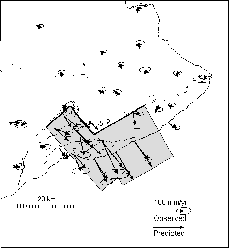
Deformation and seismicity data demonstrate that magmatic activity and slip on Kilauea's fault systems, including the subhorizontal faults that generated the magnitude 7.2 1975 Kalapana earthquake, are coupled. Yet the subsurface geometry of these faults and the deep structure of Kilauea's rift zones are poorly understood. Figure 15 shows the average station velocities for the three-year period with respect to a point on the northwestern side of the island of Hawaii. Stations on the central south flank of Kilauea moved SSE, away from the rift zones, at rates of up to 10 cm/yr. In contrast, stations north of the rift zone, only 6 or 7 km from the rift, are not moving within measurement errors.
Velocities also decrease dramatically to zero toward the more distal ends of the east and southwest rift zones. There seems to be a zone that is actively displacing seaward. Lateral gradients in velocity (strain-rates) are very large. In fact, these strain-rates are at least an order of magnitude greater than those across the San Andreas fault! The rapidly displacing section of the south flank coincides roughly with the source region of the 1975 earthquake, and the seismically active portion of the south flank.
The steep gradients in the surface velocity field show intriguing relationships to structural elements of the volcano as expressed in the topography and bathymetry. The rapidly displacing zone corresponds quite well to the extent of the Hilina fault system. The bathymetry off the south flank contains features indicative of gravitationally driven slumping. A series of topographic basins offshore of the rapidly displacing south flank block must be geologically active, since the high sediment flux off Kilauea would quickly fill any depression.
The western extent of the rapidly displacing zone may correspond to a prominent linear feature in the bathymetry, once referred to as the Papau Seamount, now interpreted by some to be the boundary of the Hilina mega-landslide system. However, there is no evidence for lateral "tear" faults at either the eastern or western edges of the rapidly deforming zones.
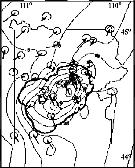
Forward models made with a 3-D boundary element technique can explain the caldera deformation with a shallow NE-elongate shaped, sill-like body beneath the caldera at depths of 3 km to 6 km (Figure 16) which lost volume at a rate of 0.02 km3/yr, similar to rates independently estimated for magmatic fluid release. This deflationary model was confirmed with a 3-D volumetric source model derived by simultaneous inversion of the horizontal and the vertical GPS displacement data. The inverse model indicates that the largest deflation is quite shallow, between the surface and 3 km depth, in the depth range of extensive hydrothermal fluids and possible magmatic fluids in Yellowstone.
It is evident from the regional GPS observations that the extent of the current Yellowstone GPS network is insufficient to measure crustal deformation associated with the long-wavelength signature of the Yellowstone hotspot. For example, topographic and geoid data suggest that the influence of the hotspot extends up to 500 km from the caldera. To examine these large-scale effects of the hotspot signature, the new Yellowstone GPS surveys are designed to reobserve much of the existing network and to make ties to the high-accuracy GPS networks of surrounding states which have approximately 100 km spacing.
Volcanic Processes
Geologic and historical records show that over 500 of the world's volcanoes can be considered to be "active" or capable of producing an eruption. The vast majority of these volcanoes are associated with subduction-zone plate boundaries. Although constituting only about 15% of the annual global magma production, subduction-zone volcanoes can be explosive and have dramatic effects on human populations. In contrast, most magma is generated at plate spreading centers at remote mid-ocean ridges. The remainder of volcanic activity is located along mantle hotspot tracks. Kilauea
Geodetic and seismic data have been used to model the geometry and depth of rift zone intrusions. Kilauea is a case in point. On Kilauea, these models indicate that the dikes are steeply dipping bladelike structures a few meters thick, typically at depths of between 2 and 4 km. Less is known about the deeper part of the rift system and the long-term deformation accompanying intrusion within plate-boundary rift zones. The Yellowstone Caldera
A GPS survey in 1987 established a dense network of 60 stations planned to measure crustal deformation of the active Yellowstone caldera and adjacent Hebgen Lake and Teton normal fault zones. Comparisons of data from a 1993 survey with GPS surveys in 1989 and 1991 show significant crustal deformation which is characterized by subsidence and contraction over the 60 km-long Yellowstone caldera superimposed upon a regional tectonic strain field. The principle components of the regional strain rate tensor, estimated using a method of simultaneous reduction after excluding data for stations outside the caldera, are  of northwest contraction and
  of northeast extension. After removing the regional strain components from the observed GPS field, the residuals of the inner-caldera sites revealed up to
  of horizontal displacement, directed radially toward the center of the caldera, and up to
  of caldera-wide subsidence. This corresponds to an average subsidence rate of 17 mm/yr.