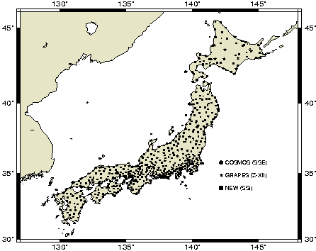
GSI's 610-station network will combine the 100-station nationwide "GRAPES" network, the 110-station "COSMOS" network which is centered around Tokyo, plus 400 new sites distributed over the entire country. Average spacing between sites will be ~ 30 km for all of Japan.
Data from the sites are transmitted daily to the central processing facility in Tsukuba. Sites are accessed via ISDN and public telephone lines. The new 610-station network will collect and download at 30 seconds for 24 hours/day resulting in ~ 1 GigaByte/day of data in the uncompressed standard Receiver Independent Exchange (RINEX) format. High-rate 1-second data are buffered at 120 stations and will be analyzed kinematically in case of an earthquake.
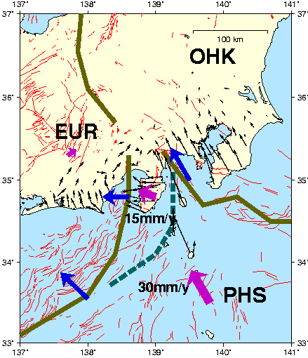
The primary purpose of the network is the determination of crustal strain in Japan. We show estimated station velocities after one year of analysis of data from the COSMOS network. Interesting results from the GRAPES network can be found on the GSI homepage at http://www.gsi-mc.go.jp/gsihome-e.html.
Three high accuracy software packages are currently in use at GSI: (1) Bernese/BPE, developed at the University of Bern, Switzerland, (2) GAMIT/GLOBK developed at MIT and SIO, and (3) GIPSY, developed at JPL. GSI plans to use all three packages for the analysis of data from the new 610-station GPS network. UCAR scientists are installing the BPE and coordinating the operation of the three software packages in collaboration with teams from GSI, Hitachi Zosen Information System Co., LTD., the University of Bern, MIT, SIO and JPL.
All three software packages will be operated from the same user interface, and three solutions will be computed for the entire network. These three solutions shall be compared and combined to form a "best" solution. GSI selected this approach to benefit from the different strengths and new developments in each of the three software packages, and to ensure that scientific competition and collaboration of the software groups will help to improve GSI products in the future.