RUSSIAN ACADEMY
OF SCIENCES
NATIONAL GEOPHYSICAL
COMMITTEE
NATIONAL REPORT
to the International
Association of Seismology
and Physics of the Earth’s
Interior
of the International Union
of Geodesy and Geophysics
1999 – 2002
![]()
Presented to the XXIII
General Assembly
of the International Union
of Geodesy and Geophysics
Editorial Board
M.V.Nevskiy (Chief Editor), A.D.Zavyalov (Deputy Chief
Editor), A.O.Gliko, A.F.Grachev, I.V.Kuznetsov, V.I.Ulomov, E.A.Khrometskaya
(Scientific Secretary).
Москва 2003
Ó National Geophysical Committee, RAS 2003
Contents
INTRODUCTION (M.V.NEVSKY)
1. SYSTEM OF SEISMIC OBSERVATIONS IN RUSSIA
1.1. THE
SEISMIC NETWORK OF THE GEOPHYSICAL SURVEY OF THE RUSSIAN ACADEMY OF SCIENCES (O.E.STAROVOIT, V.N.MISHATKIN)
1.2. THE
DEVELOPMENT OF SEISMOLOGICAL OBSERVATIONS METHODS (M.V.NEVSKY)
1.3. THE
DEVELOPMENT OF THE METHODS OF OBSERVATION DATA ANALYSIS (N.V.KONDORSKAYA)
2. STRONG AND
PERCEPTIBLE EARTHQUAKES ON THE TERRITORY OF RUSSIA DURING 1999-2002 (S.S.AREFIEV)
3. SEISMOLOGICAL STUDIES OF THE EARTH’S INTERIOR STRUCTURE (L.P.VINNIK, G.L.KOSAREV)
4. RESEARCHES OF SEISMIC HAZARD IN RUSSIA (V.I.ULOMOV)
5. THE PHYSICS OF SEISMIC PROCESS AND EARTHQUAKE PREDICTION (G.A.SOBOLEV, A.D.ZAVYALOV)
6. THEORETICAL
GEOPHYSICS AND GEOTHERMY (A.O.GLIKO)
7. MATHEMATICAL GEOPHYSICS
7.1.
SEISMIC SOURCE (B.G.BUKCHIN,
O.D.VOEVODA, I.V.KUZNETSOV)
7.2.
DYNAMICS OF SEISMICITY (I.V.KUZNETSOV,
P.SOBOLEV)
8. PHYSICAL PROPERTIES OF ROCKS UNDER HIGH PRESSURES AND TEMPERATURES (G.A.EFIMOVA, S.M.KIREENKOVA)
9. GEOINFORMATION
TECHNOLOGIES FOR ANALYSIS OF SEISMOTECTONIC PROCESSES (V.G.GITIS)
10. MONITORING OF INDUCED SEISMICITY IN MINES (A.A.MALOVICHKO, A.A.KOZYREV)
11. THE PARTICIPATION OF RUSSIAN SCIENTISTS IN INTERNATIONAL ORGANIZATIONS AND PROJECTS OF THE IASPEI IN 1999–2002 YEARS (N.V.KONDORSKAYA)
Introduction
М.V.Nevsky. National Geophysical
Committee, Russian Academy of Sciences; Schmidt United Institute of the Physics
of the Earth, Russian Academy of Sciences, Bol. Gruzinskaya str., 10, Moscow
123995 GSP, Russia.
This report submitted to the
International Association of Seismology and Physics of the Earth (IASPEI) of
the International Union of Geodesy and Geophysics (IUGG) contains a number of
major results that were obtained by Russian geophysicists in the period of 1999
– 2002. In the report prepared for the XXIII General Assembly, the results of
fundamental research are given briefly in seismology, geodynamics, theoretical
and mathematic geophysics, geothermy, in the research of rocks physical
properties under high pressures and temperatures and in some other fields as
well.
Period of 1999 – 2002 continued to
be difficult for Russian geophysics. Owing to the economic reforms in
In spite of such difficult conditions the high scientific potential, great experience of research work and traditions of Russian geophysics allowed obtaining a number of fundamentally new significant results. Many of them are given in the following sections of this report. Each of the sections is accompanied with a list of most interesting scientific publications issued in 1999 – 2003 including co-authored publications of Russian geophysicists and their foreign colleagues.
Among the results presented in the
report I would like to emphasize large generalizations in the construction of
block models of strong earthquakes centers on the basis of epicentral
observations in various seismically active regions of
In the last section of this report,
data are given about the work of Russian geophysicists in international
projects and their participation in the activity of international geophysical
organizations. It should be mentioned here that the National Geophysical
Committee RAS did a great deal of work to prepare the national report of
For a number of reasons not all of the results obtained by Russian scientists on seismology and physics of the Earth’s interior from 1999 to 2002 are given in this report. It is hoped that the authors will present their results at the sessions of XXIII General Assembly of IUGG.
1. System of seismic observations in Russia
1.1.
The seismic network of the Geophysical Survey of the Russian Academy
О.Е.Starovoit,
V.N.Mishatkin. Geophysical
Survey RAS, Lenin str., 189, Obninsk, Кaluga region, 249020,
Introduction
The seismic network of
The teleseismic network of the GS RAS operates around 30 seismic stations
and a data center in Obninsk. All stations have broadband recording channels.
Approximately half of them (14) have digital equipment; the others use
shortperiod and longperiod channels with records on photographic paper. The
equipment of 12 digital stations is made available by IRIS and is part of the Global Seismograph Network
(GSN). The characteristics of the 12 stations are similar to those of the other
GSN stations. The data of the digital stations are transmitted to the data
center in Obninsk by telephone in a mode close to real time. Further, the
datacenter of the teleseismic network regularly obtains data from other GSN
stations and has access to a number of databases outside
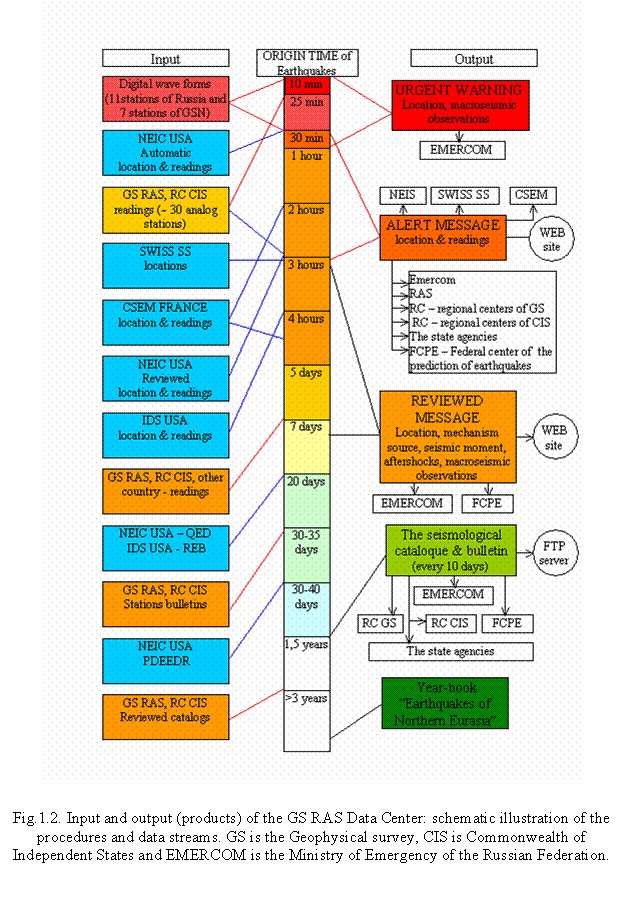
bulletin of seismic events. Fig.1.2 illustrates the different procedures and data streams within the network and throughput to the archive, other networks and users.
An important component of the teleseismic network is the
24-hour-a-day service to determine the location and magnitude of significant
earthquakes in
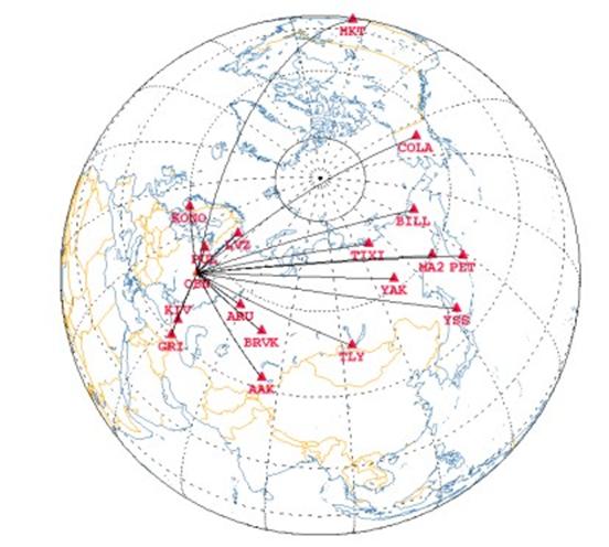
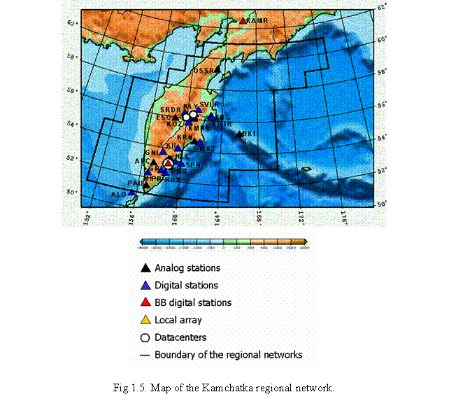
Fig.1.3. Map displaying all Broadband stations that contribute to the Alert Service of GS RAS. All stations except PUL are also part of the GSN.
This alert information is communicated to federal and regional
government agencies which are responsible for emergency response and to
scientific groups. Within less than 30 minutes after an earthquake the
"URGENT WARNING" message is send to the Emercom of the
Altay-Sayan region. The Altay-Sayan regional network (networkcode ASRS) monitors the
region 46°-56° N and 80°-100° E. The ASRS network consists of 20 stations and
two local networks with in total 38 digital stations that operate in the
frequency range 0,5-15 Hz and with a 16-24 bit dynamic resolution. The
datacenter of the network is situated in
Baykal region. In the region between 48°-60° N and 96°-122° E the seismic monitoring is carried out by the Baykal regional network (networkcode BYKL) (Fig.1.4).
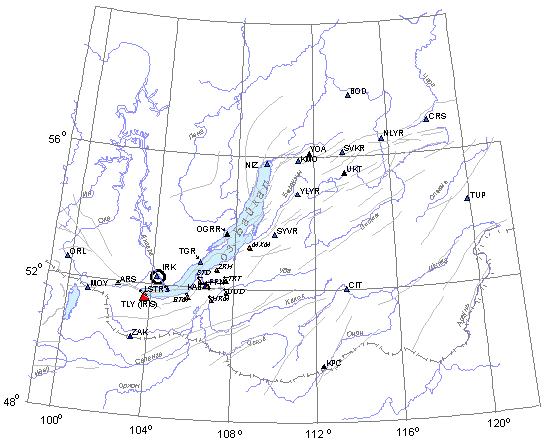
Fig.1.4. The regional network of the Baykal area.
For the legend see Fig.1.5
The BYKL network incorporates 24 stations, 13 of which have digital
recording equipment, that operates within the frequency range of 0,5-10 Hz and
a dynamic resolution of 15-17 bit. The network records annually more than 4000
earthquakes of all sizes. The datacenter of this network is situated in
The KRSC network consists of three local networks and some
individual stations. All together 2 digital broadband stations (PET and KAMR),
7 stations with analog recording and 27 shortperiod stations (0,7-20 Hz, 11 bit
resolution) with digital recording through a telemetry network. Each local
datacenter gathers its own data, manages its own stations and calibrates
regularly the seismic instrumentation. The local datacenters are all connected
to the regional center in
· Digital records of earthquakes and results of provisional processing (bulletins and catalogues) are stored in a database which can easily be accessed through the local computer network (by local users only);
· Bulletins and catalogues are available on a website to the seismological community;
·
Rapid warnings on strong
earthquakes in
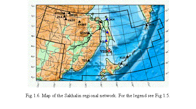
The SKHL network has 1
broadband digital station (YSS) and 4 digital stations (frequency range
0.02-10Hz and 16 bit dynamic range) on the
Northeast region. In the region of the Magadan area, Chukotka,
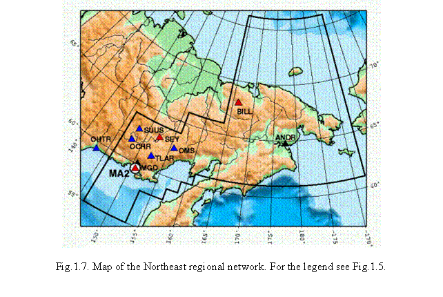
The NERS network consists of 11 stations out of which 3 broadband (BILL, MA2 and SEY) and 5 shortperiod stations with digital recording. The datacenter is in Magadan. The data are processed resulting in an event summary and every month a catalogue is issued.
Yakut region. Seismic monitoring of the region of the republic Sakha is provided by the Yakut regional network (networkcode YARS) (Fig.1.8).
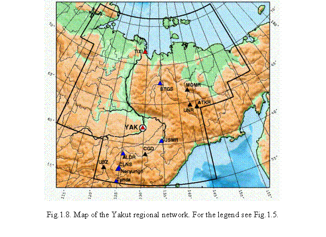
The YARS network consists of 13 stations. 2 broadband (TIXI and YAK)
and 5 short-period stations covering the frequency range 0,02-7 Hz and a
dynamic resolution of 16 bit have digital recording. The datacenter is situated
in
GS RAS cooperates with international and national seismological centers especially for data exchange and integration in the global system of seismic monitoring. The Geophysical Survey of the RAS provides, with its scientific experts in the field of seismic monitoring and instrumentation, the rapid warning services for the central and local authorities and other departments with respect to earthquakes and its possible consequences. The GS RAS collects and archives the data in an extensive seismic database that is available for scientists and researchers:
· On our website
- Events information, used by the Alert Service
- Catalogues and bulletins of teleseismic and regional networks
· Waveform data by AutoDRM. Send an email to autodrm@fsuhub.gsras.ru
· Catalogues and bulletins of teleseismic and regional networks are available by FTP on ftp://ftp.gsras.ru/pub/Teleseismic_Catalog/ and ftp://ftp.gsras.ru/Regional_Catalogs/
· Additional waveform data from the archive (~ 6 Tbyte) can be requested by email ceme@gsras.ru
References
Balesta S.T., Kopylova G.N., Latypov E.R., Kuz'min
Yu.D. Complex geophysical observations on
Kim Chun Un, Sen Pak Se. Results of seismic researches in a neighbourhood of Yuzhno-Sakhalinsk with use of digital seismic station DATAMARK // In: The earthquake sources of Far East, geodynamics of tectonospheare of a zone of a concatenation of Pacific ocean with Eurasia. т.V, 1997. (In Russian).
Starovoit O.,
Starovoit O., Mishatkin V. Seismic stations of
Starovoit O., Mishatkin V. The seismic network of
the
Starovoit O., Yunga S., Gabsatatova I., Chepkunas L. Destructive earthquake in Afghanistan (Hindu Kush) on March 25, 2002: - ORFEUS Electronic Newsletter Vol 4, No 2: September 2002,
Starovoit O., Yunga S.L. Seismological Observations and Geodynamic Zoning Predictions. // Encyclopedia of Life Support Systems. UNESCO, EOLSS. Ed.K.Rosner (In press).
1.2. The development of seismological observations
methods
М.V.Nevsky. Schmidt United Institute of the Physics of
the Earth, Russian Academy of Sciences, Bol. Gruzinskaya str., 10, Moscow
123995 GSP, Russia.
Recently the problem of seismological monitoring of megapolis and
large industrial objects areas has been growing more and more acute. Even
comparatively weak seismic events of natural origin or technogenous with
magnitudes of M=2–3 in megapolis and industrial centers may have dangerous
consequences especially with their systematic recurrence. At the same time the
problem of seismic events control in megapolis is strongly complicated by the
influence of seismic technogenous noise. From data by E.I. Galperin and his
colleagues who studied seismological regime of large industrial centers like
cities Tashkent and Alma Aty [Galperin et al., 1978] in the former Soviet Union,
mean square amplitudes of short-period seismic noise on the earth surface and
near it in the conditions of cities and industrial centers range from 200 to
800 nm. It is evident that even registration of local seismic events with
magnitudes M=2–3 is impossible in this case.
Common means of seismic noise suppression of the type of frequency filtration in this case prove ineffective in this case, since the frequency ranges of seismic events, natural microseisms and technogenic noises overlap to a considerable degree. Grouping seismic receivers set up near the surface is inefficient either, because grouping allows us to obtain only a several-time increase of signal-noise ratio by energy, whereas in our case we need the signal-noise ratio increase of tens of times.
At the same time there is strong evidence that seismological observations in deep wells (~1 km) are promising in the studies of seismic regime in large industrial centers. From data by Galperin and his colleagues [Galperin et al., 1978], the average amplitudes of seismic noises in frequency range of 0.6–0.8 Hz at depths h ³ 1.0 km show a decrease ranging from 10 to 30 times as compared with the surface. Similar data were given in previous papers on borehole seismology [Douze, 1964; Gupta, 1965].
The problem of seismic monitoring is topical in
Measurements of short-period microseism characteristics were made in the well with a step of 50–100 m in depth in frequency range from 0.5 to 30.0 Hz. To conduct the observations well velocimeter KMB–CIB was applied, which was designed by I.V. Ulomov and V.G. Mezhberg in UIPE RAS. Simultaneously with well observations, the measurements of noise characteristics were made on the surface with the use of short-period seismometer SM3-KV. In the well and on the surface, the registration of microseismic oscillations was carried out on z component of shift velocities. The daily variation of short-period microseism characteristics was measured at a depth of 850 m and in the surface. Detailed information on the instrumentation and method of the experiment is given in [Nevsky et al., 2002].
It was established from observation data analysis that the level of
short-period microseismic noise at a depth of 850 m shows approximately a 40
times decrease in mean square amplitudes of shifts velocities. At the same time
the results of the analysis of thickness spectra by shifts show that the abrupt
decrease of microseismic noise level occurs for a major part at the expense of
comparatively high-frequency components of the spectrum with frequencies of 3–4
Hz and higher. With frequency 1.0 Hz the spectral density 5 times decreases at
a depth of 850 m, whereas with frequencies of 3–10 Hz this decrease amounts to
2–3 orders. As the analysis of daily variation of microseisms characteristics
shows the abrupt decrease of microseisms intensity with depth is caused by a
considerable effect of technogenic noises, which are typical of so big a city
as
On the whole, the result of work demonstrates that seismological
observations in deep wells are very promising in creating the seismological
monitoring system of
References
Galperin E.I., Nersesov I.L., Vorovsky L.M. et al. Studies of seismic regime of large industrial centers. M. Nauka. 1978. Pp.187.
Douze E.J. Rayleigh waves in short-period seismic noise // BSSA. 1964. Vol. 54, # 4. Pp.1197–1212.
Gupta I.N. Standing-wave phenomena in short-period seismic noise // Geophysics. 1965. Vol. XXX, # 6, Pp. 1179 – 1186.
Nevsky M.V. The development of physical foundations of seismic methods of research of the Earth’s crust in UIPE RAS // Vestnik OGGGGN RAN, 2000. Vol. 1. Pp.148 – 154.
Nevsky M.V., Chulkov A.B., Ulomov I.V. et al.
Research in short-period microseismic noises in deep well in
Nevsky M.V., Chulkov A.B., Morozova L.A., Eremenko
O.A. Problems and prospects of seismological observations systems in the XXI
century // Problems of the geophysics of the XXI century. M. Nauka. 2003. Vol.
2. Pp.180–212.
1.3. The development of the methods of observation
data analysis
N.V.Kondorskaya. Schmidt United Institute of the Physics of
the Earth, Russian Academy of Sciences, Bol. Gruzinskaya str., 10, Moscow
123995 GSP, Russia.
A new approach to the parameterization of the processes in the earthquake source on the basis of approximation of the P-wave sources in the teleseismic zone with the help of multysectional kinematic model is being developed in IPE. Selection of separate phases of P-wave in the earthquake source on the basis of segmentation of seismograms and approximation of each phase of the sources P wave are provided. The frequency characteristics of the path are concidered independently on the basis of weak events.
References
Chirkov Ye.B., Kondorskaya N.V., Lagova N.A. The methodology of prametrization of the kinematic processes in the earthquake source // Doklady RAS. 2002, v.382, # 2, pp.256-260.
2.
Strong and perceptible earthquakes on the territory of Russia
S.S.Arefiev. Schmidt United Institute of Physics of the
Earth, Russian Academy of Sciences, Bol. Gruzinskaya str., 10, Moscow 123995
GSP, Russia.
During the period of 1992–2002 there were no large seismic
catastrophes on the
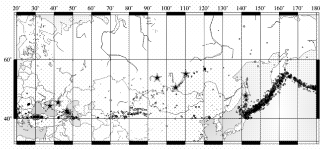
Fig. 2.1 The map of earthquakes of Russia and the vicinities
The strongest earthquake of
1992–2002 occurred on the
On
Vicinities of the
Two strong earthquakes with magnitudes Ms=6.1 (Mw=5.9)
and Ms=6.0 (Mw=5.9), respectively occurred on March 21, 1999 in the
northeastern part of the Baikal Lake with an interval of one minute at 16 h 16
min and 16 h 17 min. These earthquakes were felt in the following towns:
Nizhne-Angarsk, Kichera, and Verhnia Zaimka – intensity of 6; Severo-Baikals –
5–6;
Rather strong earthquake occurred on
Daghestan is undoubtedly the most seismically active
territory on the European part of
Besides, the increase in seismic activity was noted in
the central mountain part of Daghestan that was firstly observed in the period
considered on January 26, 1999 (Mb=4.1 according NEIC) and repeated in 2000.
The macroseismic effect within this series was rather high for the earthquake
of September 24 (Mb=4.6 according NEIC) that was felt in Levashi and Untsukul
with intensity of 4-5. And finally, the most destructive earthquake occurred in
this region on December 2, 2000 (Ms=4.6). According to data of the Daghestan
Geophysical service, the intensity felt was the highest in Mugi, Chuni, and
Akusha – 5-6. According to EMERCOM data, there were no human victims, however,
the damage of houses and constructions was significant. The swarm of
earthquakes described was less intense, as compared to the northern one located
in the zone of the earthquake of 1970. Aftershocks of each of relatively strong
events were not numerous and continuous.
It should be noted that the interest caused by an earthquake is not obligatory propotional to its magnitude. During recent years, the Salsk earthquake of May 22, 2001 (Ms=4.8) and the Nizhnekubansk earthquake of November 9, 2002 (Ms=4.5, Mb=5.0) should be regarded as rather important events in seismic state of the European part of Russia. The first one – due to its unexpectedness: no earthquakes of the comparable energy were recorded so far to the north from the seismically active Caucasus. The second one – due to it occurred in the densely populated region of the country and was studied in detail using macroseismic methods. This analysis enabled to define more precisely the results of the earlier strong earthquake of 1966.
The preparation of this section involves the data of GS RAS and NEIC; the moment magnitude was determined with the Harvard CMT solutions.
3. Seismological studies of the Earth’s interior structure
L.P.Vinnik, G.L.Kosarev. Schmidt United Institute of the Physics of the Earth, Russian Academy of Sciences, Bol. Gruzinskaya str., 10, Moscow 123995 GSP, Russia.
A variety of new results were obtained in the studies of the structure of the continental lithosphere and the upper mantle, phase transitions zone, lower mantle and the transition zone from mantle to the core. Tomographic models of the lithosphere were constructed on several long profiles. Contrary to widespread concepts, the tomographic model of the Baikal rift zone testifies to a high thickness of the subcrustal lithosphere. The structure of the mantle transition zone of the Asia eastern margin and hot spots in the Pacific was studied with the use of the receiver function. It has been demonstrated that in the hot spots area at a depth of 700 km lenses of matter may occur with anomalously low velocity of waves propagation. In Tibet area, a record thickness of the earth crust of approximately 70 km was established but no anomalies were revealed at depths greater than 300 km. What it means is that processes causing the rise of Tibet go on at lesser depths. Methods of seismic anisotropy were improved and research of azimuth anisotropy was carried out of the upper mantle of several continental areas. Most significant results were obtained in the studies of the upper mantle of Siberian platform. It is shown that the mantle at depths less than 150 km adds to the total anisotropy no more than 30%. The major effect is accumulated at depths below 150 km where it is associated with modern mantle flows.
Lateral variations of non-elastic absorption in the inner core were studied from seismic phases spectra propagated in the central area of the Earth. Areas were revealed of anomalous weak absorption beneath North America and anomalous strong absorption beneath the Pacific.
A correlation was established between absorption lateral variation and elastic anisotropy variation. In this case strong anisotropy corresponds to weak absorption.
3.1.
Introduction
In recent years, seismology progress has been associated with the development of global and regional networks of wide-band digital seismic stations. New seismic data offer possibilities for solving many problems of the structure and dynamics of earth interior. Major task is the research of the structure (heterogeneities and anisotropy) of earth interior with the use of new digital seismic records and modern methods of their analysis. This research was completed with the studies in theoretical seismology.
3.2.
Tomographic research of the lithosphere
Tomographic models of the lithosphere down to a depth from 250 to 300 km along a series of long profiles were constructed from remote earthquake records. Travel time of longitudinal waves served as initial data. Records were processed that had been obtained on the profile in Baikal rift zone and on the profile crossing Ural folded area. Observations on those profiles were carried out in the frame of international projects. Besides, data were processed that were obtained by Center GEON as a result of field observations of the two last decades. Those are profiles RUBIN, QUARTS, and TOLSTIK – KHIBINY crossing Baltic shield in different directions and profile MANASH – KARACHAGANAK running across Caspian Sea syneclise and eastern Russian plate. Most significant results were obtained on Baikal profile. Major features of the obtained velocity model are as follows: (1) longitudinal waves velocity increased by 1 % in the upper mantle of Siberian platform; (2) velocity decreased by 2% in the upper mantle of Baikal rift zone at depth more than 150 km; (3) velocity decreased by 1 – 2% in the upper mantle in northern Mongolia at depth less than 150 km. Contrary to the results of previous papers, combined analysis of these data and other seismic data shows that Baikal rift zone overlies subcrustal lithosphere with a thickness of no less than several tens of kilometers. New seismic data may be considered fit to the hypothesis of active rift formation if we assume that the asthenospheric diapir in Baikal rift zone stretches not only the crust but subcrustal lithosphere of a thickness of several tens of kilometers as well.
3.3.
The relief and the structure of seismic boundaries
Velocity models for the individual areas of the continental lithosphere and the upper mantle and the transition zone of the mantle were obtained. The relief and close structure of seismic boundaries in the phase transitions zone was studied for a major part with the use of receiver function method. Pressure (depth) of phase transitions is related to temperature, and thus, measuring temperature, we can judge about the lateral variations of temperature. Boundary features were analyzed in the areas of ascending and descending convective flows characterized with decreased and increased temperatures respectively. Far Eastern margin of Russia was taken as an area of descending flow. Ascending flow features were studied by the example of hot spots in the Pacific.
Contrary to foreign publications, no considerable subsidence of seismic boundary of 660 km was found in the Far Eastern zone. Neither a partial melting zone at a depth of 400 km, of which foreign publications informed was revealed. Transversal waves velocity jump at a depth of 660 km occurs in the depth range of no more than 10 km. In the studies of mantle boundaries in lithospheric plates subsiding in the Far Eastern subduction zone, the measurement was made of hodographs derivative of P waves registered by Baikal seismic stations network from sources located in Kuril and Japan subduction zones. Published data of seismic tomography suggest that the subsiding oceanic lithospheric plate does not penetrate into the lower mantle but lies on its top. Our data reveal transversal waves velocity anomaly of approximately 3 %, which is attributable to either a horizontal lithospheric plate or a known seismic boundary at a depth of approximately 530 km.
It is revealed that in the area of ascending flow the velocity jump at a depth of approximately 660 km occurs in an anomalously wide depth range of the order of several tens of kilometers. This anomaly can be explained by the fact that endothermic phase transition at a depth of 660 km makes a barrier for the hot flow ascending from the lower mantle. Low-velocity matter of the flow accumulates beneath phase boundary and forms a lens of a thickness of several tens of kilometers. In some places the lens matter penetrates through the phase boundary and forms hot spots of the earth surface. Seismic observations allow us to assume that in some places the matter of low-velocity lens does not penetrate through the phase boundary and hot spots are absent from the earth surface or are concealed by some other effects.
The relief of major boundaries in the transition zone was studied on global scale from records of about 100 seismic stations in various areas of continents. Deviations of boundaries depths from normal value commonly are no more than several kilometers. To them correspond lateral variations of temperature in the range of several tens of degrees. From seismic tomography data, a correlation, which is not great but is statistically significant, is noted between temperature variations established in this way and velocities heterogeneities in the transition zone. In the studies of deep structure of Tibet with the receiver function method, hundreds of remote earthquakes records were processed, which had been made by 10 stations forming a sublatitudinal profile in eastern Tibet. Data were processed with the application of some elements of migration method. A uniquely great thickness of the crust beneath Tibet stations (up to 70 km) was established which decreases northwards. At the same time boundary depths in the transition zone of the mantle show values typical of continents, thus testifying to small temperature anomalies in the transition zone of the mantle. Apparently, processes resulting in the rise of Tibet developed for a major part in the lithosphere, scarcely occupying depths greater than 300 km.
One more research carried out with the use of the receiving function method is devoted to the problem of absorption in the mantle. The range of frequency band in which seismic waves are absorbed was investigated. A combination was used of the travel time of longitudinal waves at stations in North America, anomalies of travel time of transversal waves established with the use of receiver function and experimental data of high pressure physics on the relation between wave velocities and temperature in ultrasound frequency range. The results of this research show that high frequency section of absorption band in the west of North America is located in the frequency range of the order of 100 Hz far out of the seismic range limits. Melting apparently causes the high frequency of the section and henceforward the partial melting can be diagnosed in the upper mantle with the use of the proposed method.
3.4.
Upper mantle anisotropy
Work was carried out of mapping seismic anisotropy or continental upper mantle. Seismic anisotropy is determined by the ordered orientation of crystals (primarily, olivine), which is caused by mantle plastic flow. The parameters of anisotropy may and should vary with depth: in the subcrustal lithosphere at low temperature, crystals orientation reflects deformation processes of the geological past, whereas, in the asthenosphere, recent or modern processes govern anisotropy. The major method of measuring continental mantle anisotropy is based on the observation of transverse wave splitting into two waves in SKS seismic phase. This phase propagates in subvertical direction and the method has a high horizontal resolution with an insignificant vertical resolution. The major goal of research work on earth mantle anisotropy is to elaborate methods for substantiated interpretation of seismic data on the dependence of anisotropy from depth and three-dimensional mapping of anisotropy in the upper mantle of Eurasia.
Significant results were obtained in the elaboration of methods of seismic research of anisotropy. The receiver function method for P waves developed before was considerably improved. In this method, the longitudinal wave and secondary waves related to it are transformed in such a way that their waveforms become alike in earthquake records with different function in the source. After that harmonic analysis of two components of shift (SV and T) is carried out in azimuth area. The effects of anisotropy dependant on depth are present in the second azimuthal harmonic of the both components. We improved harmonic analysis method and now it shows good results with a considerably uneven distribution of seismic events used. In harmonic analysis of two components we use different weight coefficients. As a result, the parameters of the second azimuth harmonic are alike if they reflect azimuthal anisotropy effects. This similarity may be used as a criterion for distinguishing effects of azimuthal anisotropy and lateral heterogeneity.
When using this method some difficulties arise in distinguishing converted mantle waves Ps from crustal waves repeatedly reflected. To overcome this difficulty converted waves Sp may be used. In this case repeatedly reflected crustal waves arrive with a certain delay with respect to mantle exchange waves. To separate Sp waves and their azimuthal variations caused by anisotropy we elaborated a special technique of record processing, which can be called receiver function method for S waves. Both methods were applied to records of Grefenberg group in Germany and the obtained results were close. The analysis of receiver functions for P waves showed that the upper layer of the mantle of a thickness ranging from 50 to 60 km is anisotropic with the azimuth of fast direction of approximately 20 degrees. Fast direction under this layer has the azimuth of 110 degrees.
Similar fast direction of anisotropy (110–120 degrees) was established by the analysis of SKS phase splitting at a number of stations in eastern Europe (Uzhgorod, L’vov, Kiev, Simferopol, Yalta and others). In Carpathians area, the same fast direction was revealed in Pannonian basin where subcoral lithosphere is practically missing and in the margin of the Russian platform having a thick subcoral lithosphere. What this similarity means is that the observed anisotropy was not inherited from previous tectonic processes and is not located in the lithosphere. The same fast direction was found in Central Europe where Grefenberg Group is situated and in Eastern Europe, thus suggesting that this direction is associated with a large-scale flow in the upper mantle. Interestingly, this direction is perpendicular to Yaily, though in young mountains, fast direction of anisotropy commonly coincides with ridges strike.
Transversal waves receiver function method modification was successfully used to determine the structure of the crust and the upper mantle of the Moon. It was established that the structure of the Moon crust can considerably differ from the one obtained in previous research. A notable dispersion of transversal waves was revealed in the Moon’s mantle.
Significant results were obtained in the studies of the anisotropy of Siberian platform. Earlier there were no seismic data on this vast territory. We carried out our research work owing to setting up three temporary seismic stations in Yakutia, in areas of diamond deposits. We set up the stations in cooperation with geophysical institutes of Germany and joint stock company “Diamonds of Russia – Sakha”. Measurements of splitting in SKS phase by temporary stations were completed with similar measurements at permanent stations in the margins of Siberian platform and Baikal seismic experiment data. The results of the measurements show that practically the same fast direction of anisotropy with azimuth of approximately 150 degrees was observed on the whole territory under investigation. The delay of slow split wave arrival with respect to fast wave commonly makes approximately 1 s.
To help determine the nature of this anisotropy a unique network of long profiles is used on which longitudinal waves from peaceful nuclear explosions were traced up to 2000 km and more. Depending on the epicentral distance, these waves lighten the upper mantle from Moho boundary to transition zone. Two profiles (RIFT and METEORIT) run parallel to fast direction of anisotropy and two other profiles (KRATON and KIMBERLIT) have orientation intermediate between fast and slow direction. A comparison of data on splitting of transversal waves propagating subvertically and on the travel time of longitudinal waves propagating subhorizontally along long profiles is of interest for two reasons. First, observations of anisotropy in P waves can help estimate the distribution of anisotropy and corresponding deformations with depth. Second, it is necessary to recognize the role of anisotropy in observation data on long profiles in order to avoid errors in these data interpretation in terms of lateral and radial heterogeneity of the Earth.
Research in upper mantle xenolith with the use of petrophysical data was conducted by joint efforts. As a result, it was established that mantle contribution into the observed splitting at depths less than 150 km is no more than 30 % of the total effect in SKS phase. Major effect is accumulated in the thick low-velocity layer the top of which is revealed at a depth of approximately 150 km. Anisotropy in this layer is associated with recent mantle flow (lithospheric plate drift).
The research of mantle anisotropy in Sayany-Altai region was conducted with the use of SKS method by observations of 8 permanent analog stations. Most pronounced result of this work is the close relation established between deformations in the crust and in the upper mantle. In this case, fast direction of anisotropy in the upper mantle is strictly perpendicular to the compression direction in the crust determined from mechanisms of local earthquakes centers, thus suggesting a close relation between deformations in the upper mantle and in the crust.
3.5.
The structure of the lower mantle and the transition zone from the mantle to
the core
Significant results were obtained in the studies of the features of D'' zone in the mantle base. Methods of records analysis of transversal waves diffracted at the core boundary were elaborated, which allow taking into account the effect of upper mantle anisotropy. Strong lateral variations of transversal waves velocities in the layer abutting the core surface were revealed beneath the central area of the Pacific. In this case, the lateral variations of velocity are accompanied by a remarkably strong anisotropy of velocities that manifests itself in the difference of the velocities of diffracted waves SV and SH and testifies to intensive deformations in this layer. Search for mantle effects was carried out in the mantle’s base. Recently the melting hypothesis received many supporters. We showed that melting is missing or occurs in the layer of a thickness less than 0–15 km which is beyond the resolving capacity of our method.
Methods were elaborated for seismic signals identification and signals excited on the lower mantle boundary were searched for. Although indications of seismic boundaries in the lower mantle have been known for a long time, their global character and even the fact of their existence is debatable. We analyzed all digital seismograms data on deep earthquakes that had occurred before the end of 1999. Clear results were obtained from the analysis of (1) deep earthquakes of Arch. Zondes recorded by stations in East Asia; (2) deep earthquakes in the area of islands Kermadec, Fiji, Tonga, recorded by stations network in Japan and East Asia and (3) deep earthquakes in northwest of the Pacific (Marianas islands, Bonin I., Japan islands) recorded by stations in North America. Strong evidence was obtained in favor for boundaries occurring at depths of 860–880 km, 1010–1120 km, 1170–1250 km and 1670–1800 km. Most distinct signals were received from boundaries at a depth of approximately 1200 km. There are good grounds to believe that boundaries at depths of approximately 900 km, 1200 km and 1700 km are of global character. A relation between character of lower mantle lamination and subduction type is noted from seismic tomography data.
3.6.
Conclusion
As a result of the studies of the last few years, highly efficient methods of anisotropy mapping were elaborated, which allowed high horizontal and vertical resolution, and fundamentally new data were obtained on the parameters of mantle anisotropy and corresponding deformation processes in Eurasia. The location of the upper boundary frequency of absorption band in the asthenosphere was determined.
Seismic layering of the lower mantle of the Earth was studied. Signals were identified that were associated with boundaries at depths of approximately 900 km, 1100 km, 1200 km and 1700 km. Seismic layering of the lower mantle shows a relation to the subduction process.
References
Breger L., Romanowicz B., Vinnik L. Test of tomographic models of D'' using differential travel time data // Geophys. Res. Lett. 1998. Vol.25, # 1. P.5-8.
Chevrot S., Vinnik L., Montagner J.-P. Global scale analysis of the mantle Pds phases // J. Geophys. Res. 1999. Vol.104. P.20203-20219.
Dricker I., Vinnik L., Roecker S., Makeyeva L. Upper-mantle flow in Eastern Europe // Geophys. Res. Lett. 1999. Vol.26, # 9. P.1219-1222.
Farra V., Vinnik L. Upper mantle stratification by P and S receiver functions // Geophys. J. Int. 2000. Vol.141. P.699-712.
Farra V., Vinnik L. Upper mantle stratification by P and S receiver functions //Geophys. J. Int. 2000. Vol.141. P.699-712.
I.G.Dricker, S.W.Roecker, L.P.Vinnik, E.A.Rogozhin, L.I.Makeyeva. Upper mantle anisotropy beneath the Altai-Sayan region of central Asia // Phys.Earth and Planet.Int. V. 3. P.206-223. 2002.
Kosarev G.L., Kind R., Sobolev S.V., Yuan X., Hanka W., Oreshin S. Seismic evidence for detached Indian lithospheric mantle beneath Tibet // Science. 1999. Vol.283. P.1306-1309.
L.Vinnik, V.Farra. Subcratonic low-velocity layer and flood basalts // Geophys.Res.Lett. 2002. V.29. # 4. P.8-1 - 8-4.
Mordvinova V.V., Vinnik L.P., Kosarev G.L., Oreshin S.I., Treusov A.V. Teleseismic tomography of the Baikal rift lithosphere //Dokl. RAN. 1999. V.372. # 2. Pp.248–252.
Oreshin S., Vinnik L. Peregoudov D. Lithosphere and asthenosphere of the Tien Shan imaged by S receiver functions // Geophys.Res.Lett. V.29. # 8. P.32-1 -32-4. 2002.
Oreshin S., Vinnik L., Makeyeva L., Kosarev G., Kind R., Wentzel F. Combined analysis of SKS splitting and regional P traveltimes in Siberia // Geophys. J. Int. V.151. P.393-402. 2002.
Oreshin S., Vinnik L., Treussov A., Kind R. Subducted lithosphere or 530 km discontinuity? // Geophys. Res. Lett. 1998. Vol.25, # 7. P.1091-1094.
Stutzmann E., Vinnik L., Ferreira A., Singh S. Constraint on the S-wave velocity at the base of the mantle // Geophys. Res. Lett. 2000. Vol. 27, # 11. P.1571-1574.
Thirot J.L., Montagner J.-P., Vinnik L. Upper-mantle seismic discontinuities in a subduction zone (Japan) investigated from P to S converted waves // Phys. Earth and Planet. Inter. 1998. Vol.108. # 1. P.61-80.
Vinnik L. The mantle beneath the Kaapvaal craton // South African Geophys. Rev. 1998. Vol.2. P.51-54.
Vinnik L., Breger L., Romanowicz B. Anisotropic structures at the base of the Earth's mantle // Nature. 1998. Vol.393, # 6685. P.564-567.
Vinnik L., Breger L., Romanowicz B. On the inversion of Sd particle motion for seismic anistropy in D'' // Gеoph. Res. Lett. 1998. Vol.25, # 5. P.679-682.
Vinnik L., Chenet H., Gagnepain-Beyneix J., Lognonne Ph. First seismic receiver functions on the Moon // Geophys. Res. Lett. 2001. Vol. 28, # 15. P.3031-3034.
Vinnik L., Chevrot S., Montagner J.-P. Evidence for a stagnant plums in the
transition zone? // Geophys. Res. Lett. 1997. Vol.24, # 9. P.1007-1010.
Vinnik L., Chevrot S., Montagner J.-P. Seismic evidence of flow at the base of the upper mantle // Geophys. Res. Lett. 1998. Vol.25, # 11. P.1995-1998.
Vinnik L., Chevrot S., Montagner J.-P., Guyot F. Teleseismic travel time residuals in North America and anelasticity of the asthenosphere. // Phys. Earth and Planet.Inter. 1999. Vol.116. P.93-103.
Vinnik L., Kato M., Kawakatsu H. Search for seismic discontinuities in the lower mantle // Geophys. J. Int. 2001. Vol.147, # 1. P.41-56.
Vinnik L., Niu F.L., Kawakatsu H. Broadband converted phases from midmantle discontinuities // Earth, Planets and Space. 1998. Vol.50, # 11-12. P.987-997.
Vinnik L.P. Mantle and core of the Earth // Encyclopedia of the life supporting systems. 2001.
Vinnik L.P. Seismic properties of mantle plumes // Problems of global geodynamics: Theoretical seminar materials of OGGGN RAN. 1998–1999. / Ed. By Academician D.V.Rundkvist. M. GEOS. 2000. Pp.104–110.
Vinnik L.P. The structure and the dynamics of paleoplatforms mantle in the light of seismic data // Vestn. OGGGGN RAN. 1998. # 4(6). Pp.60–69.
Vinnik L.P., Kosarev G.L. Splitting transverse waves in phase transition zone // Doklady RAN. 1997. V.354. # 4. Pp.531–534.
Vinnik L.P., Kosarev G.L., Petersen N.V. Transmitting functions of the mantle in the Far Eastern subduction zone // Doklady RAN. 1997. V.353. # 3. Pp.379–382.
Vinnik L.P., Roecker S., Kosarev G.L., Oreshin S.I., Koulakov I.Yu. Crustal structure and dynamics of the Tien-Shan // Geophys. Res. Lett. V.29. # 22. P.4-1 - 4-4. 2002.
Zolotov E.E., Kostiuchenko S.L., Rakitov B.A. Treusov A.V. Tomographic sections of the East European platform lithosphere // Seismological model of Northern Europe lithosphere. Barents region. Eds. F.P.Mitrofanov and N.V.Sharov. Apatity. 1998. Part 1. Pp.71–79.
Zolotov E.E., Kostiuchenko S.L., Rakitov B.A., Treusov A.V. et al. Heterogeneities of the upper mantle of the Baltic shield from seismic tomography data // Subsurface exploration and protection. 2000. # 2. Pp.27–29.
Zolotov E.E., Kostiuchenko S.L., Rakitov B.A., Treusov A.V. Tomographic studies of Central Eurasia on regional profile “Bitum” // Subsurface exploration and protection. 2001. # 2. Pp.18–20.
Zolotov E.E., Kostiuchenko S.L., Rakitov B.A., Yasiulevich N.N., Kosarev G.L., Treusov A.V. Deep structure of the lithosphere of the East European platform from seismic observations // Subsurface exploration and protection. 1998. # 2. Pp.11–18.
Zorin Yu.A., Mordvinova V.V., Turutanov E.Kh., Belichenko B.G., Artemyev A.A., Kosarev G.L., Gao S.S. Low seismic velocity layers in the Earth's crust beneath Eastern Siberia (Russia) and Central Mongolia: receiver function data and their possible geological implication // Tectonophysics. V.359. P.307-327. 2002.
4.
Researches of seismic hazard in Russia
V.I.Ulomov. Schmidt United Institute of the Physics of the Earth, Russian Academy of Sciences, Bol. Gruzinskaya str., 10, Moscow 123995 GSP, Russia.
The seismicity of Russia and adjacent countries located on the territory of Northern Eurasia is due to their territories being part of the tectonically extremely complex Eurasian continent which is the arena of intensive geodynamic interaction between large lithosphere plates: the European, Asiatic, African, Arabian, Hindustan, Chinese, North-American and Pacific plates. In 1991–1997 the set of General Seismic Zoning (GSZ) probabilistic maps of Northern Eurasia – GSZ-97-A, GSZ-97-B, GSZ-97-C, and GSZ-97-D (Editor-in-Chief V.I.Ulomov) was prepared on the basis of new methodology and the unified seismological and geological-geophysical database. According to GSZ-97 the probability of a possible exceedance of earthquake intensity within 50 years shapes up as follows: 10 percent (map A), 5 % (B), 1 % (C), and 0,5 % (D) which corresponds to the mean periods of 500, 1,000, 5,000, and 10,000 years for the recurrence of such effect. The GSZ-97 cover the vast area, including the Russian Federation, all the CIS countries, and also Estonia, Latvia, Lithuania, Romania, areas of Caucasus, Central Asia, Northern Iran, Eastern Turkey, Afghanistan, Mongolia and North China. In 1999 the GSZ-97-A map is in terms of peak ground acceleration (PGA) it has been incorporated in 1999 into the World Map of Global Seismic Hazard Assessment.
In 2000 the set of GSZ-97 (A, B, and C) maps was adopted for the area of the Russian Federation (Fig.4.1) as the standardizing document and included into the new edition of the national Building Code “Construction in seismic regions”.
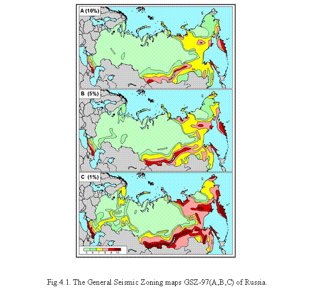
It has replaced a former GSZ map of 1978. The GSZ-97 maps allow to assess the extent of seismic hazard for objects of various service life periods and categories of responsibility. Thus, the GSZ-97-A map was recommended for the construction of residential, public and production buildings; the other two maps (B and C) - for the objects that should continue in service even during earthquakes and during work to eliminate their aftereffects (power and water supply, fire stations, communication facilities, transportation routes) and also for premises housing a large number of people (hospitals, schools, kindergardens, railway stations, air terminals, theaters, roofed-in markets, stadiums and like structures) and for buildings higher than 16 stores. The GSZ-97-D map was recommended for seismic hazard assessment of nuclear power plants or other critical or ecologically dangerous objects.
According to the GSZ-97 maps over a quarter of the area occupied by the Russian Federation is subject to seismic influences exceeding intensity of 7 on the MSK-64 scale and requiring antiseismic measures. Very dangerous zones of intensities of 8-9 and 9-10 occupy a considerable part of the territory of Russia. The whole Far East, including Kamchatka, Sakhalin and the Kuril islands, Altai, Sayany, the Baikal region, the Stanovoi mountain range, Yakutia and the North Caucasus, fall into these zones. The regions that presently exhibit low activity together with the shelf of marginal and enclosed seas also represent a certain seismic hazard. First of all, such is the European part of Russia including the Kola peninsula, Karelia, the Middle Urals, the land along the Volga, the Caspian sea depression and the Azov sea region.
In 1999–2000 the GSZ-97 set is supplemented with maps indicating the recurrence periods for jolts of different intensity; this is likewise important for the practice of antiseismic construction because multiple seismic shocks may cause mechanical damages which, if accumulated, can size ably reduce the strength of structures and, consequently, affect their resistance to subsequent quakes.
In 2002 the Government of the Russian Federation has approved the Federal Program “Seismic safety of the Russian territory” (2002-2010). The GSZ-97 maps are its basis. Up to this time neither in the former USSR, nor in Russia similar programs did not exist. The purpose of this Program is the maximal increase of seismic safety of the population, reduction of social, economic, ecological risk in seismically dangerous areas of the Russian Federation, decrease of damages from destructive earthquakes by certification, strengthening and reconstruction of existing buildings and constructions, and also preparation of cities and other settlements, transport, power constructions, pipelines for strong earthquakes. Specification of seismic hazard assessments for seismically active regions and development methods of the long-term prediction of strong earthquakes are one of the main tasks of seismological studying. The new methodology developed by GSZ-97 underlies such studying.
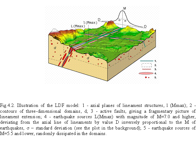
More detailed identification of earthquake sources is carried out on the basis Lineament-Domain-Focal (LDF) model of earthquake sources zones and the determination of seismicity parameters for them. This technique has been called EAST-97 – Earthquake Adequate Sources Technology. The LDF model (Fig.4.2) contains four scales: (1) a major region with an integral seismicity characteristic and its three main structural elements: (2) lineaments, which roughly represent the axes of the tops of 3-D earthquake-generating fault features and structured seismicity, and which form the backbone of the LDF model; (3) domains, which cover the area without gaps and are characterized by diffuse seismicity; (4) potential earthquake sources indicating the most dangerous segments and which are generally confined to lineaments.
The main new features and advantages of the technique and programs proposed and realised in GSZ-97, as compared to the former techniques, are the following:
· the capability is developed for incorporating various information on seismicity (structurization of the seismicity field, the nonlinearity of the recurrence graph, and so on) and on sources (dimension, orientation, the relieved stress, and so on), which was formerly ignored;
· the theoretically substantiated description of the field of incoherent radiation in the vicinity of an extended source is applied, which has allowed to solve the problem of overstating the intensity in the case of small distances and to automatically model the elliptically of isoseimals within the zone nearest to the sources of large magnitudes;
· the depth distribution of sources of finite dimensions is taking into account;
· the location of extended sources within the limits of a given zone is controlled, and the effects related to the location of extended sources of large magnitudes at linear structures, the lengths of which are comparable to the dimensions of these sources, are taken into account correctly;
· the resulting set of maps of seismic hazard in terms of intensity with a certain shake recurrence period allows us to make a probabilistic estimation of seismic hazard within the given territory and to provide the uniform of risk within the limits of the map with the recurrence period given.
Fixation of the huge file of initial and target data in a digital electronic form within the Geographical Information System (GIS ESRI) is a distinct fundamental achievement of the GSZ-97 technology as compared with all previous techniques. It permits obtaining rapidly reference analytical information on all the parameters and to use the seismological and geological-geophysical data for the preparation of different maps, as well as to the assessment of seismic hazard and seismic risk.
New methods are proposed for the monitoring of regional seismogeodynamic processes and the long-term prediction of strong earthquakes long-term prediction of strong earthquakes. Further research is required for more reliable localization of potential earthquake sources.
References
Balassanian S., Ashirov T., Chelidze T. et al. Seismic hazard assessment for the Caucasus test area // Annali Geofis. 1999, vol. 42, pp.1139-1151.
On the long-term prediction of strong earthquakes in Central Asia and Black Sea-Caspian region (Coauthors Polyakova T.P., Medvedeva N.S.) // Izvestiya, Physics of the Solid Earth, Vol. 38, # 4, 2002, pp.276-290.
Ulomov V.I. Regional seismicity and identification of the earthquake source occurrence zones for seismic zoning of Northern Eurasia // Journal of Earthquake Prediction Research. SSB-Beijing. China. UIPE-Moscow. Russia. 2000, vol. 8, № 1, pp.79-91.
Ulomov V.I. Seismic hazard assessment in Russia
// Abstracts of the IUGG General Assembly. 2003 (in
press).
Ulomov V.I. Seismic menace in Russia // Science in Russia. 2001. # 6.
Ulomov V.I. Seismogeodynamics and seismic mapping of North Eurasia // Volc. Seis. 2000, vol. 21. Singapore: OPA (Overseas Publisher Association), pp.407-432.
Ulomov V.I., and GSHAP Working Group. Seismic hazard of Northern Eurasia // Annali Geofis. 1999, vol. 42, pp.1023-1038.
Ulomov V.I., Shumilina L.S. Importance and basic aspects of the General Seismic Zoning of the territory of Russia. // Journal of Earthquake Prediction Research. SSB-Beijing. China. UIPE-Moscow. Russia. 2000, vol. 8, № 2, pp.130-144.
5.
The physics of seismic process and earthquake prediction
G.A.Sobolev, A.D.Zavyalov. Schmidt United Institute of the Physics of the Earth, Russian Academy of Sciences, Bol. Gruzinskaya str., 10, Moscow 123995 GSP, Russia.
From 1999 to 2002, Russian scientists obtained the following results on the physics of seismic process and earthquake prediction that are significant for the development of physical ideas of the process of geomaterials destruction of various scale.
Combined analysis of data of laboratory modeling and full-scale observations of earthquakes centers development was completed. As a result of detailed analysis of the parameters of acoustic emission and a series of laboratory experiments the regularities were revealed of macrorupture with controlled loading of rocks: 1) acoustic quiescence in the outer area with respect to the center; 2) activation of acoustic activity in the vicinity of the forming center; 3) acceleration of clustering of acoustic events in the zone of future rupture that are associated with fundamental stages of destruction preparation (accumulation of microfissures scattered in volume); 4) fusion and enlarging of fissures as they reach critical concentration; 5) pulling off fissures up to the surface of the future macrorupture. The stage of foreshock clustering was separated that reflects avalanche-like formation of fissures in the destruction center and indicates its passing into unstable state. The revealed features of acoustic activity and its stages may be used in the practice of prediction when tracking potential earthquakes centers from seismological data. Research in processes similarity was carried out in laboratory and full-scale. Regularities established in laboratory were used in the analysis of seismicity of Russia, Japan, Greece, Italy and China. As a result, the following fundamental parameters of seismic process and geophysical parameters associated with it were studied: 1) concentration criterion of ruptures of seismic origin; 2) dynamics of seismicity localization; 3) sequence of stages of quiescence and seismicity activation; 4) energy of foreshock activation; 5) determined chaos in the structure of geophysical series of observation data; 6) modulating seismicity with earth tides; 7) magnetic storms influence on seismicity. The analysis of the combination of seismological parameters and geophysical fields allowed us to improve prognostic algorithms.
Similarity criteria were studied with loading rock samples in laboratory experiments with feedback. It was shown that the use of acoustic activity considerably improved meeting similarity criteria and made the experiment more close to full-scale conditions. The obtained results show that the use of feedback in laboratory modeling of seismic process is promising.
Two series of experiments were carried out on exciting acoustic emission with electric signals. In the first series, models containing piezoelectric minerals (quartz) were used and in the second series we used quartz-free rocks. It was established that sending rectangular electric signals with a period of 1 MHz and 2.5kHz resulted in the increase of acoustic emission by 4-5% in quartz containing models and by 1 % in quartz-free models. No increase of acoustic emission was recorded under the effect of sinusoidal current of the same amplitude. The conducted experiments and the assessment of electromechanical transformation of energy suggest that the observed effect has a trigger mechanism.
The kinetic theory of aftershock process asymptotic was constructed. It was shown that Omori law is a consequence of this theory and the exponent of the power is determined by the function of earthquake distribution by energy on "the tail" of aftershock sequence.
From the assumption of fractal structure of the set of potential hypocenters of earthquakes, an equation was theoretically derived that describes the process of seismic energy release before a strong earthquake and its log-periodical generalization.
Considering aftershocks as a consequence of the main shock effect on the environment it is shown that the intensity of aftershock sequences caused by earthquake of intermediate force is on the average significantly greater when the epicenter of the main shock is located in a relatively small time-space area of strong earthquake preparation as compared to the cases when the main shock is out of this area. This result may be interpreted as a consequence of Earth crust instability to weak disturbances in the area of strong earthquake preparation.
As a result of seismicity variation research in seismically active areas of the Caucasus and Tien Shan in periods before and after magnetic storms with a sudden beginning, a conclusion was made of a likely influence of electromagnetic sources of natural origin on seismicity. It was established that the duration of response in seismicity to the magnetic storm effect is of an order of 10 days and in the process the maximum falls in the range from the second to the seventh day from the beginning of the storm. In individual areas of those regions the effect is pronounced, in other areas the effect is either very weak or it does not manifest itself at all, which may be explained by different geological and geophysical features of the areas. It is assumed that magnetic storms make an effect of a trigger on seismic activity. Among likely mechanisms of the discovered trigger effect of the electromagnetic field on seismicity, at least two phenomena studied by geophysics may be noted: reverse piezoelectric and seismic electric effects.
Using the analysis of earth tides influence of weak seismicity in time - space area of strong (M>7) earthquakes of Kamchatka as an example, it is shown that in the process of strong earthquakes preparation the phase of seismic quiescence identified from RTL parameter is preceded by a phase during which weak seismicity is modulated by variations of some horizontal components of tidal relative deformations. For four earthquakes having similar mechanisms of the centers and hypocenters depths, the azimuths Fi of modulating tidal components fall within the interval from 90 to 150 grad. For the earthquake of 1971 that was deeper (hypocenter depth is 100 km) the azimuth Fi of modulating component is 30 grad. It was also shown that in this case weak events tend to occur with greater negative meanings of the corresponding component of tidal relative deformations (compression).
Seismic process phases were studied before the disastrous earthquake in Kobe (Japan) with the use of RTL algorithm. It was revealed that 1.5 years before the earthquake a seismic quiescence phase had manifested itself that had been replaced with a foreshock activation phase 7 months before the earthquake. Major features of those phases are analogous to those mentioned above for Kamchatka earthquakes. It testifies to the similarity of the process of earthquake preparation in different seismic and tectonic settings.
The results were analyzed of MEE (Map of expected earthquake) algorithm tests of many years for medium-term strong earthquakes prediction with K³12.5 (M³5.5) in various seismically active regions of the world. The algorithm included a combination of various precursors. It was shown that the average prognostic efficiency of the algorithm was 2.5 times as much as with random guessing. In this case in the zones with assumed probability of strong earthquake occurrence of P(D1çK)³70%, on the average, 65% of predicted events occurred and the average area of the alarm zones made 30 % of the areas under study. It was established that most efficient prognostic indicator used in algorithm MEE was the parameter of seismogenic ruptures density Ksf, average prognostic efficiency of which in the tested areas made J=4.96±2.39. From the obtained results the conclusion was made that MEE algorithm may be recommended for use to strengthen observations of other precursors in the separated zones with a high assumed probability (more than 70%) and to take necessary preventive measures to mitigate likely economic and social losses of the coming earthquake.
The results of research on long-term earthquake prediction for Kuril-Kamchatka arc were analyzed with the use of the method based on the knowledge of regularities of strongest earthquake centers location and seismic cycle features. It was shown that predictions for periods of 1986-1990, 1991-1995 and 1996-2000 proved to be correct. In these years the most dangerous "seismic gaps" were separated and the places of occurrence of earthquakes with M³7.7 were predicted correctly (Shikotan earthquake of 4.10.1994, M=8.1 and Kronotskoe earthquake of 5.12.1997, M=7.8). Prediction for period 2001-2005 was given. A probability characteristic of earthquake occurrence with M³7.7 was introduced for each section of Kuril-Kamchatka seismogenic zone for the predicted period. Its average value for the whole zone makes from 3.6 to 4.2%. For different sections of the zone it varies in the range from 0.2 to 20.0% and depends on the stage of development of seismic process in them.
Combined analysis was made of geophysical measurements data of many years (seismic conditions parameters, ratio Vp/Vs, geomagnetic field intensity, underground water characteristics) obtained in Alma-Aty seismic prognostic site of the Institute of Seismology MON of Kazakhstan Republic. Specialists of IPPI and UIPE RAS carried out the analysis with the use of special program complexes developed. It was shown that the proposed approach allows us to separate components of geodynamic process related to the units of tectonic structure of the region and to estimate statistically significant numerical characteristics of the dynamics of geophysical parameters. Time-space variations of dynamic fields were revealed that are related to the preparation of local strong earthquakes.
Mathematical procedure was proposed and used in a program of correlating scaling of two statistically self-similar two-dimensional probability distributions, constructed with the use of multiplicative cascade scheme. The model is used to interpret seismic and fault fields of three areas in the Caucasus of dimensions of 200x200 km for which detailed maps of modern faults and seismic catalogs are available. The proposed mathematical procedure may be considered to be a fundamentally new model of self-similar organization of seismogenic medium on various scales, which accounts for fault and earthquake statistics relationships known at present. The model provides an explanation and gives a pattern of the following features of the physics of rock destruction and seismology: multifractal character of seismicity, the relation between seismicity and joints formation, topology of disjunctive structures, observed forms of self-similarity of seismic tectonic units. Facts that are in conflict with the model apparently are not known now.
Previously established regularities of the variation of the form of correlation integral (CI) with account for time component of seismic process from data of Garm area earthquake catalog were checked by other catalogs. The analysis of earthquake catalogs for Central Asia (1962-1990, M³3), the Caucasus (1962-1990, M³2.5), California (1974-1999, M³1) and Fennoscandia (1972-1992, M³4) demonstrated that orderliness in space of the seismic events close in time is a universal characteristic of seismic process. Differences of fractal approximation were established as CI for subsets composed either of remote or of close in time seismic events, which are interpreted as manifestation of the component ordered in space and time in seismic process. The emergence of such ordered component results in an appreciable decrease of dimensionality value of the cumulative set of seismic events as compared to dimensionality 2 for their uniformly dense distribution on the plane or as compared to dimensionality 1 with their uniformly dense distribution in time. Thus more adequate is the model of seismic process that takes into account the real spatial structure formation of seismicity as well as time-space orderliness of seismic flow.
The inclusion of fractal characteristic of seismicity allows us to associate earthquake statistics with the physics of destruction. In 2002, methods were elaborated that are based on the generalized law of earthquake recurrence, allowing us to assess one of the fundamental parameters of seismic conditions, the duration of destruction cycle. Corresponding software was developed. Maps were compiled of the distribution of the lithosphere destruction cycle duration on global scale for Earth major seismic belts and on regional scale for Kamchatka. Assessments of the duration of destruction cycle obtained from those data in the last 40 years vary in the range from hundreds of years to tens thousands years, which is in agreement with known direct assessments of seismic cycle duration obtained from paleoseismological and geological data in different regions. Regularities were revealed of the dependence of seismic cycle duration from destruction scale, characteristic features of this dependence were discovered for tectonic structures of compression (island arcs) and of extension (oceanic rifts).
A new approach to the methods of search of strong earthquake precursors was developed. In this approach, high-frequency fluctuations of geophysical parameters, which were assumed before to fall into the category of random values pass into carriers of information on the current dynamics of the local amount of the geophysical system under observations. A sharp change of the statistical structure of such fluctuations in a certain time contains information on the dynamics of the endogenous process, which results in the local loss of stability, a disaster. To extract information on the dynamics of seismic tectonic process from high-frequency component of geophysical monitoring data (surges, jumps, breaks) the method is proposed of flicker spectroscopy. The possibilities of this method were demonstrated to diagnose anomalous changes in various systems in the form of emitted signals, precursors.
The research was carried out of the structure of time variation of geophysical fields of different nature (volume deformations, apparent resistance, radon concentration, earth surface inclinations, electrical potential, and water level in wells) in the time periods ranging from one hour to tens of years in seismically active areas. The assessments of the degree of time series stochastic character were made which testify that they can be classed with the processes with dynamic chaos.
Fractal properties of long time series (up to 30 years) for a wide range of geophysical fields were studied, the parameters of the series structure were estimated and the assessments were obtained of the spectra inclinations angles. The parameters of spectra linearization were assessed on the basis of the algorithm of iterative robust regression and linear models of spectra were constructed. It was shown that all the spectra of the residual series are characterized in the first approximation by a linear dependence of the spectra power from frequency in bi-logarithm scale and in this case spectra inclinations angles considerably differ in different geophysical series with persisting linearity. Time variation of spectra inclination angle in sliding time window was studied and it was shown that spectrum variation considerably exceeds assessment errors. It was suggested that time variability testifies to the existence of the dynamic chaos in the evolution of the geophysical medium.
References
Di Giovambattista R., Tyupkin Yu. An analysis of the process of acceleration of seismic energy emission in laboratory experiments on destruction of rocks and before strong earthquakes on Kamchatka and in Italy. // Tectonophysics. 2001, v. 338, iss. 3-4, pp.
Di Giovambattista R., Tyupkin Yu. Cyclic migration of weak earthquakes between Lunigiana earthquake of October 10, 1995 and Reggio Emilia earthquakes of October 15, 1996 (Northern Italy) // Journal of Seismology. 2001, # 5 (2), pp.147-156.
Di Giovambattista R., Tyupkin Yu.S. Seismicity patterns before several damaging earthquakes in the Central Italy in September - October 1997. // Volcanology and Seismology. 2000, v. 21, # 4-5, pp.511-517.
Di Giovambattista R., Tyupkin Yu.S. Spatial and temporal distribution of seismicity before the Umbria-Marche 1997 Earthquake. // Journal of seismology. 2001.
Fedotov S.A., Chernyshev S.D. Long-term earthquake prediction for Kuril - Kamchatka arc: reliability in 1986-2000, elaboration of the method and prediction for 2001 - 2005. Vulkanologia i seismologia, 2002, # 6, pp.3-24.
Huang Q., Sobolev G., Nagao T. Characteristics of seismic quiescence and activation pattern before the M=7.2 Kobe earthquake, January 17, 1995.// Tectonophysics. 337, 2001, pp.99-116.
Huang Q., Sobolev G.A. Seismic quiescence prior to the M=6.8 Nemuro Peninsula earthquake.// Proceedings of the Japan Academy. Vol. 77, ser. B, # 1, 2001, pp.1–6.
Smirnov V.B., Feofilaktov V.D. Fractal properties of the lithosphere from data of coda-waves of local earthquakes. Vulkanologia i seismologia, 2000, # 4, pp.52-56.
Smirnov V.B., Feofilaktov V.D. Fractal properties of the lithosphere from coda- waves data of local earthquakes and seismicity structure in the center area of Rachinskoe earthquake. Vulkanologia i seismologia, 2000, # 6, pp.44-48.
Smirnov V.B., Ponomarev A.V., Sergeeva S.M. Similarity and feedback in the experiments on rocks destruction. Fizika Zemli, 2001, # 1, pp.89-96.
Sobolev G. The examples of earthquake preparation in Kamchatka and Japan. // Tectonophysics. Special volume, 338, # 3–4, 2001, pp.17–28.
Sobolev G.A. Precursory phases of large Kamchatka earthquakes. // Volcanology and seismology. 2000, vol. 21, # 4–5, pp.497- 510.
Sobolev G.A., Anosov G.I., Aptikaev F.F., Arefiev S.S., Besstrashnov V.M., Buidnikov V.A., Godzikovskaya A.A., Zavyalov A.D., Ivanov V.V., Ioganson L.I., Kozyrev A.A., Labazina E.Yu., Levin B.V., Malovichko A.A., Nikolaev A.V., Pelinovsky E.N., Reisner G.I., Rogozhin E.A., Solovieva O.N., Starovoit O.E., Ulomov V.I., Fedotov S.A., Khubunaya S.A., Shebalin N.V., Sholpo V.N., Shumilina L.S. Seismic hazards (Ed. Sobolev G.A.) // In book: Natural hazards of Russia in 6 volumes. M., KRUK, 2000, vol. 2, 296 p.
Sobolev G.A., Ponomarev A. V.Acoustic emission and the precursory phases of failure in a laboratory experiment. // Volcanology and seismology. 2000, vol. 21, # 4–5, pp.479–496.
Sobolev G.A., Ponomarev A.V. Earthquake physics and precursors. M., Nauka, 270 p.
Sobolev G.A., Ponomarev A.V. Potential centers of earthquakes and medium-term earthquake prediction from seismological and geophysical data. Naukoemkie tekhnologii, 2000, # 1, vol. 1, pp.19-34.
Sobolev G.A., Ponomarev A.V., Kol'tsov A.V., Salov B.G., Babichev O.V., Terentiev V.A., Patonin A.V., Mastriukov A.O. Exciting acoustic emission with elastic pulses. Fizika Zemli, 2001, # 1, pp.79-84.
Sobolev G.A., Ponomarev A.V., Tyupkin Yu.S. The stages of earthquake preparation: laboratory experiment and field study. // In “Earthquake Hazard and Seismic Risk Reduction”, Kluwer Academic Publishers. 2000, pp. 211–223.
Sobolev G.A., Tyupkin Yu.S. The analysis of the process of energy release in the formation of main rupture in laboratory research in rocks destruction and before strong earthquakes. Fizika Zemli, 2000, # 2, pp.44-55.
Sobolev G.A., Zakrzhevskaya N.A., Kharin E.P. The relation between seismicity and magnetic storms. Fizika Zemli, 2001, # 11, pp.62-72.
Stakhovsky I.R. Expansion of the f(a) spectra of seismic fields in the areas of strong earthquakes preparation. Fizika Zemli, 2002, # 2, pp.74-78.
Stakhovsky I.R. Scaling correlating model of fault fields and seismic fields of the Earth's crust. Fizika Zemli, 2001, # 7.
Tyupkin Yu.S. Kinetics of aftershock sequence. Doklady RAN, 2000, vol. 373, # 5, pp.684-687.
Tyupkin Yu.S. Manifestation of self-similar structure of seismicity in foreshock and aftershock processes. Vychislitel'naya seismologia, 2001, issue 32, pp.190-201.
Tyupkin Yu.S. Modulating weak seismicity regime with tidal variations before strong earthquakes. Vulkanologia i seismologia, 2002, # 3, pp.3-10.
Tyupkin Yu.S. Omori law and kinetics of aftershock sequence. Fizika Zemli, 2001, # 9, pp.41-48.
Tyupkin Yu.S. Strengthening the intensity of aftershock sequences before strong earthquakes. Vulkanologia i seismologia, 2002, # 5, pp.38-48.
Tyupkin Yu.S. The potential center of an earthquake. Fizika Zemli, 2002, # 8, pp.50-56.
Zakrzhevskaya N.A., Sobolev G.A. A likely influence made by magnetic storms on seismicity. Fizika Zemli, 2002, # 4, pp.3-5.
Zavyalov A.D. Testing the MEE prediction algorithm in various seismically active regions in the 1985-2000 period: results and analysis. // Izvestiya, Physics of the solid Earth. 2002, vol. 38, # 4, pp.262–275.
6. Theoretical geophysics and geothermy
A.O.Gliko. Schmidt United Institute of the Physics of the Earth, Russian Academy of Sciences, Bol. Gruzinskaya str., 10, Moscow 123995 GSP, Russia.
3-D mantle
convection modeling.
A large set of numerical experiments based on the 3-D spherical
viscous model with temperature-dependent rheology and taking into account the
interaction of viscous flows with floating continental plates leads to the
conclusion that the thermal blanketing effect of the continents plays very important
role in the global geodynamics. At the geological scale of time the upward
flows use to arise preferably below the slowly moving continents due to heating
related to lesser heat losses. The formation of the marginal sees is explained
from the observation that the microplate separated from the main plate begins
to move with the larger rate creating the basin behind it. The developed model
gives a good ground for the modeling of the global Earth's evolution including
the periods of breaking and amalgamation of the supercontinents. The results of
the numerical experiments are illustrated by videofilm [Trubitzyn, Rykov, 2000,
2001].
Mechanisms of intraplate tectonic movements,
modeling of the stress pattern in the lithosphere.
The geological data on the time span
and rates of formation of different intracontinental structures (uplifts as
well as subsidence) and the results of thermomechanical modeling show that the
observed high rates of tectonic movements can be explained only by the
suggestion of the local loss of the lithospheric rigidity. Such a weakening of
the lithosphere could be related to the infiltration of the juvenile fluids
from the plume source acting as corrosive agents (so-called Rhebinder effect).
The weakening of the lithosphere allows to develop large deformations and
creation of high plateas or rifts zones according to the regional tectonic
situation [Artyushkov et al., 2000a,b,c].
A new approach to the problem of the
intraplate stress field determination is proposed by Sh. Mukhamediev [2000].
The data on the directions of the
main stresses and curvature of their trajectories are used as the input
information. The solution of the formulated non-classical elastic problem
determines the stress field if the values of the main stresses are measured in
several points inside the considered domain. The given examples concerns the
stress field in the North American plate and the Australian plate.
Earth's rotation
and tides.
A new Earth's dynamic model (consisting from the inelastic mantle, viscous outer core, ocean and atmosphere) best fitting the recent VLBI-data has been obtained. The optimal rheological parameters for the mantle and core ellipticity were defined from the minimization of theoretical and observed amplitudes of the forced nutation. It was shown that the optimal values for Q were in the range between that for the free oscillations (periods ~ one hour and less) and that for the Chandler wobble (period ~ 14 months). The effect of the liquid core viscosity on the amplitudes and phases of the forced nutation was calculated. It was concluded that the modern VLBI-observations allow to get the most restrictive upper bound for the possible values of the viscosity of the liquid core (it does not exceed 102 P) [Molodensky & Groten, 2001a,b].
The spectrum of the free oscillations of the Moon has been calculated, and on the base of the modern data set the temporal dependence of the Moon's orbital parameters has been determined [Gudkova & Zharkov, 2001].
Geothermal
studies
Numerical modeling of heat and mass transfer processes in six Kamchatka and Kuril Islands large hydrothermal fields have been performed and the main results were collected in the monograph [Kiryukhin, 2002]. These models are used for the estimation of the geothermal energy reserves and development of optimal scenarios of the exploitation.
A new theory for the sealing of hydrothermal cracks due to the precipitation of different species (mainly silica) at the cooling condition has been developed [Gliko, 2002]. The theory allows to estimate the closure rate of cracks and predict the evolution of permeability of country rocks in hydrothermal environment. The life-time of typical sea-floor high-temperature hydrothermal systems is estimated for different initial conditions.
References
Artyushkov E.V., Lindstrom M., Popov L.E. Relative sea-level changes in Baltoscandia in the Cambrian and early Ordovician: the predominance of tectonic factor and the absence of large-scale eustatic fluctuations // Tectonophysics. 2000. Vol. 320. P.375–407.
Artyushkov E.V., Morner N.A., Tarling D.L. The cause of loss of lithospheric rigidity in areas for from plate tectonic activity // Geophys. J. Intern. 2000. Vol. 143. P.752–776.
Artyushkov E.V. et al. The Southern Urals. Decoupled evolution of the thrust belt and its foreland: a consequence of metamorphism and lithospheric weakening // Tectonophysics. 2000. Vol. 320. P. 271–310.
Gliko A.O. The influence of solid component precipitation in hydrothermal solution to the sealing of cracks and evolution of the system permeability // Fizika Zemli. 2002, № 1 (in Russian).
Gudkova T.V., Zharkov V.N. The spectrum of the free oscillations of the Moon // Astron. J. Lett. 2001. Vol. 27. P.1–14 (in Russian).
Kiryukhin A.V. Modeling of exploitation geothermal reservoirs. Vladivostok: Dalnauka, 2002. 216 p.
Molodensky S.M., Groten E. On the models of the lower mantle viscosity consistent with the modern data of core – mantle boundary flattening // Studia Geophys. et Geod. 2001. Vol. 45. P.12–36.
Molodensky S.M., Groten E. Simidiurnal and long-period components in polar motion connected with triaxiality of ellipsoids of inertia of the Earth and planets // Studia Geophys. et Geod. 2001. Vol. 45. P.37–54.
Mukhamediev Sh.A. Non-classical boundary problems of solid mechanics for geodynamics // Dokl. RAS. 2000. Vol. 373, N 2. P.242–246 (in Russian).
Parphenuk O.I. Thermal - mechanical models of evolution for different Precambrian collisional zones and post-orogenic extension // The Earth’s Thermal Field and Related Research Methods. Moscow, 2002. P.192-196.
Trubitzyn V.P.,
Rykov V.V. 3-D spherical models of mantle convection with floating continents
// US Geol. Survey Open File Rep 00-218, 2000. 88 p.
Trubitzyn V.P., Rykov V.V. Numerical model of evolution of interacting continents floating on spherical mantle // Russ. J. Earth Sci. 2001. Vol. 3. N 2 (in Russian).
7. Mathematical geophysics
7.1. Seismic source
B.G.Bukchin, O.D.Voevoda, I.V.Kuznetsov. International Institute of
Earthquake Prediction Theory and Mathematical Geophysics (IIEPT), Russian
Academy of Sciences, Warshavskoye sh. 79, kor. 2, Moscow 113556, Russia.
7.1.1. Theory of seismic source
The main information about the
seismic source gives by the radiated seismic waves. This circumstance has
defined development of the theory of a seismic source as the theory of
synthesis of a source of seismic waves.
The Soviet scientists V.I.
Keilis-Borok, A.V. Vvedenskaia and B.V. Kostrov from 1950 up to 1975 received
the classical results in this direction. Their works have allowed to enter such
objective characteristics of the source as its seismic moment and fault-plane
solution tensor. During last five years the attention of researchers was
involved for the problems about thin structure of a seismic fault. The thin
structure of the real fault (like roughness and correspondent irregularity of fault
propagation) play an essential role in formation of noncoherent seismic
radiation.
Osaulenko [2002] discussed the model
of the noncoherent seismic radiation. The classical experimental results concerning
unstable sliding on the fault are the physical basis of this model. It was
shown that the general problem of the theory of the source is the set of two
problems. The first one (traditional) problem defines a wave field through jump
of displacement across the fault. The second one problem defines a wave field
through jump of the stress across the fault. It is possible to explain a nature
of notcoherent seismic radiation just in the framework of the second problem.
Bykov [2000, 2002] considered the
movement on fault with rough opposite sides and with the layer of a viscous material.
Movement on a fault is described by the modificated sin-Gordon equation.
Character of movement is defined by geometry of a roughness and by viscosity of
a material filling a fault. The model allows to describe a stages of stable-sliding
and stick-slip. Results of numerical modeling corresponds qualitatively to
experimental data.
7.1.2.
Study of effects of rays’ geometry on surface wave spectra in laterally
inhomogeneous Earth
In
collaboration with French seismologists a study of surface wave rays geometry
based on results of Earth tomography was performed. The aim for such a study
was to develop a new approach for examination if the standard procedures for
surface wave processing based on the ray theory are valid, and for determination
of quantitative characteristics of the effects of rays focusing and defocusing
to be taken into account in different applications: seismic source study,
magnitude measurements, Q estimation.
For any given epicenter location there were calculated the surface wave amplitude and phase spectra corrections, the polarization anomalies caused by lateral heterogeneity of the medium, which can be used in different applications based on surface wave spectra analysis.
Observed surface wave spectra depend on elastic characteristic of the Earth and on quality factor, determining attenuation. Deviation from spherical symmetry of the anelastic model as well as elastic one effect on wave spectra. It was found that the focusing effect due to the lateral inhomogeneity of the elastic Earth model can be few times larger than the effect related to the lateral inhomogeneity of attenuation model, which doesn’t exceed 20%.
7.1.3. Detailed study of recent earthquakes
On the base of developed approach for interpretation of digital records of worldwide seismic network [Bukchin, 1995] the sources of some recent earthquakes tudied in collaboration with Italian and French colleagues [Aoudia et al., 1998; Lasserre et al., 2001]. For all these events focal mechanism, seismic moment and source depth have been obtained by joint inversion of Love and Rayleigh fundamental modes and polarities of first body wave arrivals. Also source depth and moment tensor were determined for two earthquakes occurred in Gansu province, China (01/06/1996, Ms=4.9, and 21/07/1995, Ms=5.4) and for Kocaeli, Turkey earthquake (17/08/1999, Ms=7.8). For last one Kocaeli earthquake integral estimates of the source geometry, duration and characteristics of rupture propagation were obtained. These results were compared with similar estimates deduced from kinematic models obtained by inversion of strong motion data set and teleseismic body waves, and with SAR interferometry and GPS data. It was shown that such integral estimates obtained from surface waves analysis can be used either as a priori constrains for seismic source detailed reconstruction, or a posteriori to discriminate between proposed models.
7.1.4. Development of algorithms for determination of nuclear explosion characteristics by seismic wave records analysis
A new technique for determination of nuclear explosion characteristics by joint inversion of surface wave records and polarities of P wave first arrivals was developed in collaboration with American seismologists [Bukchin et al., 2001]. A combination of isotropic tensor, modelling an explosion, and pure double couple, modelling the tectonic moment release, is considered as the moment tensor of seismic source. The explosion is located at free surface, and the depth of double couple is a varying parameter.
The purpose of this study was to estimate the isotropic and nonisotropic components of moment tensor and double couple depth for events mentioned above to determine whether the existence of a significant isotropic component can be used to discriminate explosions from shallow earthquakes.
Well-resolved estimates were obtained for double couple depth for all studied explosions. It varies from 0 to 3 km. For the earthquakes we obtained depths varying from 3 km to 31 km.
The explosions all display substantial non-zero isotropic component. The ratio of isotropic seismic moment to the seismic moment of tectonic release runs from about 0.2 to 1.2. In contrast, for all earthquakes we obtained zero value for the isotropic component of moment tensor.
The results above are consistent with the hypothesis that surface wave amplitude spectra and polarities of P wave first arrivals can be used to discriminate explosions from earthquakes based on source characteristics alone (a combination of the double couple depth and the ratio of the isotropic to double couple seismic moments).
References
Aoudia A., Burlo Z.,
Sarao A., Bukchin B., Suhadolc P. The 6 May 1976 Friuli (NE Italy) thrust
faulting earthquake: Where, How and what else? (AGU 1998 Fall Meeting).
Aoudia K., Sarao A., Bukchin B.,
Suhadolc P. The 1976 Friuli (NE Italy) thrust faulting earthquake: A
reappraisal 23 years later. // GRL. 2000, v. 27, # 4, pp.573-576.
Bukchin B.G. Determination of stress glut moments of total degree 2 from teleseismic surface waves amplitude spectra. // Tectonophysics. 1995, Vol. 248, pp.185-191.
Bukchin B.G., Mostinsky A.Z., Egorkin A.A., Levshin A.L., Ritzwoller M.H. Isotropic and Nonisotropic Components of Earthquakes and Nuclear Explosions on the Lop Nor Test Site, China. // PAGEOPH. 2001, V. 158, # 8, pp.1497-1516.
Bukchin B.G., Lander A.V. Seismic source and seismotectonics deformation. // In “Disastrous processes and theirs effect on environment” (ed. N.P. Laverov). Moscow. 2002, pp.141-169.
Bykov V.G. Solitary waves on a crustal fault. //
Volcanology and Seismol. 2000, # 6, pp.49-54.
Bykov V.G. A nonlinear model for unstable slip on a rough fracture. // Volcanology and Seismol. 2002, # 1, pp.72-77.
Clevede E., Bouin M.P., Bukchin B., Mostinski A., Patau G. Integral estimates of the geometry, source duration and rupture propagation of the 17 August 1999 IzmitKocaeli earthquake. // Geophysical Journal International. 2002 (in print).
Lasserre C., Bukchin B., Bernard P., Tapponnier P., Gaudemer Y., Mostinsky A., Rong Dailu. Source parameters and tectonic origin of the June 1st, 1996 Tianzhu (Mw=5.2) and July 21st, 1995 Yongden (Mw=5.6) earthquakes, near Haiyuan fault (Gansu, China). // Geophysical Journal International. 2001, v.144, pp.206-220.
Osaulenko V.I. The model of the seismic source with interactive opposite sides. // In: Probl. of theor. Seismol. and Seismicity (Comput. Seismol. Iss. 33). 2002. GEOS. M. P.100-107.
Yanovskaya T.,
Bukchin B., Montagner J.-P., Mostinsky A. Effect of lateral heterogeneity on
surface wave paths and spectra. // XXVII General Assembly of the European
Seismological Comission, Book of abstracts and papers, SSB-1-06-O. 2000,
pp.63-64.
7.2. Dynamics of Seismicity
I.V.Kuznetsov, P.Sobolev. International Institute of Earthquake Prediction Theory and Mathematical Geophysics (IIEPT), Russian Academy of Sciences, Warshavskoye sh. 79, kor. 2, Moscow 113556, Russia.
The variations of seismicity in the global scale were considered in a number of works [Gorkavyi, Fridman, Klimenko et al., 1999-2001]. Relationships between seismic activity and irregularities of the Earth rotation as well as global and regional patterns of the temporal changes of seismicity were discovered. In other works the space factors influencing seismicity changes were discussed: seasonal changes of angular velocity and the Earth orientation [Barsukov, 2002] and changes of the solar year duration [Lyakhter, 2000].
Investigations of the seismic process for several regions were carried out. Spatial patterns of the hypocenters distribution were revealed on the basis of the analysis of 90000 events on the Garm range [Rulev, 1999]. The fluctuation of seismic regime around Caspian sea correlates with the variations of the sea level [Ulomov et al., 1999]. It was shown that there are periodicity and spatial migration of the seismicity of the Mediterranean belt [Arkhipova, 2002]. Local and integral methods for description of seimotectonics deformations were developed and illustrated for the epicentral zone of 1991 Racha earthquake [Aptekman et al., 2002].
Many studies devoted to the investigation of the spatial seismic migration along large fault zones such as the Circum Pacific [Kuznetsov and Keilis-Borok, 1997], Great Caucasus Thrust [Balakina and Moskvina, 2000], Alpine belt [Kuznetsov, 2000], North-Anatolian Fault [Balakina and Moskvina, 2002], Kuril islands and Kamchatka [Fedotov, Chernyshev, 2002]. A new algorithm of the searching of spatial-temporal migration was theoretically developed and tested on the example of the Circum Pacific [Pisarenko et al., 2000].
New attempts to relate the changes of seismicity with geophysical field variations appeared. Kissin and Ruzaikin [2000] correlated the distribution of seismogenic zones with structural and lithological crustal heterogeneities that are reflected in various geophysical fields. There is information about trigger influence of the impulse electromagnetic signals on seismicity [Tarasov, 1999]. Also magnetic storms can make similar effects [Sobolev et al., 2001].
Investigations of the seismic flow changes before and after large earthquakes were continued. The study of forshocks for the 11 largest earthquakes for period from 1985 to 2002 showed that there is precursor activation of different temporal and spatial scales; several kinds of behavior were outlined for aftershock sequences [Romashkova, Kosobokov, 2001]. Both laboratory measurements and general regularities of the seismic source growing can be interpreted on the basis of the concept of fractal structure of lithosphere [Tyupkin, 2001]. Zhuravlev et al. [2001] discussed application of time-space fractal approach to seismicity. A new method based on wavelet-analysis allowed observing an interaction of seismic regimes for Japan islands [Lubushin, 2000]. Traditional research of the seismic catalogs continue as well – statistical evaluation for the natural occurrence of principal kinds of seismicity including single earthquakes, forshocks, aftershocks and swarms has been done [Arefiev, 2002].
One of the tools for deeper understanding of seismic dynamics is a numerical modeling. 3-D spherical models of mantle convection with floating continents [Trubitsin, 2000; Trubitsin and Rykov, 2000] based on the system of equations for mantle convection and Euler’s equations for floating continents. Non-slip boundary conditions were used at the bottom and lateral faces. The velocity of the continent is obtained from solving the nonlinear coupled equations. This approach allowed obtaining and explaining basic regularities of continental’s evolution. These results follow from strict solution of the equations of mass, energy, and momentum transfer for the model.
Ismail-Zadeh and Birger [2001] are modeling the gravitational instability of rheologically stratified system, explained diapirism and salt tectonics.
2-D and 3-D modeling of
block-structure dynamics of regions with real fault geometry allows to solve
inverse problem of reconstruction for driving forces and boundary conditions
[Panza et al., 1997; Melnikova et al., 2000; Soloviev and Ismail-Zadeh, 2002].
A seismically active region is modeled as a system of absolutely rigid blocks
separated by infinitely thin plane faults. The system of blocks moves as a
consequence of prescribed motion of the boundary blocks and/or of the underlying
medium. The interaction of the blocks along the fault zones is viscous-elastic.
When for some part of the fault zone the ratio of the stress to the pressure
exceeds a certain strain level, a stress drop (“failure”) occurs, possibly
causing failures in other parts of the fault zones. Some features of the
phenomenon of migration [Soloviev and Rundqvist, 1998] and long-range
interaction were revealed on the basis of this model [Vorobieva, Soloviev, 2001].
The influence of fluids was added also [Zheligovsky, Podvigina, 2002].
References
Aptekman J.Y., Arefiev S.S., Voevoda O.D., Erteleva O.O. Seismotectonic movement in the epicentral zone of 1991 Racha earthquake. I. Local displacements // Problem of Theoretical Seismology and Seismicity. 2002. P.279-292. (Computational Seismology; Iss. 33, in Russian).
Arefiev S.S. Foreshocks, Aftershocks, and Swarms of Earthquakes // Izvestiya, Physics of the Solid Earth. 2002. Vol. 38, No. 1. Р.55-71.
Arkhipova E.V. Correlation of seismicity observed in the Collision zones of the Alpine Mediterranean belt // Volcanology and seismology. 2002. No. 6. Р.63-70.
Balakina L.M., Moskvina A.G., The Barisakho Earthquake of 1992: Evidence for the Seismogenic Activation of Greater Caucasus Structures in the 20th Century // Izvestiya, Physics of the Solid Earth, 2000. Vol. 36, No. 12, pp.1008-1035.
Balakina L.M., Moskvina A.G. The North Anatolian Seismogenic Zone: 1. Regular Patterns of Seismic Manifestations Due to Geological Parameters // Izvestiya, Physics of the Solid Earth. 2002. Vol. 38, No. 8. P.649-668.
Barsukov O.M. Annual Variations in the Seismicity and Rotation Velocity of the Earth // Izvestiya, Physics of the Solid Earth. 2002. Vol. 38, No. 4. P.337-343.
Fedotov S.A., Chernyshev S.D. Long-term earthquake prediction for the Kuril-Kamchatka Island arc: the forecast performance for 1986-2000, further developments and a forecast for 2001-2005 // Volcanology and seismology. 2002. No. 6, P.3-24.
Fridman A.M., Tatevyan S.K., Trapeznikov Yu.A., Klimenko A.V. Variations in global and mirror components of the Earth’s seismic activity // Geology and geophysics. 2001. V. 42, No. 10. P.1504-1515.
Gor’kavyi N.N., Levitskii L.S., Taidakova T.A., Trapeznikov Yu.A., Fridman A.M. Correlation between Regional Seismicity and the Earth’s Rotation Irregularity as a Function of the Earthquake Sources Depth // Izvestiya, Physics of the Solid Earth. 1999. Vol. 35, No. 10, P. 840-859.
Gor’kavyi N.N., Dmitrotsa A.I., Levitskii L.S., Stavitskii Z.L., Taidakova T.A., Tatevyan S.K., Trapeznikov Yu.A., Fridman A.M. An Annual Period in the Earth Seismicity Variations. 1. Dependence on Earthquake Magnitude and Focal Depth // Izvestiya, Physics of the Solid Earth. 2000. Vol. 36, No. 5. P.375-392.
Ismail-Zadeh A.T., Birger B.I. Gravitational instability of ideal plastic layer based on a layer of viscous fluid: consequences for diapirism // Physics of the Solid Earth. 2001. No 7. P.10-17.
Ismail-Zadeh A.T, Huppert H. The effect of power-low rheology of surroundings on the gravitational instability of a viscous layers // Problems in Lithosphere Dynamics and Seismicity. 2001. P.257-265. (Computational Seismology; Iss. 32)
Kissin I.G., Ruzaikin A.I. Earthquake Sources in the Field of Geoelectric Inhomogeneities in the Crust of the Baikal Rift Zone // Izvestiya, Physics of the Solid Earth. 2000. Vol. 36, No. 7. P. 589-596.
Kuznetsov I.V., Keilis-Borok V.I. The interrelation of earthquakes of the Pacific seismic belt // Trans. (Doklady) Russ. Acad. Sci., Earth Sci. Sect., 1997. 355A(6). P.869-873.
Kuznetsov I.V. The interrelation of strong earthquakes of Eastern part of the Alpine belt // Trans. (Doklady) Russ. Acad. Sci. 2000, Vol.371, № 3. P.387-392.
Lyatkher V.M. Variations in the Earth’s Seismic Regime Caused by Changes in the Length of the Solar Cycle // Izvestiya, Physics of the Solid Earth. 2000. Vol. 36, No. 10, P.891-894.
Lyubushin A.A., Jr. Multidimensional Wavelet Analysis of Seismicity // Izvestiya, Physics of the Solid Earth. 2000. Vol. 36, No. 8. P.686-696.
Melnikova L.A., Rozenberg V.L., Sobolev P.O., Soloviev A.A. Numerical simulation of tectonic plate dynamics: a spherical block model // Problems in Dynamics and Seismicity of the Earth. 2000. P.138-153. (Computational seismology; Iss. 31, in Russian)
Panza G.F., Soloviev A.A., Vorobieva I.A. Numerical modelling of block-structure dynamics: Application to the Vrancea region. // Pure and Appl. Geophys. 1997, 149. P. 313-336.
Pisarenko V.F., Zalyapin I.V., Kuznetzov I.V., Lyubushin A.A., Rukavishnikova T.A., Kushnir A.F. Applied analysis of punctual processes and fields. Statistical analysis of earthquake migration // Problems in Dynamics and Seismicity of the Earth. 2000. P.183-211. (Computational seismology; Iss. 31, in Russian).
Romashkova L.L., Kossobokov V.G. Seismicity dynamics prior and after the largest earthquakes worldwide, 1985-2000 // Problems in Lithosphere Dynamics and Seismicity. 2001. P.162-189. (Computational Seismology; Iss. 32, in Russian).
Rulev B.G. Seismicity of the Garm Area: Some Aspects of the Spatial Pattern // Izvestiya, Physics of the Solid Earth. 1999. Vol. 35, No. 11, P. 924-936.
Rundquist D.V., Soloviev A.A. Numerical modeling of block structure dynamics: an arc subduction zone // Phys. Earth and Planet. Inter. 1999. 111, 3-4: 241-252.
Sobolev G.A., Zakrzhevskaya N.A., Kharin E. P. On the Relation between Seismicity and Magnetic Storms // Izvestiya, Physics of the Solid Earth. 2001. Vol. 37, No. 11. P. 917-927.
Soloviev A., Ismail-Zadeh, A. Chapter 3 Models of Dynamics of Block-and-Fault Systems / V.I.Keilis-Borok and A.A.Soloviev (eds), Nonlinear Dynamics of the Lithosphere and Earthquake Prediction. Springer-Verlag, Berlin-Heidelberg, 2002: 71-140.
Tarasov N., Tarasova N., Avagimov A., Zeigarnik V. The effect og high-power electromagnetic pulses on the seismicity of Central Asia and Kazakhstan // Volcanology and Seismology. 1999. 4-5. P.152-169 (in Russian).
Trubitsyn V.P. Principles of a floating continent tectonics // Physics of the Solid Earth. 2000. No 9. P.3-40.
Trubitsyn V.P., Rykov V.V. 3-D spherical models of mantle convection with floating continents // U.S. Geological Survey Open File. Report 00-128. 2000. 88 p.
Tyupkin Yu. S., 2001. The Manifestation of self-similar structure in foreshock and aftershock process // Problems in Lithosphere Dynamics and Seismicity. 2001. P.162-189. (Computational Seismology; Iss. 32, in Russian)
Ulomov V.I., Polyakova T.P., Medvedeva N.S. On the Long-Term Prediction of Strong Earthquakes in Central Asia and the Black Sea–Caspian Region // Physics of the Solid Earth. 1999. No 12. P.76-82.
Vorobieva I.A., Soloviev A.A. Long range interaction between synthetic earthquakes in the model of lithosphere block dynamics // Problems in Lithosphere Dynamics and Seismicity. 2001. P. 202-211. (Computational Seismology; Iss. 32, in Russian)
Zheligovsky V.A., Podvigina O.M. A Model for the Dynamics of Tectonic Blocks Incorporating Fluid Migration through a Fault System // Izvestiya, Physics of the Solid Earth. 2002. Vol. 38, No. 12. P.995-1005.
Zhuravlev V.I., Lukk A.A., Sidorin A.Ya., Ryzhkova T.V. Time-Dependent Fractal Characteristics of Sets of Seismic Events // Izvestiya, Physics of the Solid Earth. 2001. Vol. 37, No. 3. P.223-246.
8. Physical properties of rocks under high
pressures and temperatures
G.A.Efimova, S.M.Kireenkova. Schmidt United Institute of the Physics of the Earth, Russian Academy of Sciences, Bol. Gruzinskaya str., 10, Moscow 123995 GSP, Russia.
In 2000, Professor M.P.Volarovich, the father of research of rocks and minerals properties under high pressures and temperatures was one hundred. In Schmidt United Institute of the Physics of the Earth RAS the hundredth anniversary was marked with the international conference “Physical properties of rocks under high pressures”. In the conference, recent results of the studies of rocks and minerals properties in high pT-conditions were reported as well as most recent developments in methods and apparatus [1].
Recently major attention in the experimental studies of rocks and minerals physical properties under high pressures and temperatures has been drawn to processes going on in geomaterials with high pT-parameters (phase transition, dehydration, plastic flaws and others). Regularities of physical characteristics variation established experimentally suggest that phase transitions may initiate earthquake processes and reflect processes going on in micro level, that is the nature of processes origin in rocks and minerals is similar at different scale levels [2, 3]. To study processes going on in micro level it is necessary to study simultaneously physical, structural and textural characteristics of rocks in high pT-conditions. Such measurements are most efficient with the use of neutronography. A number of papers are devoted to the development of instrumentation for simultaneous studies of physical, structural and textural characteristics with completely automated control [4, 5]. Unique results on marble deformation at temperature of up to 250°C and single-axis compression up to 110 MPa were obtained with the use of this instrumentation [6-10]. The established fact that the texture changes under a long effect of a small external force after the conducted experiment should be considered among major results. Displacements and relative deformations in various crystallographic directions were measured with good accuracy. Paper [11] by G.A.Efimova gives a justification of the choice of rock containing calcite (marble) for neutron research.
As a matter of convention, an important role in the studies of rocks and minerals in high pT-conditions plays the research in anisotropy of elastic waves velocities and its nature. A.N.Nikitin jointly with Czech colleagues [12–15] showed that the major feature controlling elastic anisotropy of olivine-containing mantle rocks under high pressures is the crystallographic texture of olivine. Experiments were carried out in a hydrostatic pressure installation and then in a neutron beam. In the research in deep-seated rocks anisotropy, a significant role belongs to the paper by S.M.Kireenkova and Levykin [16] on elastic properties of deep-seated mineral disthene under high pressures up to 5.5 GPa in a modified solid-phase installation with the method of ultrasound impulses. Experiments were conducted with disthene and cyanite rock samples in two directions [001] and [100]. Anisotropy properties of rocks of Shamakha-Ismaillinsky seismogenic bocks were studied in paper by I.B.Safarov [17], which contains new data on elasticity and density characteristics under high pressure of this region. Preferable interpretations of material composition of crustal layers separated with the use of seismological methods are given as well.
One of the urgent international problems is the problem of safe disposal of radioactive waste in geological environment. To solve this problem physical features of potential geological structures are studied. Compression strength was studied as well as its relation with elasticity and density characteristics, and granitoid massif heterogeneity was estimated from elastic wave velocities and their anisotropy in the core. The influence of water saturation and heat effects on elastic properties of these rocks was studied and research was conducted of the acoustic emission activity on heating [22–21].
Longitudinal waves velocities in the samples of crushed diopside with cyclic loading were studied in laboratory to establish criteria for reconstructing real properties of rocks in citu [22]. In [23], it was established that phase parameters of elastic waves are forerunners of destruction and polymorphic transformations in rocks under high pressures.
A review of the studies of electric properties of rocks and minerals in high pT conditions and the influence of genesis on electric properties may be found in [24]. It is shown that electric conductance is the most sensitive parameter in the studies of physical and chemical processes in the depth of the Earth like dehydration, phase transitions, and earthquake preparation processes. A prominent example is paper [25] devoted to polymorphic transitions in calcite under high pressure from electric conductance measurements in which phase diagram of calcite is specified from calcite I to calcite V.
Having considered these papers we can suggest that these lines of research in rocks and minerals in high pT conditions remain major in the present and future.
References
1. Physical properties of rocks under high pressures. M., OIFZ RAN, 2000.
2. Efimova G.A., Kireenkova S.M. Experimental studies of rocks and minerals deformation regularities with high pT parameters at different scale levels. In book: Physical-chemical and petrophysical research in earth sciences. M., GEOKhI RAN, OIFZ RAN, IGEM RAN, IEM RAN, 2001, p.15–16.
3. Kireenkova S.M., Efimova G.A. Experimental investigation of deformational process in rocks and minerals under high pressures and temperatures at different scale levels. In: Book of abstracts of 3-rd Balkan Geophysical Congress and Exhibition, Sofia, 2002, pp.176–177.
4. Kireenkova S. M., Efimova G. A. Procedure and apparatus to measure elastic and deformational characteristics of rocks and minerals under high thermodynamic conditions in the neutron beam. J. Earthquake Prediction Res., 2000, v. 8, # 3, pp.361–368.
5. Ivankina T.I., Kirilov A.S., Korobchenko M.L., Nikitin A.N., Roganov A.B., Sirotin A.P., Telepnev A.S., Ullemeyer K., Efimova G.A., Kireenkova S.M., Sobolev G.A., Sukhoparov V.A., Burilechev D.E. Experimental measuring complex of neutronographic structural and textural analysis for the studies of transitional processes and physical properties in geomaterials under mechanic and thermal effects. Plant laboratory, 1999, # 8, pp.26–33.
6. Nikitin A.N. Research in textures and anisotropy of rocks at higher temperatures with neutron diffraction method. In: Physical properties of rocks under high pressures, M. OIFZ RAN, 2000, pp.31–32.
7. Ivankina T.I., Nikitin A.N., Ullemeyer K., Efimova G.A., Kireenkova S.M., Sobolev G.A., Sukhoparov V.A., Telepnev A.S., Walther K. Investigation of structure and texture transformation processes in rocks. Schriftenr. F. Geowiss., 1998, v. 6, pp.49–56.
8. Ivankina T.I., Nikitin A.N., Telepnev A.S., Ullemeyer K., Efimova G.A., Kireenkova S.M., Sobolev G.A., Sukhoparov V.A., Walther K. The influence of temperature and long mechanic stress on deformational, thermal and textural characteristics of marble. Fizika Zemli, 2001, # 1, pp.50–63.
9. Kireenkova S.M., Efimova G.A. Micro structural investigation of deformational process in rocks and minerals at high pressures and temperatures in the neutron beam. J. Earthquake Prediction Res. (in press).
10. Efimova G.A., Kireenkova S.M. Information content of physical characteristics of rocks and minerals under high pressures and temperatures for the studies of deformational processes in the lithosphere. In: Modeling in geophysical research (in press).
11. Efimova G.A. Elastic behavior of calcite under high pressures. Fizika Zemli, 2001, # 1, pp.21–25.
12. Burilichev D.E., Ivankina T.I., Klima K., Loajicek T., Nikitin A.N., Pros Z. Investigation of rock samples by neutron diffraction and ultrasonic sounding. Physica B. 2000, v. 1, # 2.
13. Burilichev D.E., Ivankina T.I., Nikitin A.N., Klima K., Loajicek T., Pros Z. Research in xenolith containing olivine with the use of neutron diffraction and ultrasonic sounding. Proceedings of the IV Conference of young scientists and specialists OIYaI, Dubna, 2000, pp.78–80.
14. Nikitin A.N., Ivankina T.I., Burilichev D.E., Klima K., Loajicek T., Pros Z. Anisotropy and texture of mantle rocks containing olivine under high pressures. Fizika Zemli, 2001, # 1, pp.64–78.
15. Burilichev D.E., Nikitin A.N. et al. Research in anisotropy and texture of olivine containing rocks at different pressures. Abstracts of XIV Russian Conference on experimental mineralogy. Chernogolovka, 2001, pp.254–255.
16. Kireenkova S.M., Levykin A.I. Elastic characteristics of disthene under pressures up to 5.5 GPa. Fizika Zemli, 2001, # 1, pp.16–20.
17. Safarov I.B. Petrophysical properties of rocks seismogenic blocks of southeastern segment of the Greater Caucasus and their geological and geophysical interpretation. Fizika Zemli (in press).
18. Diaur N.I., Nasimov R.M. et al. Research of compression strength of granitoid and its relation with elasticity and density characteristics for problems of RW disposal. In b.: Physical, chemical and petrophysical research in earth sciences. M., GEOKhI RAN, OIFZ RAN, IGEM RAN, IEM RAN, 2001, pp.13–14.
19. Diaur N.I., Nasimov R.M. et al. Primary estimate of granitoid massif heterogeneity for disposal of radioactive waste from velocities of elastic waves and their anisotropy in the core. In: Physical, chemical and petrophysical research in earth sciences. M., GEOKhI RAN, OIFZ RAN, IGEM RAN, IEM RAN, 2001, pp.14–15.
20. Diaur N.I., Nasimov R.M. et al. The influence of water saturation and thermal effects on granitoid elastic properties. In b.: Ecology of northern territories of Russia. Arkhangel’sk, 2002, v. 2, pp.125–130.
21. Nasimov R.M., Diaur N.I., et al. Acoustic emission during heating of granitoid. Geophys. Res. Abstr. European Geophys. Society, 27 Gen. As., Nice, France, 2002, v. 3, p.323.
22. Zhukov I.V., Efimova G.A. Longitudinal waves velocities in samples of crushed diopside with cyclic loads. In b.: Physical, chemical and petrophysical research in earth sciences. M., GEOKhI RAN, OIFZ RAN, IGEM RAN, IEM RAN, 2001, pp.16–17.
23. Zhukov I.V., Efimova G.A. Phase parameters of elastic waves as precursors of destruction and phase transitions of rocks under high pressures. In: Phys. and chem. research in earth sciences. M., GEOKhI RAN, OIFZ RAN, IGEM RAN, IEM RAN, 2001, pp.17–18.
24. Uspenskaya A.B. Research in electric characters of minerals and rocks in pT-conditions, genesis influence on electric and piezoelectric characteristics. In: Physical properties of rocks under high pressures. M., OIFZ RAN, 2000, pp.30–31.
25. Slutsky A.B., Bagdasarov N.Sh. Polymorphic transformations in calcite under high pressures (from data of electric conductance measurements). M., GEOKhI RAN, OIFZ RAN, IGEM RAN, IEM RAN, 2001, p.32.
9. Geoinformation technologies for analysis of
seismotectonic processes
V.G.Gitis. Institute for Information Transmission Problems RAS, B. Karetnyi Lane, 19, 127994 Moscow, GSP-4, Russia.
9.1. Geoinformation model for representation of
seismological information
The earthquakes are prepared in geological environment. They impact on other natural processes and man-made infrastructure, causing the hardest social and economic consequences.
Geoinformation models, which allow to represent earthquake preparation process and its consequence, are based on three concepts: entities, their attributes and relations (Fig.9.1).
The model, independently of the considered phenomenon scale, deal with two types of entities: discrete entities (geographical objects) and smooth continuous varieties. The attributes are the concepts, which characterize the entities. Usually the attributes are classified on thematic, spatial and spatio-temporal. The relations represent concepts, which describe the connections between geographical objects, between properties, and between objects and properties.
Geographical information (GI) consists of geographical coordinates and attributes. The data are structured in information layers, which include a set of single-type and semantically homogeneous geographical elements. The layers can be rigidly given, and can be flexibly changed by the user with the help of formation of inquiries to a database.
In Geographical Information Systems (GIS) two essentially different formats of data representation are used: vector and grid. The vector-based layers represent geographical objects: administrative units, epicenters and source zones of earthquakes, lakes, rivers, geological faults, transport highways, communication lines, natural and man-made accident processes etc. Grid-based layers represent both continuous varieties of natural environment, and spatio-temporal properties of geographical object sets. For example, natural environment can be described with the help of geodetic, geochemical, geological, geophysical and meteorological fields, whereas the spatio-temporal properties of geographical objects are possible to present by the functions of spatio-temporal density or closeness to object sets, such as density of geological faults, closeness to geological faults, density of earthquakes etc.
9.2. Analytical goals and tasks in seismological problem domain
The goal of geoinformation technology application in seismological problem domain consists of decision support on mitigation of social and economic damage from earthquakes. Key problems here are the spatial forecast of seismic hazard [Bune, Gorshkov, 1980], assessment of social and economic damage and seismic risk [Molchan, 1975], and earthquake prediction [Sobolev, 1993].
The complexity of the geoinformation analysis tasks essentially depends on completeness of available information.
The tasks with the complete information usually meet in introduction to geographical concepts. Data analysis in such tasks consists usually of revealing qualitative spatial or spatio-temporal GI features, in calculation of new GI properties and in estimation of the standard statistical characteristics. For this purpose it is enough to use tools of visualization and analytical transformations, which allow finding a new GI representation.
The tasks with the incomplete information arise at research of geographical concepts and, in particular, at the forecast of objects, phenomena and spatio-temporal properties of geological environment. Such tasks are very difficult as from the point of view of initial information formalization and structuring, as well as its further processing and analysis. In incomplete information tasks the knowledge about the phenomenon to be forecasted is usually descriptive, instrumental measurements of environmental features directly connected to mathematical models of the phenomenon are absent, and available instrumental indirect measurements are mixed with strong noise. The complexity of these tasks grows in addition due to the measurements are sometimes replaced with expert evaluations or are supplemented by the expert decisions, as the measurements either are impossible, or require geological interpretation. For the decision of these tasks the methods of a plausible inference are used, which are directed for finding the operator of analytical transformation. At the same time methods of visualization here are necessary for setting up and confirmation of causal models. The methods of analytical transformations are necessary for selecting essential features from the data. The methods of a plausible inference allow to receive result or by finding the unknown beforehand operator of the analytical transformation, by numerical modeling, or with the help of the analysis of statistical hypotheses.
9.3. The results for the tasks with complete
information
The electronic version of the Geodynamic globe in scale 1:10 000 000 has been developed at Geoinformation System Department of the State Geological Museum of RAS (http://www.sgm.ru). The database allows visual exploration of 3-D Earth crust models with the help of the ArcView. The database can be filled up with new models of the Earth crust structures.
The Prototype of Information System (PIS) in Matlab 6.0 environment for the analysis of contemporary Earth crust movement velocities with the data of a global GPS network, global supervision DORIS network, global laser supervision SLR network, global supervision VLBI network, and also GPS of supervision on regional and local networks ALASKA, CORS, REGAL, RGP, SCAR, SIRGAS, GEODYSSEA, GPS_ALPI, CHINA [Tyupkin Yu. et al., 2003] is under developing at the Geophysical Centre of RAS. The system supports the following two models of plate movements in the assumption of their absolute rigidity: model NNR-Nuvel-1a and Actual Plate Kinematics Model (Fig.9.2).
Fig. 9.2 Visualization of Earth crust horizontal movement velocities obtained by the data of the global GPS network.
The PIS software supports the following functions:
· Contour map visualization of tectonic plates, continents, state boundaries, capitals together with distribution of contemporary Earth crust movement velocities in coordinates ITRF 2000.
· Calculating tectonic plate movement velocities according to NNR-NUVEL-1A Model or Actual Kinematics Model.
· Recalculation of velocities from the system ITRF2000 to the selected plate reference system.
· Vector addition and subtraction operations.
· Selection of a set of velocities concerning to a polygon.
· Calculation of distribution function for differences between velocity vectors measured in the polygon and calculated in the polygon by the models of absolutely rigid plates. An estimation of a normal distribution hypothesis.
· Calculation of distribution function for differences between experimental velocity vectors and velocity vectors estimated for points of measurements according to the models of absolutely rigid plate movements (for two polygons). An estimation of statistical hypothesis about concurrence of these distributions.
The system for the Rock Acoustic Emission Analysis in MATLAB environment [Yurkov, 2002] has been developed at the Institute of Information Transmission Problems RAS (IITP RAS). The system supports the complex analysis of the characteristics of acoustic emission registered during fracture of rock specimen. It allows comparing results of data processing, using various tools of visual exploration. Alongside with the traditional characteristics of acoustic process, the spatio-power and statistical parameters of acoustic event dispersion, dynamic histograms, plane of the acoustic break, average velocity of acoustic event migration, modified characteristic of micro-ruptures concentration are analyzed.
GIS EXTREMUM has been developed at the Extreme Situations Research Center Ltd (ESRC). It's assigned for loss assessment due to strong earthquakes and for identification of effective response measures [Larionov V.I., et al., 2000].
A comprehensive Historical Tsunami Database (HTDB) for the Pacific region has been compiled as a part of the joint IUGG Tsunami Commission and the UNESCO International Oceanographic Commission Project “Basic Pacific Tsunami Catalog and Database” at the Institute of Computational Mathematics and Mathematical Geophysics, Siberian Division, Russian Academy of Sciences, [Gusiakov, V.K., et al, 1997, Gusiakov, V.K., et al, 2000, Gusiakov, V.K., et al, 2002, HTDB/PAC, 2002]. HTDB includes three databases: TSUNAMI, EARTHQUAKE and GEOGRAPHY. The TSUNAMI database consists of the catalogue of tsunamigenic events in the Pacific and the catalog of historical observations of tsunami run-up heights. The current version of the database (3.8 of December 31, 2002) covers the period from 47 B.C. to 2002 and contains the data on 1305 historical tsunamigenic events and almost 7500 run-up heights provided with geographical coordinates of observational sites. A set of collected source parameters includes date, time, source location, source depth, surface-wave and moment-magnitudes, Abe’s tsunami magnitude, tsunami intensity (on the Soloviev-Imamura scale), the maximum tsunami run-up height, the number of available run-up observations, a cause of the tsunami, validity of an event, a coded name of the source region, warning status (for the events after 1960) and the main reference to the event. The EARTHQUAKE database contains the parametric earthquake catalog having more than 230 000 historical earthquakes occurred in the Pacific region from the ancient times to present. The basic set of quantitative parameters collected within the HTDB/PAC Project (the event and run-up catalogs) is available on the following Web site: http://tsun.sscc.ru/htdbpac. The full version of the database includes the textual descriptions of tsunami manifestation (for about 240 events) and some additional and reference information related to the tsunami problem in the Pacific. It is distributed on the CD-ROM, that also contains a specially developed GIS-type graphic shell running under Windows 95, 89, 2000, NT 4.0 and XP (Fig.9.3).
The shell provides options for easy data retrieval, visualization and processing. It contains many built-in options for analysis of data quality, catalog completeness, earthquake and tsunami recurrence and for obtaining of tsunami risk estimates.
Analytical web-GIS named CommonGIS is under developing in Germany in scope of the IST Program (Project EU IST - 10536) " Spatial Mining for Data of Public Interest (SPIN!)" by Fraunhofer Institut Autonome Intelligente Systeme (Germany, FhG AIS) with participation of the Institute of Information Transmission Problems RAS (IITP RAS). The opportunity of CommonGIS application to decision support in some of seismological problem domain has been shown [Andrienko, G., 2001]. We consider an example of CommonGIS application to assessing the direct damage from strong earthquakes in Western Turkey. The example is illustrative because the results were obtained on the basis of incomplete but available in Internet data. The example concerns only to estimation of a share of A-type building heavy damages in the main cities and administrative areas of Western Turkey from strong earthquakes. Two types of analytical transformations were used in the solution: calculation of a new grid-based layer by grid-based layers and calculation of the geographical object attributes by vector and grid-based data. The algorithm consists of the following steps:
· Calculate the grid model of maximal seismic intensity I from the equation log(a)=0.3I +0.014 [Trifunac and Brady, 1975] by the grid-based model of peak acceleration a [Giardini D. et al., 1999].
· Calculate grid model of a share D of A-type building heavy damages, which should receive heavy damages those are not subject to restoration: D(I<5)=0, D(I=6)=0.05, D(I=7)=0.5, D(I=8)=0.75, D(I>9)=0.9 [Coburn, A., 1995].
· Calculate an average share A-type building strong damages in the main cities and administrative areas (in the assumption of uniform distribution of building in radius of 10 km around of city centre and within the administrative area polygons).
The results are represented at Fig. 9.4.
The map represents a digital model of the Earth relief under the semitransparent layer of the grid-based model of a share of A-type building strong damages. The thick lines show the administrative areas. The heights of bars correspond to a share of A-type building heavy damages in cities, and sizes of circles corresponds to a share of A-type building heavy damages in administrative areas. The greatest share of destructions among cities is equal 33% and concerns to one Manisa (the share of destructions for this administrative area is equal 26%). The greatest share of destructions among administrative areas is equal 37 % and concerns to area Kutahya.
9.4. The results for the tasks with incomplete
information
The logic inference algorithm [Gitis, V. et al., 1999, Gitis V. et al., 2003] has been developed at IITP RAS in scope of the project SPIN! It was realized in web-GISs Geoprocessor (http://www.iitp.ru/projects/geo) and web-GIS CommonGIS (http://www.ais.fhg.de/and/). We consider an application of the algorithm to allocation of seismic hazard zones for the area of Bulgaria, where a strong earthquake M=7.8 was occurred near Kresna in 4.04.1904. The data prepared by the participants of the project IC 15 CT97 0200 "Assessment of Seismic Potential in European Large Earthquake Areas, ASPELEA" are used in the decision: surface of the Earth relief in 30″x30″ grid, surface of Mohorovichich relief in 4′х4′, gravity anomalies in Bouguer reduction in 4′х4′, faults those are partly active in quaternary time, earthquake catalogue for 1900-1997 representative with M=1.8, since 1985. The available data are rather incomplete. The earthquake catalogue concerns to a very short temporal interval in comparison with frequency of strong earthquake occurrence. There is no geodynamic information on contemporary movement velocities, heat flow, cinematic properties of faults etc.
It was supposed that earthquakes with M≥5.0 are confined to deep heterogeneities of Earth crust and to less heterogeneity, which can be manifested by the Earth surface relief. Overlapping the zones of Earth crust heterogeneity with partly active fault zones allocates the areas with greatest tectonic stresses. As a result of the spatial data analysis the following three attributes were selected:
· Grid-based model of a standard deviation (s.d.) of Mohorovichich relief calculated in a moving window of radius R=25 km.
· Grid-based model of a standard deviation (s.d.) of Earth relief calculated in a moving window of radius R=25 km.
·
Grid-based model of closeness
to the partly active faults. Closeness is found as ![]() for
for ![]() , and as
, and as ![]() for
for ![]() , где
, где ![]() - Euclid distance
between grid point u and a set of
faults l, R=25 км.
- Euclid distance
between grid point u and a set of
faults l, R=25 км.
The algorithm uses the assumption that the more heterogeneity of geological environment according to s.d. of Mohorovichich relief or s.d. of Earth relief or closeness to the active fault the more opportunity of accumulation and unloading of the high seismic potential. On basis of sample set made from earthquakes with М≥5.0, the following logic decisive rule was found (Fig. 9.5):
IF s.d. of Mohorovichich relief (R=25 km) is more than 26 km,
AND s.d. of Earth relief (R=25 km) is more than 217 м,
AND closeness to active faults (R=25 km) is more than 0.429,
OR s.d. of Mohorovichich relief (R=25 km) is more than 9.438 km,
IF s.d. of Earth relief (R=25 km) is more than 477.74 м,
AND closeness to active faults (R=25 km) is more than 0.622,
THEN the earthquakes with magnitudes М≥5.0 are possible.
Geoinformation technology for analysis of spatio-temporal seismological processes is under developing in IITP RAS and in Kamchatkan Seismological Department, Geophysical Service, RAS (KEMSD GS RAS). IITP RAS, Institute of Physics of the Earth RAS and Seismologial Institute of Ministry of education and sciences of Kazakhstan received new results on geodunamic processes in Central Asia [Gitis V. et al., 2003].
In KEMSD GS RAS the system "RTL-analyzer" (http://www.emsd.iks.ru/gmg/rtl.html) was developed based on the technique for discerning areas of seismic quiescence proposed by Sobolev G. and Tyupkin Yu. [1996]. “RTL analyzer” specially designed for studying small seismicity variations using prognostic RTL-parameter and density of seismogenic faults [Ivanov, Kravchenko, 2003]. Anomalies in seismicity can be discerned more clearly and precisely using this software. It has interactive visual workspace and easy to use interface. This software has a lot of special features for seismic quiescence area localization and detailed study of the seismic process http://www.emsd.iks.ru/gmg/rtl.html.
“RTL analyzer” is used at KEMSD GS RAS since 1999. A retrospective analysis of the regional earthquake catalog of Kamchatka has been performed for events with magnitude M greater or equal to 6.0. Aftershocks have been preliminarily eliminated from earthquake catalog before applying the RTL algorithm. This method is also used at KEMSD for real time monitoring of small seismicity variations.
References
Andrienko G., Andrienko N., Gitis V., and Denissovitch I. (2001) Interactive Maps for Visual Exploration of Grid Data. - International Archives of Photogrammetry and Remote Sensing, Vol.34, Part 4/W5, Challenges in Geospatial Analysis, Integration and Visualization, 2001, 6-8.
Bune V.I., Gorshkov G.P., editors (1980) Seismic zonation of USSR // Moscow: Nauka, 307 p. (in Russian).
Coburn A. (1995) Disaster Prevention and Mitigation in Metropolitan Areas: Reducing Urban Vulnerability in Turkey // Parker, R., Kreimer, A., Munasinghe, M., Editors, Informal Settlements, Environmental Degradation, and Disaster Vulnerability. The Turkey Case Study. World Bank and International Decade for Natural Disaster Reduction, P.66-94.
Giardini D., Grunthal G., Shedlock K., and Zhang P. (1999) Global Seismic Hazard Map assembled by, GSHAPE.
Gitis V., Osher B., Dovgyallo A., and Gergely T. (1999) GeoNet: an Information Technology for Space-Time WWW on-line Intelligent Geodata Analysis // In R.J. Peckham (Ed.), Proceedings of the 4th EC-GIS Workshop, EC JRC, P.124-135
Gitis V., Andrienko G., Andrienko N., (2003) Analytical web GIS for decision support in seismological problem domain // Proceedings of 28 General Assembly of the IUGG , Sapporo.
Gitis V., Andrienko G., Andrienko N. (2003) Exploration of seismological information in analytical web-GIS // Physics of the Earth (in print) (in Russian).
Gitis V., Sobolev G., Ponomarev A., Kazakov V., Kurskeeva J., Belosliudtsev O. (2003) Spatio-temporal geoinformation modeling for exploration of earthquake preparation processes // Proceedings of 28 General Assembly of the IUGG , Sapporo.
Gusiakov
V.K., Marchuk An.G., Osipova A.V. (1997) Expert tsunami database for the
Pacific: motivation, design and proof-of-concept demonstration // Perspectives
on Tsunami Hazard Reduction: Observations, Theory and Planning, G.Hebenstreit,
(Editor), Kluwer Academic Publisher, Dordrecht-Boston-London. P.21-34.
Gusiakov
V.K., Marinin I.V. (2000) Web-version of the historical tsunami database for
the Pacific region // Bull. NCC, Ser. Math. Model. in Geophys., Issue 6,
P.7-16.
Gusiakov V.K. (2001) Basic Pacific tsunami catalogs
and database, 47 BC – 2000 AD: results of the first stage of the project //
International Tsunami Symposium, August 7-9, Seattle, USA, Proceedings,
PMEL/NOAA, P.263-272.
HTDB/PAC (2002) Historical Tsunami Database for the Pacific, Version 3.8 of December 31, 2002. CD-ROM, Tsunami Laboratory, ICMMG SD RAS, Novosibirsk, Russia.
Ivanov V.V., Kravchenko N.M., (2003) Software tools for analysis of seismicity variations and its application for the prediction of the large Kamchatkan earthquakes // Proceedings of 28 General Assembly of the IUGG , Sapporo.
Larionov V.I., et al. (2000) GIS Application for Vulnerability and Seismic Risk Assessment for Some Northern Caucasian Cities // Proc. XI European Conf. Earthq. Engineer., Paris, France.
Larionov V.I., et al. (2000) Real Time Damage and Losses Assessment due to Strong Earthquakes // Proc. XXVII ESC General Assembly, Lisbon, Portugal.
Molchan G.M. (1975) Statistical assessing the effects of seismicity // Thesis of a scientific degree of the doctor physical and mathematical sciences. Moscow: IPE АS of USSR (in Russian).
Sobolev G.A. (1993) Foundation of earthquake prediction // Moscow: Nauka. 313 p. (in Russian).
Sobolev G.A., Tyupkin Yu.S. (1996) Anomalies of weak seismicity before strong earthquakes of Kamchatka // Volcanology and seismology. № 4. P.64-74.
Trifunac M.D., Brady A.G. (1975). On the correlation of seismic intensity with peaks of recorded strong ground motion // Bull. Seismol. Soc. Amer., 65. P. 139-162.
Tyupkin Yu.S., Medvedev P.P., Zhizhin M.N., Polyakov A.N., (2003) The information system of satellite geodesy data in geodynamics and seismology// Proceedings of 28 General Assembly of the IUGG , Sapporo.
Yurkov, E.F. (2002) A System for analyzing the
Characteristics of the acoustic processes occurring during fracture of a rock
specimen // Volcanology and seismology, №4, 57-70.
10. Monitoring of induced seismicity in mines
A.A.Malovichko. Mining Institute, Ural Branch, Russian Academy of Sciences, Sibirskaya str., 78-a, Perm 614007, Russia.
A.A. Kozyrev. Mining Institute of the Kola Scientific Center,
Russian Academy of Sciences, Fersmana str., 24, Apatiti 184200, Murmansk
region, Russia.
In last 10-15 years the number of induced earthquakes in many mining regions of Russia, USA, Canada, South Africa and others has tendency to increase despite on stabilization or even some reduction in volumes of extracted different ores and coal. Note, the part of large seismic events (rockbursts and induced earthquakes) has a stable tendency to increase practically in all mining districts. Large events generate a great destruction in mines, strong damages on the surface and very often lead to tragic consequences.
All above make significant:
· the further development of joint theoretical, laboratory and experimental investigations of nature of dynamic manifestations of rock pressure;
· implementation of automatic monitoring systems capable to reveal seismic dangerous zones in mines and give the reliable information for developing special measures to reduce possible negative consequences of large seismic events.
In 1999-2002 seismological monitoring observations carried out at following Russia deposits:
Þ Khibiny apatite deposit at the Kola Peninsula;
Þ Lovozero rare-metal deposit at the Kola Peninsula;
Þ Severouralsk boxite deposit at the Central Ural;
Þ Tashtagol iron-ore deposit at the south of Siberia;
Þ coal mines of the Western Donbass (Rostov region);
Þ Talnakh and Oktyabrskoye polymetallic ore deposit of Norilsk region at the north of Siberia;
Þ Upper Kama potash deposit of the Western Ural.
In this period the most intensive development of systems of seismological monitoring had achieved in mines of Upper Kama potash deposit. Since 2000 seismological control systems are operating in every mine of the deposit. All of mine monitoring systems use modern digital equipment made in Russia and allow to process data in real time. Seismological monitoring at the deposit is carried out with 34 underground frequency broadband geophones, covering the area of 150 km2 [Malovichko A., Dyaguilev, 2001].
The most interesting scientific results obtained during seismic monitoring observations and data processing are following.
To solve the problem of the prediction
of seismic hazard zones in different mines the special technique was developed
in Mining Institute Ural Branch of RAS (Russian academy of sciences). It based
on the kinetic theory of solids and method of spatial-temporal analysis
designed in the United Institute of Physics of the Earth (UIPE) of RAS, which
was successfully used for prediction of large earthquakes in seismology
(Zavyalov, 1994). This technique was adapted to the mine conditions. The main
precursory parameter is the density of seismogenic ruptures Dsr. Parameter Dsr represents the ratio of
the average distance between the cracks to their average length and indicates
the state of the seismic processes in some seismoactive volume at а definite
time. Successful application of prediction technique requires, first of аll,
representative monitoring data (according magnitude-frequency criteria) and
also carefu1 account of peculiarities of seismic regime and technological
blasting. Positive resu1ts of prediction were obtained at the deposits with
different mining and tectonic situation - Kizel coal basin and Upper Kama
potash deposit in Ural, Tashtagol iron ore deposit in Siberia [Malovichko A., Dyaguilev, 2000].
The new criteria of rockbursts hazard in mine is established. It is derived that the seismic energy of explosions increases not proportionately to the increase in mass of the explosive charges, and the reaction of rock mass to the increase or reduction in explosion energy is ambiguous. So the ratio of seismic energy stored in the rock mass to the potential energy accumulated in the explosion of explosive charge is assumed as criteria of rock-burst hazard. Subsequent to each explosion the rockbursts of rock mass is estimated by parameter K=E/Q, where E is seismic energy of explosion (in Jouls) and Q is mass of explosive charge in kg. It is established that for conditions of Tashtagol ore deposit (Altai-Sayan folded region, Siberia) the K value changes from zero to 10-3. The stress-strain state of mass does not undergo substantial changes when the values of K are close to zero. When K is equal to 10-4-10-3 and more, rockbursts occur in mine and they cause some damages - concrete support caving, footwall uplift, etc. On the basis of estimate of the stress state of the rock mass the rockburst hazardous areas are revealed [Kurlenya, Yeryomenko, 2000].
The technique of joint interpretation of continuous seismic underground monitoring data and periodical levelling ground measurements is developed in Mining Institute Ural Branch of RAS. This technique allows to get the reliable information about the spatial distribution, the character and dynamics of deformation and the destruction processes in undermined massive. Successful application of the simultaneous interpretation technique greatly depends on the quality and representativity of the seismic data. With regard to the Upper Kama potash deposit conditions the seismic monitoring system must provide the reliable recording of all seismic events starting from the energy of 1000 Joules (magnitude > -1.0). Our analyses showed that the correlation between seismic activity and surface subsidence becomes clear for time intervals in a year or more. Simultaneous analysis of the seismic and ground survey data made clear the space and time relationships in the development of seismic and deformation processes. These data were used for the determination of the premium areas for the backfill works in potash mines [Malovichko A., Shulakov, 2000].
Waveforms obtained during underground seismic activity monitoring at the mines of Upper Kama potash deposit exhibit an unusual structure. Intensive low-frequency (f < 4 Hz) wavetrains are found at the final parts of seismograms. Numerical modelling was carried out with the aim of clearing the nature of the low-frequency waves. Process of seismic waves propagation from a point source on the mine level was modelled using the pseudospectral method. The results of calculation show that the low-frequency part of the source’s signal excites energetic surface waves over the range 0.5 – 4 Hz. The amplitude of these waves is comparable to the amplitudes of body (P and S) waves at the level of mine openings. Thus registered low-frequency waves are interpreted as surface waves. Standard formulas of modal decomposition may be used for the description of low-frequency surface waves. This is demonstrated by comparing seismograms calculated by pseudospectral method with harmonics of Rayleigh waves obtained by modal decomposition method. Thus the low-frequency part of the wave field excited by seismic events at potash minesis well described by the harmonics of Rayleigh waves. This feature gives opportunity to use low-frequency waves for the study of seismic event sources [Malovichko D., Baranov, 2000].
Extraction and transportation of about 3.5 bln tonn of rock mass accompanied mining in the Khibiny massif (central area of the Kola Peninsula, north-west Russia), resulting in enhancing tectonic activity. The regional and local monitoring data on seismicity within the Khibiny massif and adjacent areas as well as within apatite mines enabled to establish the laws of mining seismicity manifestations [Kozyrev, Panin, et. al., 2000]:
1. Most earthquakes of magnitude 1.5-4.2 are confined to the zones of intensive man-made load: apatite mines, tailings dumps and ash disposal generated by processing and thermal power plants.
2. Within the mine fields most dynamic events are concentrated in the vicinity of stopping fronts as well as near various tectonic dislocations and inhomogeneities.
3. Due to the opposite excavation fronts and the influence these fronts exerts on each other, most dynamic events are concentrated in the block-pillar and in the area surrounding it.
4. Most dynamic events are induced by bulk blasts that act in this case as a trigger. The intensity of blast-induced seismicity and the dependence of its subsequent decrease are related to the state of stress of the adjacent area of the rock mass.
References
Yeryomenko A.A., Gaidin A.P., Vaganova V.A., Yeryomenko V.A. Peculiarities of development of deformation processes in massif during blasts in rockburst-dangerous deposit // Fiziko-tekhnicheskie problemy razrabotki poleznykh iskopaemykh, N 6, 1999. P.44-47 (in Russian).
Kozyrev A.A., Panin V.I., Maltsev V.A., Grigoriev A.V. et. al. Geological medium monitoring for powerful dynamic events prediction // Rockbursts and seismicity in mines. Dynamic rock mass response to mining. Johannesburg: SAIMM, 2000. P.521-528.
Kurlenya M.V., Yeryomenko A.A. Features of ore mining in Siberia under conditions of seismic-active folded regions // Rockbursts and seismicity in mines. Dynamic rock mass response to mining. Johannesburg: SAIMM, 2000. P.355-358.
Malovichko A.A., Dyaguilev R.A.. Technique for predicting seismic hazard zones in mines // Rockbursts and seismicity in mines. Dynamic rock mass response to mining. Johannesburg: SAIMM, 2000. P.489-491.
Malovichko A.A., Dyaguilev R.A., Shulakov D.Y., Bytirin P.G., Baranov Y.V. Monitoring of natural and induced seismicity at the territory of the Western Ural // Geophysics and mathematics. Perm, 2001. P.367-370 (in Russian).
Malovichko A.A., Shulakov D.Y., Dyaguilev R.A., Sabirov R.H., Ahmetov B.S. Comprehensive monitoring of the large mine-collapse at the Upper Kama potash deposit in Western Ural // Rockbursts and seismicity in mines. Dynamic rock mass response to mining. Johannesburg: SAIMM, 2000. P.309-312.
Malovichko D.A., Baranov Y.V. Application of numerical modelling for analysis of underground recordings of seismic events // Rockbursts and seismicity in mines. Dynamic rock mass response to mining. Johannesburg: SAIMM, 2000. P.479-482.
Zavyalov A.D. Application of MEE (map of expected earthquakes) prognosis algorithm in Greece // Proceedings of the XXIV General Assembly of the European Seismological Commission, Vol. II, Athens, 1994. P.1039-1049.
11. The participation of Russian scientists in
international organizations and projects of the IASPEI in 1999–2002 years
N.V.Kondorskaya. Schmidt United Institute of the Physics of
the Earth, Russian Academy of Sciences, Bol. Gruzinskaya str., 10, Moscow
123995 GSP, Russia.
Russian scientists took part in all the activities of the Internationl Association of Seismology and Phisics of the Earth Interior IASPEI - General Assemblies, International Projects and also in the work of the International Seismological Centres.
1999 year
In the IASPEI General Assembly during the period of 22-th Iternational Union of Geodesy and Geophysics (IUGG) (18-30 June 1999 in Birmingham, Great Britain), 149 Russian scientists took part. They made their presentations at scitntific simposiums and stands (more than 200 altogether) and participated in the work of many working groups and meetings.
Dr. V.K.Gusjakov (Russia, Novosibirsk) was elected Charmen of Tsunami IASPEI Comission,
2000 year
In the IASPEI 27 General Assembly of the European Seismological Comission (ESC) (10-15 September 2000 in Lisbon, Portugal) 93 Russian scientists took part. They made their presentations at scientific simposiums and stands (about 150 altogether) and participated in the work of many IASPEI working groups and meetings. One of significant European programs on the investigation of lithosphere dynamic is the program EUROPROBA. In this program many scientists from different organizations of Russia prticipated. Prof.Pavlenkova was the member of Executive Committee of all that program.
In the frame of this program the project SVEKALAPKO was created. In this project the working group acted with the participation of Russian scientists (N.I.Pavlenkova, I.A.Sanina, O.Yu.Riznichenko ). The field observations were carried out in Finland.
2001 year
In the 31 IASPEI General Assembly together with the scientific Assembly International Association of Geomagnetism and Aeronomy (MAGA) (19-31 August 2001, Hanoi, Vietnam) unfortunetly only a few (7) Russian scientists were able to come and participate although many abstracts had been sent by Russian scientiests and subsequently accepted by the organizing Committee. The majority of Russian participants were able to come only owing to the grants allowed by the local Committee of the Assembly and the Russian Fund of fundamental investigations.
Before the Assembly the Russian delegates took part in the school-seminar on the regional seismological cooperation (supervisors prof. Jean Havskov and prof. Gary Gibson). The whole number of the participants of this school-seminar was 14 including 2 scientists from Russia (Ye.B.Chirkov and N.A.Zakrjevskaya).
The main aim of the school-seminar was to familiarize the seismologists with the potentiality of the pocket of programs SEISAN and realizatiojn with its help the test of joint interpretation of the seismological data for 1 month of the year 2000. The purpose of the seminar was also to improve the information about the existing observation geophysical nets (including seismic stations) and methods of interpretation of seismic data in Asia and Russia. 2 reports were made by Russian participants. Special attention was paid to the further international cooperation, namely, compiling uniform Asian Catalogue of earthquakes, regular exchange information by the Internet, creating Web-Site. The joint stand report of all participants was presented.
Significant event of the Assembly appeared a series of oral and stand reports with discussion the first redaction of the International Manual on seismological practice (supervisor prof. P.Borman, Germany) and the issue of its electronic version. Russian delegates estimated this work very highly. At the simposium “The source and seismicity” (convienor P.Borman) the Russion scientists presented a report about the new approach to parametrization of the earthquake source on basis of digital data.
In the program of the Assembly no reports on the results of laboratory experiments on modelling processes in the earthquake source and their physical manifestation were presented.
That is why at buisness meetings of ESC and Asian seismological Commission the delegates from Russia and Asia proposed for the next time a special symposium on physics of the earthquake source take into account the subject of laboratory investigations. It is reasonable to pay attention to the work on microscale seismology and seismic noise. These works are developing significantly in Russia.
In recent years the participation of Russian scientiests in the governing body of IASPEI, ESC, their commissions and subcomissions decreased. This was noticed on the Russion National Geophisical Committee meeting.
It is necessary to mention that the joint scientific Assembly MAGA and IASPEI was a nontrivial action for such a small and not very rich country as Vietnam.The more pleasant it is that Vietnamese geophisisists under the leadership of a former doctorant of the Institute of Physics of the Earth (IPE). Prof. Nguen Thi Kim Thoa organized and held the Assembly at a high level.
2002 year
In 28-th IASPEI General Assembly ESC (1-6 September 2002, Genoa, Italy) dedicated to 50th Jubilee 18 Russian scientists took part. They submitted more then 50 reports at scientific seminars and stands and also at different working group meetings. In his historical review of ESC Prof. D.Mayer –Rosa marked the intensive work of the scientists from Eastern Europe and Russia. The active work of Russian seismologists (Prof. E.F.Savarensky, Prof. N.V.Kondorskaya, Prof. G.A.Sobolev ),who occupied many leading posittions of ESC, was emphasized. A special interest for Russian specialists was the session SWS-1 - school of seismologists, “Educational entrance to seismology”, where the activites of the projects EDUSEIS was considered. This project of the group of Italian seismologists was suggested. Such an approach is also developed in the USA, Norway etc. This experience is also very useful for our country to attract young people to seismology. The predominant tendency of the last years is the ivestigation of the structure of the Earth crust and upper mantle by a complex of tomographical methods and specially organized square groups. Here it is necessary to mention the fulfillment of some experiments of SVEKOLAPKO - the Baltic schit study from distant and local sources. It was the first time when the method of receiver-function was applied to the records of the short-period instruments.
Russian scientists carried out the joint work with scientists from different countries. Thus the Russian and Iranian scientists studied the transition zone between Arabian Plateau and folded field of Sagros. Joint works of Russian and American scientists enabled to determine the density peculiarities in the upper mantle under the North of America.
A special attention should be paid at the open discussion to the problem of earthquake prediction in real time. Russian scientists participated in different scientific and science- organizational meetings. Some of them in the leading bodies of ESC subcomissions and working groups were elected: Dr. A.V.Ponomarev - vice-charmen of subcomission on the earthquake prediction research; Dr. A.D.Zavyalov - scientific secretary of the same subcomission. Several working groups were organized in the frame of this subcommission (2 of these headed by Prof. G.A.Sobolev and Prof. Yu.S.Typkin).
IASPEI carries out the scientific methodical guidance of the lnternational organizations: International Seismological Centre (ISC) and International European Seismological Centre (EMSC).
In 1999-2002 Dr. O.E.Starovoit, Director of Geophisical Service of the Russian Academy of Science (RAS), a member of the ISC Executive Committee, electted by IASPEI, took part in the ESC Executive Committee meetings.
Together with the member of the ISC Governing Council Prof. N.V.Kondorskaya a new prospect of exchanging ISC data on computers carriers was considered and approved. Close cooperation with ISC is continuing. Just now the RAS data of seismic observations from seismological regions of Russia-Kamchatka, Kuril Islands, Sakhalin, Caucasus are being sent to the ISC regularly. The work in the ISC staff Dr. Storchak, who worked before in the Institute of phisics of the Earth (IPE) under prof.N.V.Kondorskaya's supervision, supports cooperation RAS with ISC.
In 1999-20002 years Prof. A.D.Gvishiani , the national representative of the Joint Institute of Phisics of the Earth (JIPE) , vice-president and member of EMSC, the member of the Governing Council took part in the all EMSC meetings of IASPEI and ESC General Assemblies.
Russian membres of EMSC provided operative distribution of the data of hypocenters determination. The mathematic and geoinformatic body of IPE RAS the system of operative agreement the data of different service was created. The data base of strong motion of earthsquakes was developed very actively. This work IPE RAS is being carried out, it is considered as fundamental for EMSC.