RUSSIAN ACADEMY OF SCIENCES
NATIONAL GEOPHYSICAL COMMITTEE
NATIONAL REPORT
to the International Association of
Physical Sciences in the Ocean
1999 – 2002
![]()
Presented to the XXIII General Assembly
of the International Union of Geodesy and Geophysics
Москва 2003 Moscow
Ó National Geophysical Committee, RAS 2003
Hydrographic measurements in the Atlantic Ocean within the WOCE/CLIVAR programs
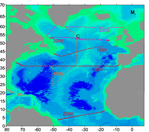
In 1999-2002, the Shirshov Institute of Oceanology carried out a number of cruises to the North and South Atlantic. The key objective of these cruises was the study of the seasonal and low frequency variability of the thermohaline structure of waters and the distribution of hydrochemical parameters in the entire depth range. The expeditions were carried out within the Federal Scientific Research Program "World Ocean" and in the framework of the continuing international cooperation within the WOCE-CLIVAR program. The chart of stations in shown in the figure
Significant variability of the thermohaline structure of waters in the World Ocean within the decadal scale was found on the basis of the field data gathered in the WOCE experiment and their comparison with the historical data. It was shown that the variations in the properties of seawater are found in the entire water column. They are recorded even at abyssal depths. The importance of this finding facilitated the fact that the international scientific community decided to continue the field measurements on a series of WOCE sections to study this variability in detail and finally to find its influence on the climate variations. During these years, the Shirshov Institute of Oceanology gathered a significant data set for the further study of the processes in the World Ocean, thus making a contribution of Russia to the WOCE-CLIVAR program.
Hydrographic conditions in the North Atlantic can be explained to a great extent by the type of prevailing atmospheric circulation over the ocean: either zonal or meridional. The general characteristics of the degree of atmospheric transport zonality is given by the North Atlantic Oscillation (NAO), which is determined as normalized difference between the atmospheric pressure between Iceland and the Azores. At high-index NAO western winds and number of cyclones increase in the Subpolar region of the North Atlantic, and the trajectories of the cyclones are oriented to the northeast. In winter, cyclones transport dry cold air from the continent to the ocean, inducing intense heat fluxes from the ocean. At high-index NAO this heat transfer process is intensified. At low-index NAO the winds become weaker. Anomalously low values of the NAO were observed in the 1960s, and anomalously high values were observed in the late 1980s - early 1990s.
A comparison of the data of several transatlantic sections, taken in the 1990s with the earlier measurements showed that a significant variability of water structure exists on a decadal scale. The formation of water masses in the North Atlantic is determined by local peculiarities of ocean--atmosphere interaction, topography of the bottom (thresholds and ridges), which forms obstacles to free water exchange with the Arctic Ocean, ice transport from the Arctic, and intensive meridional water exchange with lower latitudes in the Atlantic. The most important factor regulating heat transport in the ocean is the Meridional Overturning Circulation (MOC). The main elements of the MOC are sinking of cold heavy waters at high latitudes, transport of these waters to the south in the lower limb of the MOC and transport of warm waters to the north in the upper layer.
Earlier studies found that intensity of the MOC depends on the flow of deep waters of the Arctic origin and has a negative correlation with the intensity of Labrador Sea Water (LW) formation. During the last two decades it was found that two modes of the MOC exist in the North Atlantic. The periods of MOC intensification in the North Atlantic in the beginning of the 1980s and in the end of the 1990s alternated with the periods of weakening of the MOC system in the late 1950s and early 1990s. In the 1980s, the intensification of the MOC occurred on the background of a sharp decrease in LSW formation and increase of DSOW transport. As a result, a two-layer mode of the MOC was formed in the North Atlantic, which corresponds to an intensive transport of deep waters and a weak flow of LW. Weakening of MOC in the North Atlantic in the early 1990s occurred on the background of a sharp increase in the volumes of LW formation, freshening, cooling, and density increase of LW. Simultaneously, the volume of Denmark Strait Overflow Water (DSOW) transported to the south decreased. As a result, a three-layer mode of the meridional circulation cell was formed, in which an increased southern transport in the intermediate layer of LW weakened the intensity of MOC, and correspondingly, meridional heat transport in the North Atlantic was decreased (by 30 -40% with respect to the first regime).
The most important result of measurements in 2002 in contrast to the observations in the 1960s (previous minimum of the NAO) and to 1997 (cruise of R/V “Professor Shtokman”) is the recording of Charlie Gibbs water stream displacement to the east in the region between Greenland and Iceland due to the fact that DSOW occupies the place of Charlie Gibbs water in this region.
The research of spatial and temporary (interannual and seasonal) variability of thermohaline characteristics of Mediterranean Waters (MW) along 36° N section from 8° to 50° W was carried out on the basis of 174 hydrographic sections, taken by weather ships of the Russian Hydrometeorological Service. It is shown, that this section is representative for the description of MW propagation to the west (the section coincides with the maximum of the salinity tongue). In order to estimate the interannual and seasonal variability of water structure the integral characteristics of heat and salt content in a unit water column between 800 and 1500 m at the reference points of the section 10°, 20°, 30°, and 40° W were calculated. It is shown that positive climatic trend exists at 10° W (0.017 psu per year and 0.04°C per year). The trend is practically absent at 20° W. The negative trend at 30° W is low (--0.002 psu per year and --0.009°C per year). The analysis of the seasonal variability shows that the fluctuations of heat and salt content occur synchronously at all reference points with the maximum of their values in spring (March) and in the end of summer (August--September). The amplitude of the fluctuations decreases from east to west, which is determined by advection of MW in the western direction. The change in the climatic trend nature indicates that the decreasing of MW volume transport from east to west results in an increase of the northern flow transport. Later, these waters are involved into the circulation by the North Atlantic Current at intermediate depths and transported into the Arctic region.
The distribution of water masses and their properties in the Equatorial Atlantic was carried out using the new data obtained in July 2000 at the transatlantic hydrographic section approximately along 5°30’N during cruise 8 of R/V “Akademik Ioffe”. The most interesting features were found in Antarctic Intermediate Water (AAIW) and Antarctic Bottom Water (AABW): a significant upwelling of AAIW in the western part of the section and extremely low temperature of AABW west of the Mid-Atlantic Ridge. A 0.07°C decrease in the temperature of AABW compared to the measurements made in 1994 was found. The estimates of cross-section meridional mass transport and heat flux (0.53±0.16 PW for the July mean wind stress and 0.95±0.19 PW for the annual mean wind stress) show their consistence with the calculation made for the A6 WOCE section. However, the northward transport of the UNADW is opposite to previous estimates made for the 8°N and 14.5°N sections. The importance of mesoscale dynamical features in meridional transports at this latitude is emphasized. The estimates of volume transport in the North Brazil Current are close to 40 Sv. The southward transport of NADW is 12-14 Sv and the northward transports of AAIW and AABW is 4-5 Sv each. The northward transport of the UNADW is opposite to the previous results for the 8°N and 14.5°N sections.
In November 2002, during cruise 11 of R/V “Akademik Ioffe” a hydrographic section was carried out across the Vema Channel in the South Atlantic. Seven hydrographic stations were taken along 31°14’ S from 39°17’ W to 39°28.5’ W. Here, the major part of Antarctic Bottom Water transport to the north takes place through the deep water Vema Channel. The coolest bottom waters propagate through this channel because it is the deepest among the three existing pathways. The depths in the Vema Channel exceed 4600 m, while the background depths on the plateau, in which this channel is located, are about 4200 m. The width of the Vema Channel is about 15 km and the depth reaches almost 4700 m over the background of surrounding depths 4000--4200 m. It was found that the core occupies a major part of the channel width, which was not observed in the previous expeditions. The western boundary of the core displaced by 3--4 miles to the west compared to 1991. The previously observed trend to the warming of the cold jet core in the Vema Channel, which is recorded since the 1970s, is confirmed. In 2002, the minimum potential temperature in the core was equal to minus 0.123°C.
Such warming can be related to the general warming of surface waters, in particular in the Southern Hemisphere, which is observed since 1910. Beginning from 1910, combined mean temperature of land, air, and sea surface in the Southern Hemisphere was increasing. Since the water, which is now flowing through the Vema Channel, was formed in the Antarctic region more than 30 years ago, the general warming of AABW is observed from 1970.
Water dynamics and waves in the Arctic seas
The problems of calculating tidal dynamics characterized with long open boundaries and alternating of open and closed parts of the boundary circuit was considered on the example of the Barents Sea. The information obtained from large-scale models and from data of observations is used for the formulation of boundary conditions on the open boundary. The comparison of the obtained estimates with the data of deep water stations shows that the obtained estimates do not differ from the ones, given in other publications but they are worse than the ones obtained at several coastal stations on Novaya Zemlya Island and on the southern coast of the sea. Experimental calculations show that the quality of the boundary information has the dominating influence on the accuracy of the calculation because the interacting amphidromic systems of the sea are very sensitive to the accuracy of its presentation. Thus, an increase in the accuracy of modeling of the tidal dynamics of the Barents Sea is primarily associated with the possibilities of improving the large-scale model of the Arctic Basin.
The main elements of large-scale water structure in the Barents Sea are distinguished on the basis of observations: upper quasi-homogeneous layer, cold subsurface layer, and warm intermediate layer. The estimates of the spatial and temporal variability in the central and southeastern parts of the sea are presented. An estimate of the proportion between the temporal and spatial variabilities in the total variability of thermohaline characteristics in two study areas is elaborated. The influence of coastline configuration and rivers’ discharge on the formation of the structure of shallow waters is demonstrated.
Long-term time series of seawater density of the Atlantic origin, its oxygen saturation, and mineral phosphorus content were studied on the “Kola Meridian” section (70°30’-72°30’ N, 33°30’ E) in the southern part of the Barents Sea. Long-term variability of water density is characterized by periodical distortions in the synchronous time oscillations at different depths. Interannual variations in water aeration in the bottom layers are characterized by relatively deep minima of oxygen content intermittent with longer periods, when aeration slightly exceeds the “norm”. Oxygen content in seawater decreases with the growth of the water column density stratification. Phosphate concentration in the Atlantic waters increased from the beginning of the 1960s to the middle of the 1980s and later decreased to a long-term average value. A similar dynamics of phosphate concentration was observed in the other regions of the Northeastern Atlantic. Possible correlations between the long-term variability of the climate and density structure of water masses, chemical composition of bottom waters, production and biomass of plankton and fish in the ecosystem of the Barents Sea are discussed in the paper.
Physical and geological investigations in Saint Anna Trough were carried out in the course of the joint Russian--American--Norwegian expedition. The multidisciplinary character of the investigations consisted of the research in all main parts of the ecosystem: aerosols, fluxes of matter, suspension, water column, bottom deposits. Special attention was focused on the research in the water column with an objective to analyze the state of the oceanographic fields, determine the character of the geostrophic (density) circulation, and evaluate the peculiarities of water and heat exchange. The hydrographic measurements were carried out with a CTD profiler. The analysis of the horizontal and vertical variability of the main hydrophysical fields was carried out.
In the region of the Arctic coast, the barotropic tide generates an internal tide, whose influence most strongly manifests itself near different features of uneven bottom topography. The internal tide, even in the regions located south of the critical latitude, practically does not develop into a free propagating internal wave. The fluctuations of the isopycnal surfaces with significant amplitudes are observed only near bottom slopes. It is likely that here internal waves lose their energy, which is transferred to the energy of short-period waves and into the potential energy of the mixed water column.
The calculations made with the numerical model indicate that the bottom slopes characteristic of the region under study can lead to the generation of a forced internal tide. Since the stratification and bottom slopes are irregular, the internal wave field should also have a patchy structure. Maximum amplitudes are observed in the places where the inclination of the characteristic lines for the internal tides would randomly coincide with the bottom slope. In order to form large amplitudes of the internal tide, the bottom slopes should not necessarily be as steep as they should be in the regions of low and mid-latitudes. Due to the fact that the inclination of the curves of the characteristic equation for the internal waves in the Arctic latitudes is significantly smaller, large amplitudes of the internal tide can be generated even at small bottom inclinations. The proximity of the critical latitude for the internal tide, which is determined not only by the latitude of the place (approximately 75° N) but also by the vorticity of the currents, will play a significant role here.
Joint analysis of moored current measurements, numerical model calculations, and satellite images in the Strait of Kara Gates was carried out. The vertical internal displacements (double amplitudes) with a semidiurnal frequency are extremely large. They exceed 80 m, while the depth of the sea is about 200 m. The displacements are related to internal tidal waves over the sill crossing the strait. The energy of the internal tides is transferred to an internal bore and associated wave packets of short-period internal waves. Their surface manifestation can be seen on satellite images. Numerical modeling shows that in the Kara Gates, the flow from the Barents Sea to Kara Sea increases internal waves propagating in the southwestern direction. The internal tide propagating in the opposite direction to the flows intensifies and breaks down into shorter period waves that are seen on the satellite images.
The estimates of the main parameters for the transformation of internal waves field in the conditions of the Arctic Basin were carried out. Hydrographic data with one-degree resolution were used as the initial material. The geographical and seasonal variability of long internal wave velocity, dispersion parameter, quadratic, and cubic nonlinearity parameters was studied. The results are presented as charts of the distribution of model parameters and in the form of a table of characteristic values for each of the seas in the Arctic Basin. The calculated velocities of internal wave propagation for the majority of the regions in the Arctic Ocean (excluding some coastal regions and straits) exceed the values of background velocities of the currents so that as a first approximation the calculation of the characteristics of internal waves is possible only on the basis of the density stratification of the ocean. According to the calculations, internal waves in the Arctic Ocean are characteristic of negative quadratic nonlinearity and positive cubic nonlinearity. As a result, the solitons of internal waves of small amplitude should have negative polarity (bent to the bottom), waves of large amplitude can have any polarity. Spatial variability of the main parameters of internal wave model is related mainly to the geographical factors: variable depth, outflow of large rivers. At the same time, seasonal variability of the model parameters is not large and can be neglected as a first approximation.
A coupled ice-ocean model is developed for the study of the seasonal variability in the Arctic Ocean. The model characteristic features are elastic-plastic constitutive law for the description of the ice internal stresses, a distribution function for the ice mass and consolidation, and a special algorithm of a high degree accuracy approximation of the advective terms. Areas with local ice thickness maxima due to ridging are obtained in the calculations. The model reproduces formation of leads and polynyas, where intensive formation of young ice associated with salinity increase in the upper ocean layers occur. Frontal zones with high temperature and salinity gradients and local circulation near the ice edge as well as ice thickness distribution with two maxima corresponding to multi-year ice and young winter ice and summer leads are obtained.
A comparison between the bio-optical characteristics of the Barents Sea waters calculated from the ocean color data gathered by the SeaWiFS satellite scanner and the data simultaneously measured in situ in August--September, 1998, has shown that the SeaWiFS algorithms for atmospheric and bio-optical correction result in great errors in this region, especially in its southeastern part, where the chlorophyll concentration is overestimated several tens of times. A new bio-optical algorithm has been suggested, which provides much better agreement between the calculated and measured values of the chlorophyll concentration. An algorithm for restoring the index of backscattering by the suspended matter from the data of remote measurements of sea color is suggested. The measurements of the brightness coefficient were made in the Barents Sea. The values, restored using this algorithm, were compared with those, obtained using other methods for restoring the index of backscattering. A relationship between the index of backscattering and concentration of suspended matter is obtained. The spatial distribution of suspended matter in the Barents Sea obtained from the data of SeaWiFS ocean color scanner agree with the field in-situ data.
The Global Oceanic Conveyor
The mechanism of the formation of deep Atlantic waters in the Subpolar region of the Atlantic Ocean was studied. It was found that the waters of the East Greenland Current, Subpolar cyclonic gyre, and Irminger Current participate in the formation of these waters.
The deep conveyor track on the basis of calculations using the equation for transporting the neutral admixture was described. In addition to the initial Subpolar source of deep waters with a discharge of 10 Sv three more sources of deep waters in the northern part of the Atlantic ocean with the total transport of 10 Sv were found. Thus, 20 Sv of deep Atlantic waters participate in the conveyor. Antarctic deep waters of the Atlantic origin are formed as a result of diffuse interaction of deep conveyor waters with Antarctic deep waters.
Upwelling of deep conveyor waters occurs in the central part of the Subpolar cyclonic gyre in the Pacific Ocean, at the northern periphery of the Kuroshio extension, and in the equatorial zones of the Indian and Pacific oceans. The downwelling regions of the surface conveyor waters are located at the right boundaries of the Guyana Current, Gulf Stream, Irminger current, and Subpolar cyclonic gyre. The passing times of conveyor waters in individual intervals of its deep and surface tracks were calculated. We estimated the entire time of water circulation in the Global oceanic Conveyor.
Southern Ocean
Water masses of the Pacific Antarctic are studied on the basis of the WOCE S4 section carried out along 67°S. The data of temperature, salinity, oxygen, silicate, and phosphorus obtained with CTD profilers and Nansen bottles are studied. The boundaries between water masses are predominantly determined on the section as the position of maxima of the absolute values of the gradients of specific physical-chemical properties with respect to density. The mean and extreme values of the water masses parameters are determined. Some new results concerning the distribution and quantitative characteristics of the Pacific water masses are obtained. In particular, the paths of the propagation of the Bottom Antarctic Water formed in the Ross Sea and the peculiarities of its propagation are analyzed. No formation of bottom waters in the Amundsen and Bellingshausen seas was found.
The study of cyclonic Eddies at the Subantarctic Front and Formation of Antarctic Intermediate Water was carried out. A concept is developed, according to which the formation of Antarctic Intermediate water (AAIW) occurs due to frictional decay of cyclonic synoptic eddies generated as a result of the separation of cyclonic meanders at the Subantarctic Front (SAAF). A numerical model of this decay is formulated and calculations are carried out. An estimate of salt losses by the AAIW layer in the Pacific Ocean as a result of the formation of one pair of cyclonic and anticyclonic SAAF eddies is equal to 1/65 1012 kg. Assuming that the secondary contacts of the eddies with the SAAF are absent and specifying the coefficient of diapycnal mixing at intermediate depths equal to 0.1 cm2/s, we obtain that up to ten pairs of eddies of different sign, which are formed within a year at the Pacific sector of the SAAF, are enough to maintain the layer of AAIW in the Pacific Ocean in stable state.
Far Eastern seas
The structure and water dynamics in the region of the Kuril Straits is studied in the warm half of the year on the basis of data obtained by recent expeditions in 1989--1991 from the research vessels of the Pacific Institute of Oceanology, Far Eastern Branch of the Russian Academy of Sciences in the main Kuril Straits (Vries, Bussol, Krusenstern, Fourth Kuril). Thermohaline indices of the water masses comprising the structure of waters in the straits are determined. Characteristic distinctions of waters of different modifications (Okhotsk, Pacific, and transformed ones) are shown for each strait. Analysis of qualitative scheme of circulation in the straits and its variability is carried out. The dependence of formation of the water structure in the straits on the variability of water exchange through the straits is found.
The tidal load on the shelf of the Sea of Japan near Vladivostok is studied on the basis of field measurements obtained in different years by means of the laser measurements of the earth's crust and numerical calculations. A comparison of the lithosphere tidal deformations with those theoretically calculated has been performed. Qualitative and quantitative agreement between the field data and theoretical calculations has been found. A conclusion was made about the possibility of registration of tidal elevation of the Japan Sea level by laser strain meter.
The structure and intraannual variability of the layer of the North Pacific Intermediate Water (NPIW) are studied on the basis of analysis of more than one thousand hydrographic stations in the northwestern Pacific. NPIW is defined as a minimum on vertical profiles of seawater salinity. The absence of seasonal variability in the NPIW layer below 100 m is revealed together with a significant predominance of meridional variability of all the parameters over the zonal ones. A kinematic model of the NPIW layer, developed for the meridional section along 155°E showed the existence of water transport in the equatorial direction caused by vertical mixing. It allowed us to estimate the magnitude of the transport as 1 cm/s that gives the period of NPIW complete renewal equal to 10 years. It is also shown that vertical mixing induces density increase in the northern part of the layer while its buoyancy increases in the southern part. The formalism developed for the description of cabbeling allowed us to show that the contribution of this effect reaches 30% of the local changes of seawater density everywhere but not only in the Subarctic Front as it was considered before.
Internal mixing in a frontal zone characterized by slant isopycnic surfaces may disturb the existing geostrophic balance. The process of geostrophic adjustment to a new equilibrium state under the condition of conserving the stable vertical stratification of the ocean induces isopycnic motion within the narrow frontal zone. A simple model of the process is suggested that allowed us to estimate the intensity of the motions. A conclusion is made on the basis of observations in the Kuroshio and the North Pacific Subarctic Front about an important role of cabbeling in the generation of the frontal convection, formation of the North Pacific Intermediate Water and frontogenesis. It was shown that the data of surface drifters does not contradict this conclusion. This physical mechanism as well as subduction may determine the ventilation of the main thermocline of the World Ocean.
A concept of a background current which was earlier used for calculation of the barotropic circulation in the Sea of Japan is generalized for the case of a two-layer fluid in the quasi-geostrophic approach. The account of baroclinity leads to visible reduction of the amplitudes of the stream function and allowed us to reproduce most of the qualitative peculiarities of the horizontal structure of the Tsushima current.
The analysis of thermohaline structure and space-time variability of the St. Paul Island coastal frontal zone is carried out on the basis of two hydrographic surveys made with a interval of approximately 1.5 months. It is shown that the difference in the structure of the frontal zone found between the two surveys were determined by the seasonal variability in the thermal condition of the ambient waters. Peculiarities of cross-frontal exchange under conditions of different structure of the frontal zone are discussed. Summarized characteristics of the coastal frontal zone are given.
A transition from one thermohaline state into another one in the western Subarctic Region of the Pacific Ocean was described. Such transition occurring in time actually signifies climatic variability. The data used were obtained in 1990--1996 in the INPOC, WOCE projects and “Subarctic” program of the Pacific Institute of Oceanology. The thermohaline properties of the Oyashio and its large anticyclonic eddies were accepted as the indices of variability. The observations show that the ventilation of the intermediate layers in the Western Subarctic region (200--1000 m) occurred in the end of the 1980--1990s due to an inflow of warm and saline waters of Kuroshio into the Sea of Okhotsk and Oyashio region together with a weakening of the water transport by the coastal branch of the Oyashio. From 1991 to 1997 there was a transition period to a “cold epoch”. The changes that occurred in the Subarctic region appeared the greatest among the observed by present in the World Ocean. Strong stratification in the Oyashio region became a consequence of the thermohaline transition. Subarctic waters almost completely forced out the warm subtropical waters which earlier flowed into the Sea of Okhotsk from the Sea of Japan through La Perouse (Soya) Strait. A transition from a warm epoch into a cold one occurred by means of strengthening of the western (coastal) branch of the Oyashio (Coastal Oyashio).
A primitive non-linear model of marine currents in the spherical sigma-coordinate system is presented. The model describes a wide spectrum of motions including wind currents, tidal waves, and thermohaline circulation. The numerical algorithm of the model was developed on the basis of economical methods of splitting and balance grid approximations. The combination of implicit methods of splitting and special spatial digitizing increases economical properties of the model and allows us to use it for numerical experiments in a wide range of input parameters. The model is realized for the basin of the Okhotsk Sea with grid resolution over longitude and latitude 10’x15’ and 15 vertical levels. The motion is forced by wind stress, non-uniform heating, and salination at the sea surface, as well as by tidal oscillations of the sea level at the open boundary along the Kuril Islands. The results of the calculation of K1 wave and a full baroclinic model are presented. Numerical experiments indicate that the model realistically reproduces the structure of hydrographic fields in the Okhotsk Sea.
Black Sea
The role of general circulation and eddy structures in the ventilation of the Black Sea aerobic waters is shown on the basis of experimental data (hydrographic surveys and sections). In the course of the autumn-winter convection, direct contact between aerobic and anaerobic waters and their ventilation occurs in the cyclonic gyres and cyclonic eddies in the center of the sea. In the other regions of the sea the ventilation of anaerobic waters occurs due to cold intermediate waters (CIW) enriched with oxygen, which are transported from the regions of their annual formation by currents. CIW spread all over the whole basin, including the coastal zone. The Rim Cyclonic Current (RCC) and nearshore anticyclonic eddies favor the deepening of the upper boundary of the hydrosulfide zone.
The analysis of satellite images and CTD measurements carried out from R/V “Akvanavt” over the continental slope showed that two anticyclonic eddies can exist together in the layer 0—300 m without coalescing. One of the eddies was a quasi-stationary one, while the other had a comparatively short lifetime (1.5 months). The diameters of eddies were 90 and 55 km, respectively. Collapsing of the less intensive anticyclone occurred, when it was displaced to the shelf area by the quasi-stationary eddy. Formation of a cyclone to the north of the anticyclonic pair of eddies, when they draw together leads to the appearance of counterflow streams between the eddies of different signs both in the upper layer (0—150 m) and at grater depths with the core of the stream located at a depth of 150 m. This facilitates horizontal exchange between the shelf and the open part of the sea.
Intensification of the Black Sea Rim Current is caused by wind (Ekman) energy input. It is accompanied by decreasing of mesoscale eddy dynamics and related horizontal water exchange and ventilation of polluted shelf waters whereas the relaxation of the Black Sea Rim Current at weak winds leads to an opposite effect. This conclusion is a result of joint analysis of wind, satellite images, field observations, drifter data, and laboratory modeling of mesoscale dynamics in the Black Sea.
A box-balance model is developed for the Black Sea water exchange estimations. The model consists of three blocks: Bosporus, shelf, and open sea. Balance relations of water, salt and mechanical energy of turbulent mixing are written for each box within the quasi-stationary approximation. The solutions of the algebraic equations for the water volume fluxes between the boxes and characteristic thickness of the upper quasi-homogeneous sea layer were found and analyzed. The tendencies of the possible anthropogenous influence on the condition of water environment over the Black Sea shelf are discussed.
A simple physical mechanism for the formation of stationary turbulent mixed layer was demonstrated in a series of laboratory experiments. A quasi-homogeneous layer of foam was formed, when a sufficiently intensive jet of water was poured into a vessel. It was shown that the thickness of the foam layer was not only proportional to the Monin-Obukhov’s length scale, which is usually assumed for the upper quasi-homogeneous layer under natural conditions, but it was also proportional to the Reynolds number. A simple box balance model was used within the framework of an idealized problem to study the dependence of the thickness and salinity of the upper layer on external parameters. Quantitative estimates were obtained on the basis of a review of the literature data on the measurements made in the Black Sea.
Field measurements of anthropogenic pollution of seawater and bottom sediments were carried out. Experiments showed that the spreading of pollutants is patchy. The characteristic time of the existence of patches is equal to a few days. It is determined by the rate of advective and diffusive processes. The traces of radioactive pollution in bottom sediments caused by nuclear tests in the 1960s were found. The pollution after the Chernobyl accident in 1986 was increasing during 5-7 years and after this the level of pollution started to decrease. The major part of pollutants transported into the sea depends on the duration of the previous dry period and amount of rains and river outflow. Bottom sediments are the best indicators of accumulation of pollutants.
The correlation and spectral structure of wind waves in the Black Sea are studied. The statistical properties of steady conditions interpreted as “storms” and “weather windows” are investigated. A genetic classification by types of waves and classes of storms is proposed. An estimate of the probability of each of the classes and transformation between the classes is evaluated.
Caspian Sea
The Princeton Ocean Model was used to investigate the formation and evolution of a temperature anomaly in the coastal zone. The conditions of warm water discharge from a continuous source, simulating a power plant, were modeled for the shallow waters of the Caspian Sea (Apsheron Peninsula). A study of the behavior of warm water jet was performed for the real bottom topography and hydrometeorological conditions typical for the region under study. A multidisciplinary numerical model was developed to describe the behavior of non-conservative tracers in the sea with an application to oil slicks resulting from accidental discharges of oil. Coastal waters north of the Apsheron Peninsula were chosen as an example for the numerical study. Our model is based on the Monte-Carlo method. It includes real bottom topography, as well as characteristic thermohaline profiles of this region. Various factors influencing the oil slick evolution, such as specific properties of oil and the hydrodynamic features of the region are modeled. The latter are simulated by means of a modified, 3D multi-layered, primitive equation model known as the Princeton Ocean Model. The coastal water dynamics and oil slick transport are studied for various meteorological conditions and discussed with the objective to provide a reliable risk assessment of oil spill impacts.
Baltic Sea
A numerical model of the ocean circulation by Blumberg and Mellor (POM) is applied to study the formation of mesoscale cyclonic eddies in the Baltic Sea, which follows the inflow events of North Sea water. Prognostic calculations show that an intense cyclonic eddy is generated east of the Stolpe Furrow when inflow waters spread into the Gotland Deep through the Stolpe Furrow. A similar cyclonic eddy is formed when the inflow waters enter the Bornholm Basin from the Arkona Basin. A number of smaller cyclonic eddies with lenses of saline inflow water are formed in the intermediate layer along the saline intrusion pathway to the Gotland Deep. Model runs with constant and time dependent wind forcing, different inflow intensity, grid configuration, and bottom topography of the basins confirm the hypothesis that the cyclones are formed by the geostrophic adjustment of the inflow water column with high potential vorticity to a low potential vorticity environment.
The characteristics and mechanisms of generation of finestructure intrusions in the halocline of the Baltic Sea are studied on the basis of CTD-profiling with increased vertical resolution carried out after a great inflow of waters from the North Sea in 1993. Salt fingering process is not possible and convection at the diffusive interface has a limited effect on the intrusive interleaving of the halocline due to the strong prevalence of the contribution of salinity over temperature into the vertical density stratification. An indirect evidence of the generation of intrusions by inertial oscillations was found. In several occasions we observed odd intrusion-like structures crossing isopycnal surfaces in such a way that the density relation calculated from the changes of temperature and salinity along the intrusion coincided with the vertical density relation. We show that it is not likely that these “odd intrusions” were generated by the interleaving process in its traditional concept and suggest several scenarios for their formation.
Publications in the “Okeanologiya” (Oceanology) Journal in 1999-2002
Vol. 39, No. 1, 1999
Water Masses of the Pacific Antarctic, M.N. Koshlyakov and R.Yu. Tarakanov
Numerical Modeling of Extreme Seiches in the Region of the Balearic Islands
A.B. Rabinovich, S. Monserrat, and I.V. Fain
Numerical Modeling of the Dynamics of the Layer of Fresh Riverine Water in the Kara Sea
S.L. Meshchanov
On the Influence of Stratification and Ventilation on the Dynamics of the Subtropical Circulation
A.P. Mirabel and A.M. Mishina
Eddy Water Structure in the Southern Okhotsk Sea and Its Seasonal Variability (Results of Satellite Monitoring)
N.V. Bulatov, L.A. Kurennaya, L.S. Muktepavel, M.G. Aleksanina, and E.E. Gerbek
Structure of the Geostrophic Currents in the Northeastern Black Sea
V.B. Titov
Tidal Internal Wave Propagation over Large Distances in the Indian Ocean
E.G. Morozov, V.I. Vlasenko, T.A. Demidova, and V.V Ledenev
Undertow in the Near-Shore Zone
L.O. Leont'ev
Vol. 39, No. 2, 1999
Internal Waves at the Slope of Bear Island from the Data of the Barents Sea Polar Front Experiment (BSPF-92)
G.I. Kozubskaya, K.V. Konyaev, A. Plueddemann, and K. D. Sabinin
On the Origin of the Subsurface Maxima of DOM Fluorescence in the Active Layer of the Open Ocean
G.S. Karabashev
Basic Phases of Separation of Near-Bottom Gravity Currents from a Sloping Bottom
V.A. Gritsenko and A.A. Yurova
A Model for Calculation of Ultraviolet Radiation Transfer in Arctic Waters
A.P. Vasilkov, O.V. Kopelevich, N.A. Krotkov, S.V. Sheberstov, V.I. Burenkov, and S.V. Ershova
Influence of Synoptic Vertical Currents on the Distribution of Chlorophyll a Concentration in the Black Sea
V.M. Kushnir, O.A. Yunev, and Z.Z. Finenko
Forecasting of Pollutant Spreading from Sites of Disposal in Marine Environments
V.K. Goncharov and N.Yu. Klement'eva
Vol. 39, No. 3, 1999
On the Generation of Subsurface Motions over a Sloping Bottom in a Two-Layer Ocean
G.M. Reznik
Residual Water Transport by Longshore Tidal Currents along the Coast in Shallow Water
V.N. Zyryanov and A.B. Reshetkov
Data Assimilation in a Finite Element Model of M2 Tides in the Barents Sea
A.L. Kurapov and G.A. Kivman
A Model of Seawater Optical Properties in the UV Spectral Range in Light of New Data
S.V. Ershova and O.V Kopelevich
Observations of the Gulf Stream Frontal Zone Using a SAR on ALMAZ-1 Spacecraft and Measurements Aboard R/V Akademik Vernadskii
S.A. Grodsky, V.N. Kudryavtsev, and A.Yu. Ivanov
Vol. 39, No. 4, 1999
Generation Mechanisms of Intrusive Finestructure in the Baltic Sea
V.M. Zhurbas, V.T. Paka, and G.A. Koshkosh
Modeling of the Seasonal Variability in the Arctic Ocean
I.V. Polyakov
Oceanographic Investigations in the Saint Anna Trough (Kara Sea)
G.I. Ivanov and A.V Neshcheretov
Thermohaline Analysis of the Conditions for Increasing and Decreasing of Density during Seawater Mixing
Ye.Yu. Klyuikov, P.P. Provotorov, and K.B. Utkin
Current Diagnosis over the "Diffuziya-84" Test Area at the Western Shelf of the Black Sea
D.I. Trukhchev, D.V. Ivanov, and R.A. Ibraev
Vol. 39, No. 5, 1999
Oceanological Research of the World Ocean in Russia
S.S. Lappo
Pages in the History of Experimental Research of Ocean Physics Performed in the Russian Academy of Sciences
V.G. Neiman
A Comparative Analysis of Intrusive Stratification in Cyclonic and Anticyclonic Meanders in the Azores Frontal Zone
N.P. Kuzmina, V.T. Paka, and V.M. Zhurbas
On the Potentialities of an Objective Classification of Vertical Profiles of DOM Fluorescence in the Active Layer of the Ocean
G.S. Karabashev
Vol. 39, No. 6, 1999
Kinetic Equation for Weakly Nonlinear Surface Waves in a Sea Covered with Broken Ice
I.V. Lavrenov, V.G. Polnikov, and V.P. Krasitskii
On the Diffusion of a Plankton Patch in a Turbulent Ocean
S.V. Petrovskii
"Variable" Karman Constant as a Parameter of Sedimentary Stratification
B.A. Kagan, W. Schrimpf, and K.B. Utkin
Variability of Tidal Internal Waves in the North Pacific on the Basis of WOCE Hydrographic CTD Data
E.G. Morozov
Atlantic Water in the Northeastern Part of the Barents Sea
K.V. Lebedev
Tidal Year and Time Systems
A.I. Duvanin
Vol. 40, No. 1, 2000
Meridional Transfer of the Freshwater Component in the Atlantic Ocean and Its Intraannual Variability
V.F. Dubravin
Physical Modeling of the Upper Quasi-Homogeneous Sea Layer
S.N. Dikarev and S.G. Poyarkov
Modeling of the Passive Admixture Transfer by the Eddy Currents in the Eastern Part of the Black Sea
R.A. Ibraev, V.I. Kuksa, and A.Yu. Skirta
Vol. 40, No. 2, 2000
Regional Variability of the Sound Field Temporal Structure in the Underwater Sound Channel
R.A. Vadov
Small-Scale Turbulence in the Near-Surface Layer of the Southern Baltic Sea
V.D. Pozdynin
Distortions of Hydraulic Jumps during Their Propagation along a Bottom Irregularity
B.K. Tkachenko and M.V. Bereznikova
On Evaluating Some Parameters of Traveling Surface Bodies from the Data of Remote Sensing of Their Wake
G.V. Smirnov and V.E. Veden’kov
Sea-Truth Measurements of the Ocean Color: Field Studies in the Black and Aegean Seas
V.A. Artemiev, V.I. Burenkov, S.V Woznyak, A.V. Grigoriev, M. Daretsky, A. Demidov, O.V. Kopelevich, O.N. Frantsuzov, and A.N. Khrapko
Vol. 40, No. 3, 2000
Two Dimensional Approximation of the Wind-Wave Interaction Parameter
M.Yu. Belevich and I.A. Neelov
Transport of Fine Sediment with Mesoscale Currents in the Shelf-Slope Zone of the Sea
G.I. Shapiro, T.M. Akivis, N.V. Pykhov, and S.A. Antsyferov
Conditions of Convective Instability in the Near-Surface Layer of Salt Water
L.Kh. Ingel
Peculiarities of the Water Dynamics and Chlorophyll a Distribution in the Northeastern Part of the Black Sea in Autumn 1997
A.I. Ginzburg, A.G. Kostianoi, V.G. Krivosheya, N.P. Nezlin, D.M. Soloviev, S.V Stanichnyi, and V G. Yakubenko
Sea-Truth Measurements of the Ocean Color: Validation of the SeaWiFS Satellite Scanner Data
V.I. Burenkov, O.V. Kopelevich, S.V. Sheberstov, and V.I. Vedernikov
Vol. 40, No. 4, 2000
Anisotropic Optimization of the Current Field with the Variational Method
G.G. Panteleev, N.A. Maksimenko, B. de Young, C. Reiss, and T. Yamagata
Small-Scale Turbulence in the Cross Sections of the Antarctic Circumpolar Current
V.D. Pozdynin
Modeling the-Process of the Temperature Anomaly Formation in the Coastal Zone of the Caspian Sea
K.A. Korotenko and R.M. Mamedov
Tsunami in the Caspian Sea: Seismic Sources and Features of Propagation
S.F. Dotsenko, L.R. Kuzin, B.V. Levin, and O.N. Solov'eva
Application of Empirical Orthogonal Functions for Estimating the Influence of Biological Characteristics on the Synoptic Variability of the Strength of Sound Volume Backscattering in the Tropical Atlantic
Yu.N. Tokarev
Vol. 40, No. 5, 2000
Distribution Functions of the Tsunami Run-up Heights (From the Data of International Expeditions of 1992-1998)
E.N. Pelinovsky and I.A. Ryabov
Modeling of Wave and Current Transformation in the Near-Shore Zone of the Sea
V.M. Shakhin and T.V. Shakhina
Modeling of Long Waves in The Sea of Azov Generated by Cyclone Propagation
V.N. Eremeev, A.V. Konovalov, Yu.V. Manilyuk, and L.V. Cherkesov
Modeling of Water Exchange Dynamics in the Stolpe Channel of the Baltic Sea
M.V Anisimov, V.M. Zhurbas, V.T. Paka, M.M. Subbotina, and G.A. Koshkosh
Probabilistic Response of the Atmosphere of the Northern Hemisphere to El Nino Events
V.I. Byshev and M.M. Lebedev
On the Estimate of the Water Exchange Processes in the Black Sea on the Basis of a Balance Model
S.N. Dikarev and S.G. Poyarkov
Vol. 40, No. 6, 2000
Nonlinear Internal Waves in the Ocean Stratified in Density and Current
E.N. Pelinovskii, O.E. Polukhina, and K. Lamb
The Influence of Circulation and Eddies on the Depth of the Upper Boundary of the Hydrogen Sulfide Zone and Ventilation of Aerobic Waters in the Black Sea
V.G. Krivosheya, V.B. Titov, I.M. Ovchinnikov, R.D. Kos'yan, and A.Yu. Skirta
Dependence of the Formation of the Winter Hydrological Structure in the Black Sea on the Severity of Winter Conditions
V.B. Titov
Evolution of a Near-Bottom Lens Based on Numerical Simulation
V.A. Tsarev
Vol. 41, No. 1, 2001
Transformation of the Profiles of Turbulent Diffusivity in a Developing Density Flow
B. I. Samolyubov
Peculiarities of the Thermohaline Structure and Variability in the St. Paul Island Coastal Frontal Zone (Pribilof Islands, Bering Sea)
S.G. Poyarkov and M.V. Emel’yanov
Wave Structure of the Oceanic Submesoscale Eddies
K.G. Vmogradova, L.M. Fomin, and A.D. Shcherbinin
Fine Vertical Shear Structure of the Currents in the Tropical Zone of the Atlantic Ocean
V.D. Pozdynin
Spatial Structure of the Sound Velocity Field in the Region of the Kuril-Kamchatka Current
V.V. Moroz and F.F. Khrapchenkov
Modeling of the Oil Slick Transport Processes in the Coastal Zone of the Caspian Sea
K.A. Korotenko and R.M. Mamedov
Vol. 41, No. 2, 2001
Climatic Mass, Heat, and Salt Exchange between the Arctic and North Atlantic
M.V. Anisimov, Yu.A. Ivandv, and M.M. Subbotina
Estimates of the Velocity Spatial Spectra of the Ocean Currents on the Basis of Drifter Data
V.M. Zhurbas and I.S. Oh
Several Approaches to the Investigation of Tidal Internal Waves in the Northern Part of the Pacific Ocean
E.G. Morozov
On the Mechanisms of the Origin and Development of Free Convectivc Motions in Water Cooled from the Surface
E.P. Anisimova, L.V. Petrenko, A.A. Speranskaya, S.N. Dikarev, and O.A. Speranskaya
On the Conversion of Wave-Gauge Pressure Data to the Spectrum of Surface Waves
M. M. Zaslavskii and V. P. Krasitskii
Anomalous Phenomena in the Atlantic Ocean in February-May 1998
N.P. Bulgakov, Yu.V. Artamonov, V.A. Bibik, V.E Grischenko, P.D. Lomakin, Yu.I. Popov, and V.V. Ukrainskii
Vol. 41, No. 3, 2001
New Data on the Current Regime on the Shelf of the Northeastern Black Sea
V.G. Krivosheya, V.B. Titov, I.M. Ovchinnikov, L.V. Moskalenko, A.Yu. Skirta, and V.V. Monakhov
A Method for Estimating the Penetration of Solar Visual and Ultraviolet Radiation into the Waters of the Arctic Seas Using Satellite Data: The Case of Cloudless Atmosphere
S.V. Ershova, O.V. Kopelevich, S.V. Sheberstov, V.I. Burenkov, and A.N. Khrapko
Variability of the Active Layer in the North Atlantic from Hydrologic Data and Values of Heat and Moisture Fluxes at the Surface
L.E. Ametistova, S.A. Dobrolyubov, and S.K. Gulev
On the Vertical Structure of Three-Dimensional Intrusive Interleaving of the Oceanic Fronts with High Baroclinicity and Thermoclinicity
N.P. Kuzmina
Tsunamis in the Caspian Sea: Numerical Modeling of Tsunami Propagation from the Zones of Seismic Generation
S.F. Dotsenko, L.P. Kuzin, B.V. Levin, and O.N. Solov'eva
Vol. 41, No. 4, 2001
Application of the Ocean Color Data Gathered by the SeaWiFS Satellite Scanner for Estimating the Bio-Optical Characteristics of Waters in the Barents Sea
V.I. Burenkov, V.I. Vedernikov, S.V. Ershova, O.V Kopelevich, and S.V. Sheberstov
Peculiarities of the Temperature Field in the Cold Intermediate Layer of the Black Sea
S.G. Boguslavsky, S.I. Kazakov, M.G. Perov and E.V. Berestovaya
Thermodynamical Response of the Upper Layer of Salt Water to Inhomogeneous Warming and Salination
L.Kh. Ingel
Modeling of the Near-Bottom Water Propagation in the Baltic Sea
V.A. Tsarev
Vol. 41, No. 5, 2001
A Study of the Sensitivity of the Model of the Black Sea Current Dynamics to the Surface Boundary Conditions
R.A. Ibraev
An Estimate of the Distribution of Suspended Matter in the Barents Sea Waters on the Basis of the SeaWiFS Satellite Ocean Color Scanner
V.I. Burenkov, S.V ershova, O.V. Kopelevich, S.V. Sheberstov, and V.P. Shevchenko
Water Structure in the Rainbow Rift Valley and Hydrothermal Plume
D.L. Aleinik, V.N. Lukashin, A.Yu. Lein, and I.A. Filippov
Method for Calculating Wave Diffraction and Refraction
V.M. Shakhin and T.V. Shakhina
Tidal Motions and Admixture Transport in the Estuary of the Onega River
R.E. Zdorovennov, V.Kh. Lifshits, and V.R. Fuks
Vol. 41, No. 6, 2001
Mathematical Modeling of Transport and Sedimentation of Technogenous Particles in the Sea of Azov
S.V. Berdnikov, O.V. Ivlieva, and V.V. Prudnikova
Structure of the Transparency Field and Features of Its Formation in the Upper Layer of the Caucasian Coastal Zone in the Spring-Summer Period
E.A. Agafonov, A.S. Kukushkin, and Yu.A. Prokhorenko
Parameteri/ation of the Coriolis Force in a Numerical Model of the Seasonal Evolution of the Hydrodynamics of the Black Sea
A.A. Kordzadze and A.C. Girgvliani
Vol. 42, No. 1, 2002
Water Structure in the Equatorial Atlantic on the Basis of the Year 2000 Transatlantic Section
A.V. Sokov, E.G. Morozov, S.M. Shapovalov, S.O. Borodkin, and T.A. Demidova
Water Dynamics in the Norwegian Sea at the Site of the Accident of the Komsomolets Nuclear Submarine
D.L Aleinik, V.I. Byshev, and A.D. Shcherbinin
A Method for Estimating The Penetration of Solar Radiation into the Waters of the Arctic Seas Using Satellite Data: The Case of a Totally Overcast Sky
S.V. Ershova, O.V. Kopelevich, and S.V. Sheberstov
Vol. 42, No. 2, 2002
Internal Tides at the Arctic Latitudes (Numerical Experiments)
E.G. Morozov and S. V Pisarev
Thermohaline Variability and Convective Gravity Currents in the Region of Coastal Polynyas in the Laptev Sea
P.N. Golovin
Some Results of the Measurements of the Phase Shift Formed at the Acoustic Signal Contact with the Caustic
R.A. Vadov
Atlas of Harmonic Constants of the Seasonal Variability of Hydrometeorological Elements in the North and Central Atlantic
V.E. Dubravin and S.E. Navrotskaya
Vol. 42, No. 3, 2002
Abyssal Path of the Global Ocean Conveyor
M.V. Anisimov, Yu.A. Ivanov, and M.M. Subbotina
Horizontal Structure of the Subarctic Front between Japan and 180° from Satellite and Oceanographic Observations
V.B. Darnitskii and N.V. Bulatov
A Study of the Effect of a Near-Shore Upwelling on the Dynamics of Oxygen and Hydrogen Sulfide Fields in the Shelf Zone of the Black Sea
V.I. Vlasenko, N.M. Stashchuk, V.A. Ivanov, A.S. Romanov, and Yu.L Vnukov
An Experimental Study of the Near-Shore Evolution of Wave Groups
S.Yu. Kuznetsov and Ya.V. Saprykina
Vol. 42, No. 4, 2002
Large-Scale Circulation in the Pacific Sector of the Southern Ocean Reconstructed with Variational Methods
A.S. Grotov and M.I. Yaremchuk
Studies of the Features of Detachment of Particles with Shifted Centers of Mass
S.G. Beloshapkova
A Model of the Transport of the Sediments Suspended by a Tidal Flow in the Coastal Zone of the Sea
S.M. Antsyferov and T.M. Akivis
Vol. 42, No. 5, 2002
The Global Oceanic Conveyor
M.V. Anisimov, Yu.A. Ivanov, and M.M. Subbotina
Interannual Variability of the Intermediate North Atlantic Water Circulation from a Multiparameter Analysis of the Water Masses
S.A. Dobwlyubov and A.S. Falina
A Numerical Model of the Wind, Thermohaline, and Tidal Currents in the Sea of Okhotsk:
V.B. Zalesny and S.E. Kontorovskii
Characteristics of the Main Black Sea Current and Near-Shore Anticyclonic Eddies in the Russian Sector of the Black Sea
V.B. Titov
Vol. 42, No. 6, 2002
Generation of Mesoscale Cyclonic Eddies in the Baltic Sea during the Inflows of the North Sea Water
V.M. Zhurbas, I.S. Oh, and V.T. Paka
On the Mechanisms of the Cyclic Climate Changes in the Arctic and the Antarctic
Z.M. Gudkovich and E.G. Kovalev
Reconstruction of the Winter Fields of Temperature and salinity in the Arctic Ocean
O.M. Pokrovskii and L.A. Timokhov