RUSSIAN ACADEMY OF SCIENCES
NATIONAL GEOPHYSICAL COMMITTEE
NATIONAL REPORT
to the International Association of Seismology
and Physics of the Earth’s Interior
of the International Union of Geodesy and Geophysics
1995 – 1998
1999 Moscow
The national report presents major results obtained by Russian scientists studies during the time period from 1995 through 1998 in the research fields relevant to the International Association of Seismology and Physics of the Earth’s Interior, International Union of Geodesy and Geophysics. Results obtained on the seismological network of the Russian Federation are described, and prospects of the network development are outlined. Results obtained from studies of major earthquakes that occurred in Russia during the period from 1994 through 1998 are presented, and the progress in seismic hazard assessment and earthquake prediction research is summarized. Main achievements in fields of geodynamics, mathematical and theoretical geophysics, geothermal research, and physical properties of the Earth’s material are characterized. Basic features of created geophysical information systems are described. International cooperation activities of Russian geophysicists are characterized. Pertinent literature references are presented.
Publication of this report was supported by the Schmidt United Institute of Physics of the Earth and by the Russian Foundation for Basic Research, project no. 99-05-78073.
Editorial Board
M.V.Nevskiy (Chief Editor), A.D.Zavyalov (Deputy Chief Editor), A.O.Gliko, A.F.Grachev, I.V.Kuznetsov, V.I.Ulomov, E.A.Khrometskaya (Scientific Secretary).
У
National Geophysical Committee RAS, 1999г.
Contents
Introduction M.V. Nevsky
*1. System of seismological observations in Russia
*1.1. System of seismological observations: Current status
O.E. Starovoit *1.2. Investigations into development of the seismological observation system
M.V. Nevsky *2. The Strongest Earthquakes that Occurred in the Territory of Russia in Recent Years
S.S. Arefiev *3. Seismic hazard of the Nothern Eurasia
V.I. Ulomov *4. Earthquake prediction
G.A. Sobolev, A.D. Zavyalov *5. Geodynamics
*5.1. Main results of investigations into geodynamics and neotectonics
A.F. Grachev *5.2 A new mechanism of global geodynamic processes
V.P. Trubitsyn *5.3. Tides and nutation of the Earth
S.M. Molodensky *6. Geothermal studies
A.O. Gliko *7. Earthquakes mechanisms and dynamics of seismicity
I.V. Kuznetsov *8. Experimental studies of physical properties of rocks and minerals at high pressures and temperatures
G.A. Efimova, S.M. Kireenkova *9. Information Technologies and Systems for Complex Analysis of Space-Time Properties of Geological Environment
V.G. Gitis *10. Participation of Russian scientists in international organizations and projects during the time period from 1995 through 1998
N.V. Kondorskaya *
М.V.Nevsky.
National Geophysical Committee, Schmidt United Institute of Physics of the Earth, Russian Academy of Sciences, B.Gruzinskaya, 10, Moscow 123810 GSP, Russia.This report submitted to the International Association of Seismology and Physics of the Earth’s Interior, IUGG, presents major results of investigations conducted by Russian geophysicists during the period from 1995 through 1998 in various fields of seismology, geodynamics, mathematical and theoretical geophysics, geothermal research, and physical properties of the Earth’s interior.
The main problems of this time period were related to the completely inadequate financing of basic research in geophysics, which resulted in quite appreciable reduction in works on several very important scientific programs, “migration” of geophysicists of high qualification to other spheres of activities, and dramatic reduction in research works on experimental geophysics and, in particular, experimental seismology.
However, the long-term experience and large potential of seismological research was retained in Russia over this time period. Stable relations and data exchange with seismologists in the CIS states were not broken. Implementation of the Federal development program of the Russian seismological observation system and earthquake prediction made it possible not only to stop the forced shutdown of seismic stations, but even to increase the number of working stations as compared with the period from 1994 to 1995.
The most important results of the works conducted from 1995 through 1998 are presented in ten sections of the present report. They are furnished with rather extensive reference lists of Russian and foreign publications of Russian geophysicists, including works performed in cooperation with foreign colleagues.
The following results included in this report appear to be most interesting and significant.
Other, quite important results presented in the report are developments in the dynamic theory of seismic processes, mathematical modeling of plate and plume tectonics, and novel applications of low-aperture seismic antennas.
The editorial board of the report hopes that many results of Russian geophysicists, only briefly mentioned in this report, will be immediately presented by authors to the XXII General Assembly.
1. System of seismological observations in Russia
This section briefly describes the current state of the seismological observation system on the territory of the Russian Federation and the studies designed for further development of the national seismological observations.
1.1. System of seismological observations: Current status
О.Е.Starovoit.
Geophysical Survey RAS. Obninsk, Кaluga region, Russia.During the period from 1995 through 1998, seismological observations on the territory of Russia were mostly conducted on the seismological networks of the Geophysical Survey, Russian Academy of Sciences (GS RAS), created in 1993. Main DS RAS targets are as follows:
One of the main results of the GS RAS activities during 1995 through 1998 is the issue of yearly (and, later, half-yearly) reports containing summarized information of Express seismological catalogs from data gathered by field expeditions and teams, with time delay amounting to 1.0-2.0 months after the event occurrence moment.
The GS RAS system of seismological observations includes one teleseismic network and eight regional and five local seismic networks of experimental expeditions and parties (EEP) that conduct seismic monitoring in specific regions. In all, 155 seismic stations presently operate within the framework of the GS RAS system (including the network of the GS RAS Siberian Division), with several instrumentation kits being used for parallel recording at some of the stations. The system includes 121 analog (teleseismic, regional, and local), 13 digital, and 39 telemetering stations.
The GS RAS seismological observations on the territory of Russia may be subdivided into three types: teleseismic, regional, and local.
Teleseismic network. The network implements seismic monitoring of M і 4.5 earthquakes on the territory of Russia and CIS states and is employed for global seismological observations of Earth’s catastrophic earthquakes.
The teleseismic survey is equipped with analog (SKM and SKD) and digital (IRIS) instruments. The latter were afforded by the California university, San Diego (IRIS/IDA), and the US Geological Survey (IRIS/ASGS).
Joint treatment of teleseismic data provide information for the Express Seismological Catalog and Seismological Bulletin, including earthquakes with M і 3.0-4.0 in Russia, with M і 4.5-5.0 in CIS states, and with M і 6.5 in the world; these publications present main parameters (occurrence time, coordinates, depth, magnitude, intensity) of earthquakes that occurred in Russia, CIS states, Eurasia, and adjacent areas (Carpathian- Balkan region, Mediterranean, North Africa, Turkey, Iran, Afghanistan, India, China, Japan, and Aleutian Islands), provided that records from three or more stations are available.
At the same time, seismicity of active volcanoes in Kamchatka (Klyuchevskaya and Avachinskaya groups, Karymskii and Gorelyi volcanoes) is monitored. This information is submitted weekly to the Kamchatka EEP GS RAS, the Institute of Volcanology, Far East Division of Russian Academy of Sciences, and to the Council for prediction of earthquakes and volcanic eruptions.
Digital stations. Data from 13 digital teleseismic stations are transmitted to the Computational Center in the town of Obninsk by post (station records on magnetic tapes) and through telephone channels, in a nearly on-line mode, from stations Arti, Obninsk, Kislovodsk, Bishkek, and Ashkhabad.
In Obninsk, this information is processed and copied, with the copies being sent to data centers in the United States (San Diego and Albuquerque). The United State centers provide, on a regular basis, the Obninsk Center with magnetic tapes and optical disks containing digital information from the Global digital seismic network including seismic stations located on the territory of the United States. In addition, the American side permits the access to several databases complemented by both regularly incoming and nearly on-line information. The Obninsk Center is thereby provided, within a few hours after a strong earthquake, with station data and joint processing results from foreign digital networks, which is of great scientific and practical value for prediction of tsunamigenic earthquakes and aftershock sequences of strong destructive earthquakes on the territory of Russia.
Regional GS RAS networks. The regional seismic networks are used for observations of earthquakes in seismically active Kamchatka, Sakhalin, Yakutia, Baikal, and North Caucasus regions. Each of the networks covers an area of a few hundred thousand squared kilometers and records earthquakes with magnitudes M і 3.0.
The stations are equipped with analog recording instruments: high-frequency SKM-3 seismometers with galvanometric recording in the range 0.2- 2.0 s, S-5-S seismometers with film recording (0.01- 5 s), and SMTR and SSRZ instruments for recording strong motions.
Local seismic networks. Local observations are conducted in 100 by 100 km areas (often in prediction research areas) and are designed for studies of the M і 1 seismicity.
The stations in research areas are equipped with high-frequency digital seismometers including a radio telemetering system of data gathering in a frequency range of 0.4 to 20 Hz. Presently, five radio telemetering systems are operating in the Kamchatka research area near the town of Petropavlovsk-Kamchatskii (two systems), in the areas of the Mounts Klyuchevskaya and Kozyrevskaya, and in the Kavminvody research area, North Caucasus.
Prompt report survey. The immediate report survey (IRS) functioned from 1995 through 1998. The survey was engaged in data collection, immediate joint data processing, and prompt notification of governmental administration and relevant departments and organizations about strong and appreciable earthquakes that occurred on the territory of CIS states and in the world. Monthly issues of the “Information of the Immediate Report Survey” were published from 1995 through 1998; they presented information about stations that delivered prompt messages, their reception time, communication type, and station processing data.
The IRS and international seismological centers exchanged station data and immediate data processing results. The work on transmission of the earthquake IRS data processing results to the European Mediterranean Seismological Center (CSEM) was continued.
In 1997, 44 seismic stations of the GS RAS and other seismological organizations of Russia and CIS states were involved in the IRS activities. During 1997, 443 earthquakes, including 27 events with M і 6.5 and 70 perceptible (intensity of 2 and more) events, were processed.
The following directions may be outlined for further development of the seismic network in Russia:
Bibliography
1.2. Investigations into development of the seismological observation system
M.V.Nevsky. Schmidt United Institute of Physics of the Earth, Russian Academy of Sciences, B.Gruzinskaya, 10, Moscow 123810 GSP, Russia.
The present seismicity of the Russian platform and zones of its junction with folded structures of the Urals and Caucasus is poorly studied. Seismic stations in central Russia are only capable of detecting rather strong seismic events wit the magnitude threshold M і 4.0. However, earthquakes with M і 5.5 that produced tremors with an intensity of 7 are known to have occurred on the Russian platform and at its margins.
Progress in industrial and civil construction in central Russia, regional development of high-energy industrial complexes (including nuclear power stations), exploitation of oil and gas deposits, and oil and gas transportation through central Russia, all this emphasizes the importance of studying the seismic process in the Russian platform region. In this respect, studies of relatively weak seismicity are significant, because weak earthquakes may play the role of an activity indicator of the seismic process as a whole and of possible occurrence of strong earthquakes which require special measures to prevent negative consequences.
Traditional seismological methods employed in studies of weak seismicity require dense seismic networks of regional and local types. The use of such networks on the Russian platform is highly expensive, time-consuming, and laborious, in view of a very large area to be monitored. Modern digital seismology has new efficient means for remote monitoring of weak seismic events; these are dense, small-aperture seismic arrays. Examples are such arrays as NORESS, ARKESS (Norway), and FINESA (Finland), which ensure efficient monitoring of local seismicity in the Scandinavian region, as well as monitoring of seismic events at regional and teleseismic distances [1, 2].
To create the system of seismological monitoring in European Russia, including North Caucasus, the Federal Program for development of the system of seismological observations and earthquake prediction in the Russian Federation [3] accepted a general strategy combining application of small-aperture digital seismic arrays and stations of regional type. Special investigations conducted in Russia during the period from 1994 through 1998 aimed to prepare the creation of small-aperture digital seismic arrays in European Russia. Their results are as follows.
Application of temporary digital arrays with apertures as wide as 2 km revealed spatial correlation properties, frequency spectra, and coherence of regional and teleseismic signals on the Russian platform [4]. A summary of statistical characteristics of short-period microseisms, including spatial correlation parameters, was compiled on the basis of observations in West Europe and European Russia.
Based on the complex-valued coherence function of seismic signals introduced in [5- 7], methods for the aperture synthesis of seismic arrays were developed, which allowed the choice of array parameters in the frequency domain. This result enables synthesis of small-aperture arrays in regions substantially differing by their correlation properties of microseisms from areas, where the NORESS, ARKESS, and FINESA arrays are located, and in particular in areas of the Russian platform where limestone exposures provide the most preferable conditions for recording seismic vibrations.
Based on the characteristics of the seismic signal coherence functions, methods are developed for high-precision monitoring of seismic velocities and effective seismic quality factor in the crust from recording data of small-aperture digital arrays [5- 8]. Using controlled seismic sources, these methods allow, for example, recognition of velocity variations with a resolution of about 10- 3. The inferred theoretical and experimental results show that small-aperture seismic arrays are suitable not only for the recognition of weak signals against the noise background but also for high-precision measurements of crustal seismic characteristics. The studies performed reveal new prospects for the application of small-aperture arrays to the monitoring of the crustal stress- strain state in research areas for the purposes of earthquake prediction [8, 9].
To enhance the efficiency of seismic monitoring of weak events, there were conducted investigations into development of methods for the synthesis of three-dimensional seismic arrays, combining observations on surface and in deep (about 1 km) holes. As a result, physical prerequisites were elaborated for three-dimensional interference reception of seismic waves, and efficient methods are proposed for suppression of signals reflected by the Earth’s surface that considerably complicate records of hole geophones. The suppression of the seismic echoed signals makes good use of advantages of three-dimensional (as compared to two-dimensional) grouping through a substantial decrease in the level of short-period microseisms at depths of about 1 km. This result is essentially important for the synthesis of small-aperture arrays in areas with a relatively high level of short-period seismic noise at the Earth’s surface.
Bibliography
2. The Strongest Earthquakes that Occurred in the Territory of Russia in Recent Years
S.S.Arefiev. Schmidt United Institute of Physics of the Earth, Russian Academy of Sciences, B.Gruzinskaya, 10, Moscow 123810 GSP, Russia.
The significance of an earthquake or interest to it following by additional studies, which result in deeper and more complete understanding of its mechanism, depend on a number of factors including the earthquake magnitude that is different for various regions (e.g. earthquakes with magnitude of 7.0 are typical for the Kurile-Kamchatka arc and are the strongest for the Caucasus), the social significance of an earthquake resulting from destruction and other effects on technosphere caused by it rather than its magnitude, etc. In these terms, the most significant earthquakes that occurred on the territory of Russia are the Shikotan earthquake of October 4, 1994 (Mw=9.3) (it occurred before the reporting period, but its consequences were studied for several years; therefore, it is considered here); the Neftegorsk earthquake of May 27, 1995 (Mw=7.1, Ms=7.6); and the Kronotskoe earthquake of December 5, 1997 (Mw=7.9, Ms=7.5).
The Shikotan Earthquake.
The October 4, 1994, Shikotan earthquake caused significant destruction and human victims, in spite of remoteness of Kurile towns. The epicentral expedition was organized by Institute of Physics of the Earth, Russian Academy of Sciences, Moscow, and Institute of Marine Geology and Geophysics, Far East Division, Russian Academy of Sciences, Yuzhno-Sakhalinsk. As a result of field studies, the unique data were collected. Unfortunately, the earthquake epicenter was located in ocean, and stations situated on Islands did not provide good azimuthal coverage, which did not allow aftershock hypocenters determination with so high accuracy, as, for example, for the Racha or Spitak earthquakes, and, correspondingly tracing of the fault plane in the source. Therefore, the choice of the fault plane from two possible planes respectively to the fault plane solution was rather difficult. The Shikotan earthquake appeared to be the unique event within the Kurile-Kamchatka arc.
The Shikotan earthquake source is rather good modeled using various methods including CMT that gives centroid with very small (4%) non double couple component and modeling by body wave inversion [3]. However all these results that are consistent and give the fault plane satisfying the mechanism (see Figure) do not enable unambiguous choice of the fault plane. Both planes have equal probabilities for various models.
Kikuchi and Kanamori [3] chose the steeper plane dipping east and concluded that this earthquake was the intraplate (within the limits of subducting Pacific plate) event rather than rare interplate one. The results obtained by Arefiev and Delouis [1] supposed an alternative assumption. The source region of this earthquake is a specific area of this part of the Kurile-Kamchatka arc and displays, in particular, a transverse zone with significant number of earthquakes with nonsubductional mechanism with the plane oriented similar to the shallow plane in the Shikotan earthquake source. One of the earthquakes of this zone that occurred on December 6, 1978, caused significant interest and special studies. The fault plane was chosen at (150° , 80° , 20° ), and the phenomena was explained with an idea of contact of two arcs, Kurile and Japan, in this region. The plane strike nearly coincides with that for the Shikotan, 1994, earthquake (158° , 41° , 24° ) but the latter is more shallow. Note that this orientation of the fault plane in the source is also preferable, according to the keyboard model of earthquakes in subduction zones [6]. The keyboard model is rather interesting, but is not widely accepted and cannot be unambiguously used, although the Shikotan, 1994, earthquake (provided that the shallow plane is chosen) is a good argument for this model. However, such location of the fault plane can be explained even in terms of the simple subduction model, if some curvature of the contact zone between two plates is assumed.
The Neftegorsk Earthquake.
The Neftegorsk earthquake occurred in the northern part of the Sakhalin Island on May 27, 1995 (Ms=7.6, Mw=7.1). This earthquake was the most destructive earthquake on the territory of Russia (all previous catastrophic earthquakes, e.g., the Askhabad, 1948, Spitak, 1988, etc. occurred on territories that are independent states now). A number of victims was about 2000 persons.
The earthquake caused strong interest not only by the scale of catastrophe, but also by its scientific meaning. Earthquakes of such magnitude have never occurred in this region and was not expected. The general map of seismic hazard published in 1978 gives maximum magnitude M=6.0 for this region of the Sakhalin Island. The earthquake zone corresponds to poorly studied boundary of tectonic plates, moreover, near the rotation pole of one of them.
To study this earthquake, the expedition was organized from Institute of Physics of the Earth, Russian Academy of Sciences, Moscow; Institute of Marine Geology and Geophysics, Far East Division, Russian Academy of Sciences, Yuzhno-Sakhalinsk; and Research Center for Earthquake Prediction, Hokkaido University, Japan. The preliminary results of field observations are published by Arefeiev et al. [2].
The rupture in the Neftegorsk earthquake source reaches the surface and was studied in detail by International epicentral expedition. Neotectonic observations were precisely located due using of portable GPS. The main part of the work was conducted by A. Kozhurin [4], who traveled along nearly all ruptures and measured displacements. The northern part of the rupture was studied in detail by participants of Japanese researchers. Several other researchers also worked in some sectors, where rupture reached the surface. The more complete mapping of ruptures on the surface including secondary ruptures was carried out by Rogozhin [7, 8]. The rupture length exceeds 40 km, if the brunch to the north of Neftegorsk is taken into account, but the length of the main rupture is only 35 km. The fault plane dips west with an angle of 60-70° ; however, near the surface it becomes almost vertical. The mean horizontal displacement along the rupture can be estimated as 3.9 m. The horizontal displacement dominates everywhere. Its amplitude, as a function of distance along the fault, is represented as three main arcs, which suggests three segments in the source. Maximum right strike-slip dislocation reaches 8.1 m at the northern segment at 52.88° N [9]. The south end of this segment coincides with a change of orientation of the fault path. Maximum vertical displacement reaches 1.7 m. The major part of eastern block is uplifted, but a significance subsidence is observed near 52.83° N. The secondary brunches of surface ruptures significantly differ from the main rupture, in particular, due to discontinuous character of their tracing.
The aftershock catalogue was obtained and compiled during field epicentral observations, details are described by Arefiev et al. [2]. It includes near 700 events. Earthquake epicenters and their depths were calculated during field observations using the HYPO71 program.
The main shock of the earthquake is rather good described as a simple event in terms of the best double couple according to CMT solution, Harvard. The fault plane solution is also consistent with the rupture on the surface. However, the moment tensor has the significant non double couple component (15%), which implies more complicate geometry of the source. The general analysis of all available data: geometry of the aftershock cloud (some clusters), rupture on the surface, features in the satellite images (structures oriented perpendicular to the main fault), topographic data (GTOPO30 with the digitizing frequency of 30 sec), and, finally, body wave inversion of the data obtained from the world system of seismological observations enable the construction of more realistic model of the Neftegorsk earthquake source.
The Neftegorsk earthquake refers to unexpected events, as it was related to the secondary Verkhne-Piltunskii fault (and braked it along almost the overall length) rather than the main tectonic structure of the region, Sakhalin-Hokkaido fault. The secondary Verkhne-Piltunskii fault passes between Sakhalin-Hokkaido and Middle Sakhalin faults connecting them. The very large slip displacements of the fault sides observed at the surface (up to 8 m) are very unusual for the earthquake with magnitude Ms=7.6. The low level of seismic activity observed in the vicinity of Verkhne-Piltunskii fault before the earthquake (during the known history less than 100 years) suggests the accumulation of strains (stresses) at some ‘closed’ segments. The strongest earthquake in the aftershock sequence had a magnitude Ms less than 5. Thus, the absence of strong aftershocks possibly indicates that strains (stresses) accumulated for a long time almost completely released in the main shock due to unusually high slip value.
The main parameters of the Neftegorsk earthquake source can be estimated using only the near-filed zone data. From the aftershock cloud geometry, we can determine down dip width between 10 and 15 km. The rupture length is more difficult to determine. The maximum value obtained from the aftershock cloud is equal to 60-70 km. However, we should take into account that epicentral observations started two weeks after the main shock; therefore, we have no qualitative determinations of the earlier aftershocks. On the other hand, the length of the surface rupture was precisely determined. Minimum estimate of the size (length) of the rupture (source) gives a value of 40 km without inclusion of the northwestern rupture into the main shock and assuming that it appeared as a result of a strong aftershock. Furthermore, only three strong aftershocks occurred during the first month after the main shock: the aftershock of May 28, Ms=4.7, M0=4.08ґ 1023 dyne cm and two aftershocks of June 13: Ms=4.5, M0=6.45ґ 1023 dyne cm and Ms=4.8, M0=6.46ґ 1023 dyne cm (seismic moment is given according to Harvard). The latter two events were recorded by the local network, but only one of them was located on the northwestern brunch. Furthermore, the moment released by these earthquakes is sufficient for origin of the rupture about 1 km long on the surface. On the other hand, the observed rupture is longer by a factor of 5. Thus, this brunch was more probably activated during the main shock, as was assumed in body waves modeling, and the overall length of the rupture increases to 46 km.
As shown above, in the first approximation, the Neftegorsk earthquake can be described by a simple source model. Nevrtheless, to explain some characteristics, the more complicated model should be used. One of elements of this complicated source is the segment oriented transverse the central zone of the main fault. Such orientation corresponds to the western aftershock cluster and follows from topography, but is displayed neither on geological maps, nor among the surface ruptures. This segment is likely to be the place of origin of the whole process of rupturing. The fractionality maps show additional proofs of importance of this segment. In fact, the area of junction of this subrupture to the main rupture is characterized by a high value of fractionality, which usually correlates with high concentration of stress.
The following scenario of rupturing process of the Neftegorsk earthquake source is proposed with respect to all available data. The event started with relatively short rupture (11% of the whole seismic moment released) located to the east from the main rupture center. Twelve seconds after, the bilateral propagation of the rupture started along the main rupture, first in the south segment (38% of the whole moment) and then in the north segment (38% of the whole moment, time delay was 2.1 s). Finally, the last segment northwest oriented braked the northern end of the main fault (13% of the whole moment) about 5.8 s later than the previous one. The overall duration of the main part of the source was short enough, because the subsources intersect in time.
The motion in the Neftegorsk earthquake source is consistent with the expected one (left lateral strike-slip) according to the plate tectonics in this region. However, the main rupture occurred along the secondary fault being of rather complicated geometry.
The Kronotskoe Earthquake.
The Kronotskoe earthquake of December 5, 1997, in spite of the high enough magnitude (Mw=7.9) was accompanied by anomalous low macroseismic effect (maximum observed effect was 6-7 balls). The earthquake was preceded by a swarm of foreshocks starting three days before the main shock. The earthquake was accompanied by numerous aftershocks; the strongest aftershock had a magnitude Ms=6.7. The fault plane solution is consistent with the subduction type of motion expected for this region (subduction of the Pacific plate). However, the available data on aftershock cloud geometry does not give an opportunity to trace the acting fault plane due to low accuracy of depth determination. The source size estimated from the aftershock cloud is 200 km.
The earthquake produced the tsunami wave recorded by instruments on Kamchatka and Pacific Ocean basin. The maximum height of water uplift was 1.5 m in the Kronotskii bay.
During studies of the earthquake, surface ruptures connected with gravitational, slope displacements were observed. Their dominant direction (southeastern) corresponds to the subduction character of motion in the source (the Kronotskii Peninsula moves over the Pacific plate).
The results of the first stage of studies of the Kronotskoe earthquake are given in more detail in [5].
Bibliography
3. Seismic hazard of the Nothern Eurasia
V.I.Ulomov. GSHAP Moscow Regional Center Coordinator, Schmidt United Institute of Physics of the Earth, Russian Academy of Sciences, B.Gruzinskaya, 10, Moscow 123810 GSP, Russia.
Introduction. The Moscow Regional Center (United Schmidt Institute of Physics of the Earth - UIPE) of the Global Seismic Hazard Assessment Program (GSHAP) was founded in 1992 after GSHAP Technical Planning Meeting in Rome. However, investigations adequate to GSHAP started in former USSR (CIS, now) in 1991, directed by the UIPE (Prof. V.I.Ulomov, Coordinator). The studied territory of Northern Eurasia (GSHAP Region 7) covers the area 30-90° N, 20° E-170° W degrees and includes whole territory of Russia and other republics of former USSR, and also contiguous seismically active areas. The total number of participants of these investigations were more than 30 research institutes of Russian Federation and other CIS-countries.
Beginning from 1993 the GSHAP Regional Centers for Northern Eurasia (the UIPE of Moscow) and for the Middle East (the IIEES of Tehran) have joined efforts in the Crimea-Caucasus-Kopetdagh test area. It has been proposed by GSHAP and jointly supported by IASPEI/ESC/INTAS, and includes the seismological institutions from the Caucasian republics, Russia, Ukraine, Turkmenistan, Italy, Czech, Turkey, Iran and others countries. Workshops have been held in Tehran (1/1993), Moscow (9/1993), Ashgabad (10/1994), Tehran (5/1995), Yerevan (7/1996) and Tbilisi (7/1997). The Caucasus activities are supported by INTAS under 94-1644. The Yerevan WG (7/1996) was supported by NATO-ARW. The Moscow GSHAP Regional Center and Beijing Regional Center for the Central-Southern Asia (the SSB of Beijing) have joined efforts in the Central Asia, Mongolia and Far Eastern regions. Workshops have been held in Beijing (4/1993 and 10/1994) and in Moscow (4/1996 and 9/1997). The similar international working meeting on creation of the map of earthquake source zones of Central Asia (as the fragment of the Northern Eurasia GSHAP Region 7) have been held in Bishkek (9/1995). It was organized by UIPE and Institute of seismology of Academy of science of Kyrgyz Republic by financial support of Russia. In this meeting the representatives from Uzbekistan, Kyrgyzstan, Russia, Kazachstan and Tadzhikictan have accepted participation.
Methodology. The methodology for seismic hazard zoning developed in UIPE is based on the two-stage principle implying the creation of two mutually related probable models: a model of source zones (MSZ) and a model of seismic effect (MSE). This methodology includes the technology of operations with 2D and 3D source zones and adequate reflects the nature of seismicity. The denotation of this method is «Earthquake Adequate Sources Technology - EAST-97» and based on lattice regularization and on the conception of: (a) fractal structural-dynamic unity of the medium and the seismic processes in it; (b) upper threshold for magnitude stipulated by geoblock sizes, hardness and intensity of their interactions; (c) deterministic-probabilistic approach to all input and output data.
According to the program were created several working groups co-ordinated by following Russian scientists:
Geodynamics and Seismicity. The seismicity of Northern Eurasia stipulated by intense geodynamic interaction between eight large lithosphere plates: European, Asian, Arabian, Indian, Chinese, Pacific Ocean, Okhotsk Sea and Northern-American. The structural and historical regularities of tectonics and geodynamics established over such the vast territory of Northern Eurasia allow to consider them as planetary system. They are expressed in heterogeneity of recent tectonic structure, starting with the lithosphere and terminating in regional subdivisions. It is necessary to do the investigations of the tectonic objects of various hierarchical rank clearly distinguishing their static and dynamic characteristics. The Earth crust of platforms characterized by 40 - 50 km thickness, but in the continental orogenic belts Moho discontinuity situated on the depth 60 km and more. The orderliness exhibited by the regional structure of global seismicity shows that a close connection exists between intracontinental seismic regions and relict subduction zones. The Northern Eurasia includes the platform territories (East-European or Russian, West-Siberian and Siberian) with very low and diffuse seismicity, and several orogenic regions with higher activity (Iran-Caucasus-Anatolia, Central Asia, Altay-Sayany-Baikal region etc.) and legible structured seismicity. Kuril-Kamchatka subduction zone is most geodynamic and seismic active region with depth of earthquake hypocenters 600 km and more. The Carpathians and Pamir-Hyndukush relict subduction zones produce intermediate focus earthquakes with depth of hypocenters till to 150 and 300 kms respectively.
Basic earthquake catalogue of Northern Eurasia adopted for the GSHAP Project is the «Specialized Earthquake Catalogue of Northern Eurasia» (SECNE), which was created under the National Research Program «Seismicity and Seismic Zoning of Northern Eurasia». The SECNE includes more than 30 thousand events with moment magnitude Mwі 4.5 from ancient times until 1995. Specific attention was devoted to the reconciliation of differences and coordination of parameters of earthquakes occurring on the adjacent territories. It is essential for identification of earthquake-generating features and for the assessment of their seismic potential to map earthquake sources in accordance with their dimensions and orientations rather than point epicenters. Earthquake sources of Мі 7 (Мі 6.8) are shown to the realistic size on the map scale as ellipses having long L and short W axes according to formulas logL = 0.6M – 2.5; logW = 0.15M + 0.42 and for interval 4.0Ј MЈ 6.5 - as circles of decreasing diameter.
According to Regionalization of Northern Eurasia the four main sectors (East Europe; Central Asia; Central Siberia; East Asia) include the seventeen seismotectonic regions characterized by specifically seismic regime. The interval 4.0Ј MЈ 6.0 of earthquakes in each regions of Northern Eurasia characterize by exponential frequency-magnitude relationship, but the nonexponential distribution of events is the attribute of magnitude range Mі 6.5. Earlier this factor was ignored by compilers of former seismic zoning maps and in result, in particular, the return period of large earthquakes in 3-5 and more times was decreased.
Earthquake Source Zones. According to developed in UIPE the Lineament-Domain-Focal (LDF) model of seismic source zones (SSZ) a main structural unit of global seismicity - is a region. Each region include the seismic structure of three types: lineaments, domains and potential earthquake sources. Seismic lineaments constitute the frame of the SSZ model and show the axes of earthquake-generating features. The sources do not settle down strictly lengthwise of lineaments and deviate them in both sides on distances depended from magnitude of earthquakes, generated by them. Domains are represented as quasi-homogeneous seismotectonic areas in which impossible to identify whichever lineaments. Potential earthquake foci identified by various methods are mostly confined to lineaments.
Seismic source zones are classified, similarly to earthquakes, according to the following magnitude intervals: MЈ 8.5; MЈ 8.0 Ј 7.5; Ј 7.0; Ј 6.5; Ј 6.0; Ј 5.5; Ј 5.0; Ј 4.5; Ј 4.0. The regional seismic rates are adequate distributed between all structures of various ranks: events with Мі 6.0 belong to lineaments proportionally to their common length and potential sources, while those of МЈ 5.5 to domains.
In all, 580 lineaments with Mі 6.0 (including more than 1000 their short segments), 442 domains with MЈ 5.5 and 11 potential foci with Mі 7.0 were specified on the territory of the Northern Eurasia.
Strong Ground Motion. The Intensity-Distance-Magnitude relationship I(D, Mw) is simulated using a simple theoretical model calibrated using observed macroseismic data for the whole Northern Eurasia. In the vicinity of the source the model describes consistently the amplitude saturation around a fault. The elongated shape of first isoseismals is modeled automatically. The scatter of I(D, Mw) relationship is produced by variations of source radiation capability at a given Mw, and by variation in propagation path and near-receiver structure (ground) effects. The sources are modeled as two normal distributions with zero mean and standard deviations of sigma 0.5 and 0.8 respectively. These values were estimated approximately from actual macroseismic data.
Seismic Hazard Computation and Zoning. The method developed in UIPE follows the usual lines of Yu.V.Riznichenko (1965) and C.A.Cornell (1968). The technique includes however several improvements as compared to typical techniques:
For the Seismic Hazard Map of the Northern Eurasia in the terms a peak ground accelerations (PGA) it was agreed to convert intensity to PGA in m/s2 using the empirical relationship: logA(m/s2)=0.333 I(MSK) – 2.222. It has allowed correctly to take into account effect from extended seismic sources. The calculation grid for the PGA with 10% probability of exceeding in 50 years is 25 km x 25 km for whole Northern Eurasia. This PGA map was created on the base of the complete set of seismic zoning maps (10%, 5% and 1% probability with 10% probability of exceeding in 50 years) accepted now in Russia as the normative documents for Building Code in application to construction of different categories of significance and life (A, B, C). As has shown the analysis of the created PGA map, it largely more correctly reflects natural conditions in comparison with all previous maps of seismic zoning.
The more detailed outcomes of Moscow GSHAP Regional Center can be found on the Internet: http: //seismo.ethz.ch/hazard/gshap/nordasia
Bibliography
G.A.Sobolev and А.D.Zavyalov.
Schmidt United Institute of Physics of the Earth, Russian Academy of Sciences, B.Gruzinskaya, 10, Moscow 123810 GSP, Russia.Scientists of the Institute of Seismology, UIPE, RAS, conducted investigations for the purpose of development of a method for medium-term prediction of strong earthquakes with the joint use of MEE (maps of expected earthquakes) and RTL techniques based on the study of weak seismicity variations. High potential danger zones have been revealed on the Kamchatka Peninsula and in Greece. The efficiency of this method was practically demonstrated: the M = 7.8 earthquake of December 5, 1997 occurred in one of such zones in the Kamchatka region, and the M = 6.6 earthquake of November 18, 1997 occurred in a similar zone in Greece.
The MEE technique enables the construction of maps showing spatial distributions of conditional probability of strong earthquake occurrence, based on a complex of geological and geophysical prediction criteria, each having a definite physical meaning. Criteria of two types are used: dynamic features rapidly varying over time intervals substantially shorter than preparation times of strong earthquakes and quasi-stationary, slowly varying features. The number of criteria is not limited. The MEE technique is included in the methodological support of earthquake prediction within the framework of the Federal system of seismological observations and earthquake prediction (FSSOEP) of Russia.
The experience of MEE applications in the Caucasus, Turkmenistan, Kyrgyzstan, Kamchatka, southern California, Greece, and China showed that 56%- 80% of strong earthquakes occur in zones with a 70% and greater level of conditional probability of strong earthquake occurrence. The area of these zones does not exceed 39% of the overall area of observations.
The RTL technique is based on the fact that stages of seismic quiescence and foreshock activity follow one another in the source zone of a forthcoming strong earthquake. A combination of three influence functions, namely, distance, time, and energy functions, is used. The methodological prerequisite for developing an appropriate algorithm is the hypothesis that the significance of the above influence functions increases with decreasing epicentral distance and time before the earthquake occurrence.
Both techniques are based on investigations into earthquake source physics, laboratory simulation results, and studies of seismic regimes in several seismically active regions of the world. Regional earthquake catalogs were used as an information basis of the techniques.
Methods and maps of expected strong earthquakes in Kamchatka and Greece were presented in August, 1997, IASPEI General Assembly, Saloniki, Greece. Results of medium-term prediction in Kamchatka were repeatedly submitted to the Ministry of Emergency Situations of Russia.
As is evident from the experience of worldwide studies, multifactor analysis of observation series of various prognostic parameters (seismological, geophysical, hydrogeodynamic, geochemical, and other) enhances the reliability of precursor recognition. An algorithm is developed for computation of an “aggregated” signal which carries information about the most general components common to all of values measured.
The aggregated signal is defined as the first main component of a multivariate series composed of the canonical components of each scalar time series from the original data set. When constructing such a signal, the noise inherent in individual components is suppressed, and consistent variations present in all of the analyzed scalar time series are revealed in certain frequency bands and time intervals.
Applicability of this approach was tested in combined analysis of variations in diverse geophysical fields observed in China; as a result, a general collective component associated with preparation of strong earthquake was revealed notwithstanding a high local noise level.
Criteria of swarm recognition based on physical (rather than purely statistical) principles were elaborated. The spacing between neighboring seismic events in the group is controlled by the interaction of stress fields in the seismic sources. Seismicity studies in the Caucasus revealed two principal regularities in grouping of weak shocks preceding the main event. In 66% of the cases considered, no grouping of weak shocks was observed during 5- 10 years before the main shock. A more complicated pattern was observed in the rest of cases: groups of events appeared at distances of 10 to 30 km from the epicenter of the main shock during the period from 1.5 to 5 years before the event.
Within the framework of the Agreement between the China State Seismological Bureau and Russian Academy of Sciences, series of multidisciplinary observations were analyzed, in cooperation with Chinese scientists, in order to extract anomalies from the background of sporadic fluctuations. These studies revealed two anomalies preceding large earthquakes in northeastern China, namely, the Tangshan, M = 7.8, earthquake of July 28, 1976, and the Datong, M = 6.1, earthquake of October 19, 1989.
The GEOTIME computer system was created, which allows the reconstruction of spatial position of a large earthquake preparation zone. An anomaly, whose amplitude exceeded, with a high probability, sporadic background fluctuations, was shown to have existed from May to July, 1976 in the area of the forthcoming Tanshan earthquake. The fact that the anomaly maximum coincided with the epicenter of this earthquake and no such anomalies were detected during the previous period covered by the analysis does not the hypothesis about its geotectonic origin. Thus, it is a medium-term precursor that arose near the earthquake source. Based on empirical relations describing the attenuation of a precursor signal, a precursor of the catastrophic Tanshan earthquake of 1976 was modeled, and its space-time evolution was determined. The precursors of this earthquake were shown to have migrated toward the epicenter of the forthcoming event. A significant field of precursors of the Daton, 1989, earthquake was constructed; as is shown, this field has a regional, rather than local, pattern caused by the general tectonic activation of the region.
The structure of the time series of geophysical parameters observed during the preparation period of the Chzhangbey (China), M = 6.2, earthquake of January 10, 1998, was analyzed and a dynamic model of precursor was constructed from all available data. Significant anomalies of geophysical fields were shown to have preceded this earthquake. Parameters of seismic regime (recurrence plot slope and dimension of the epicenter set) were studied. Their anticorrelated behavior can be considered as evidence of instability of the seismic process. The seismic database of the study region was created.
The experience of the present study showed that the above approaches to the joint analysis of diverse fields is promising for future development of earthquake prediction methods.
The sequences of deep strong earthquakes with M >6.5 in the Sea of Okhotsk region and with M >7.5 in the Kuril- Kamchatka source zone. The following general regularity was revealed. In five of six cases, the sequence consisted of a deep Sea of Okhotsk earthquake, a Kuril earthquake, and one or two Kamchatka earthquakes. A Kuril earthquake was never immediately followed by other strong earthquakes (except for aftershocks) within a distance of 1000 km.
If a pair “deep Sea of Okhotsk earthquake- Kuril earthquake” is considered as one event, then a strong Kamchatka earthquake follows, after an anomalously short time interval, a Kuril earthquake on a high significance level. The length of this interval ranges from three months to three years.
The conclusion was drawn that there is a higher probability of a strong Kamchatka earthquake to occur in the period from 1995 through 1997 following the Shikotan earthquake of October 4, 1994. This conclusion was confirmed by the Kronotskoe, M = 7.7, earthquake of December 5, 1997.
The scenario of time variation in the number of earthquakes with M і 6 was examined for an aftershock sequence one year long after a major event with M of about 8. The scenario was developed by using averaged data on foreshocks and aftershocks of major earthquakes (M і 7.7) in the Pacific seismic belt.
70% of yearly aftershocks (M і 6) occur during the first month after the main event. A characteristic point of the plots is the point dated at 10 days after the main event. It is in the first ten days that 92% of monthly aftershocks (65% of their yearly number) occur. Nearly all of the strongest aftershocks (M = 7.0- 7.9) occur during this time period: 97% of their monthly number and 95% of their yearly number. The first three days encompass M і 6,5 aftershocks amounting to 75% of their 10-day number, 70% of their monthly number, and 50% of their yearly number.
A series of works was devoted to the study of “induced foreshocks”. They appear at the place of a forthcoming earthquake a few days before and a few days after the last earthquake. Based on the recognition of induced foreshocks, prognostic maps were constructed for time periods of 1981- 2001 (with a 1981- 1994 interval being retrospective) and of 1991- 2011 in the Caucasus. Among the events that already occurred are the Spitak (1988), Racha (1991), Borisakh (1992), and Daghestan (January 31, 1999) earthquakes.
Local deformations were analyzed on the basis of long-term observations in the Garm prediction research area. No significant precursor anomalies preceding local moderate and remote strong earthquakes were revealed in the strain trend. An exception is strain variations in the Chusal and Chil-Dora areas observed before the major Dzhirgatal, K = 15.3, earthquake. Immediate-term (a few tens of hours) precursors of earthquakes were observed only twice in 14-year strain variations observed in the Garm area. The precursors preceded earthquakes with M = 4.3 and M = 5.0 at epicentral distances of 24 and 27 km, respectively. Overall, 28 earthquakes with M > 4.3 occurred in the area during this time period. Thus, in 7% of cases, forthcoming earthquakes were preceded by a distinct anomaly in local surface strain variations, which is an immediate-term precursor.
Variations in the electrotelluric field (ETF) were studied by using long-term observations on the Kamchatka Peninsula. ETF variations a few hundreds of days long with amplitudes of a few tens of millivolt were revealed. These long-lived anomalies are related to electromechanical processes in zones of tectonic disturbances and at other geological contacts. The ETF anomalies are associated with seismicity activation time periods and can be considered as an intermediate-term precursor of local strong earthquakes.
There was performed a cycle of investigations into propagation properties of the natural electromagnetic radiation flux in seismically active regions (Carpathians, Kamchatka, Caucasus, and Central Asia). The experiments were conducted near strong, M і 6, earthquake epicenters where a recording station of a radiation source azimuth finding system that determined the direction of arriving signals of an amplitude exceeding 0.1 V/m with an error of no more than 1° . These studies showed that earthquakes variously influence the radiowave propagation in seismically active regions; also, statistical estimates of anomalous states of natural radiowave radiation, arising before and after seismic events, were obtained.
Thunderstorms and earthquakes were compared on the territory of the North Caucasus, based on data from meteorological and seismic stations. The number of seismic events was found to increase during time periods of seasonal variation minimums in the thunderstorm activity.
A methodological basis was elaborated for the ethological monitoring in the North Caucasus to discover earthquake precursors. Ethological analysis of anomalous features in the behavior of animals before earthquakes, and its results were used for development of recommendations concerning elements of the general behavior which are helpful in the search for biological precursors of earthquakes.
Instrumental data on the electrical and mechanical activity of certain fish species in the Garm area were analyzed. Some exemplars of weakly electrified fishes, e.g., Nile elephant fish Gnathonemus leopoldianus, increase the frequency of their impulses in response to the processes of earthquake preparation. Animal responses to atmospheric processes and some artificial influences were studied. The results of these experiments were used for exploration of mechanisms underlying biological precursors.
Data on anomalous behavior of animals before the M = 6.4, Dzhirgatal, Tajikistan earthquake were generalized and analyzed, and characteristic behavior features were revealed and examined.
The data on biological precursors of the 1988, Spitak earthquake revealed a bilogarithmically linear dependence of the number of anomalous animal behavior cases versus epicentral distance. The data on biological precursors of the Gazli, 1984, and Spitak, 1988, earthquakes showed that the duration of the precursors decrease with increasing epicentral distance; moreover, biological precursors recognized in the behavior of animals from different systematic groups differed in their duration on a statistically significant level.
Statistical analysis of the world data set relevant to biological precursors of earthquakes yields evidence that these precursors appear at epicentral distances exceeding linear sizes of a source by a factor of more than 6- 6.5. A correlation equation was derived for estimating the maximum size of the occurrence zone of biological precursors.
Bibliography
5.1. Main results of investigations into geodynamics and neotectonics
A.F.Grachev. Schmidt United Institute of Physics of the Earth, Russian Academy of Sciences, B.Gruzinskaya, 10, Moscow 123810 GSP, Russia, e-mail: grachev@uipe-ras.scgic.ru
The main research goals over the past four years were related to the study of intraplate geodynamics, neotectonics, seismicity, and magmatism. Main results may be formulated as follows.
1. In a series of papers on the origin of stress state and intraplate seismicity of stable lithospheric blocks, an essentially new quantitative approach to determination of the stress state origin and seismicity of old platforms was for the first time proposed. The intensity of the stress state and therefore seismic activity of platforms were shown to be controlled by both their distance to divergent plate boundaries (mid-ocean ridges) and curvature of plate boundaries.
Tensor components of curvature and torsion, invariant under rigid motions of the lithosphere, were analyzed and mapped for the East European platform. These components are characteristics of the stress state, as is shown within the framework of rigorous mathematical models.
Based on the inferred results, a new approach to the determination of maximum possible earthquake magnitudes was developed and implemented with reference to specific conditions of the East European platform. In its essence, this approach consists in the comparison between observed values of neotectonic bending deformations and intensity of seismotectonic deformations analytically determined from the information about certain parameters of the seismic regime. An essential point of the study in question is the estimation of a limiting possible level of maximum possible earthquake magnitudes in the East European platform. This upper bound was estimated from the geodynamic and mathematical comparative analysis of the stress state and seismicity of the East European and North American platforms.
2. In 1997, the United Institute of Physics of the Earth, Russian Academy of Sciences, created a 1:5 000 000 neotectonic map of North Eurasia within the framework of the Russian Federal program “Global Variations in Natural Environment and Climate” under financial support of the Ministry of Natural Resources of the Russian Federation.
The neotectonic map of North Eurasia is the first map which shows the present structure of the continent and adjacent water areas in terms of a universal legend. This map has no analogs abroad.
Regions differing in their tectonic regime were delineated on the basis of intensity and sense of vertical movements, type of volcanism, seismicity, physical fields, deep structure of the lithosphere, and position with respect to divergent and convergent plate boundaries. The map shows continental and oceanic platforms, continental and oceanic rifts, island arcs, deep-sea trenches, and backarc basins. Specific notation is used for fragments of the continental crust (microcontinents) within oceanic basins and passive and active continental margins. The map reflects detailed features of volcanism, differing in age and composition, and faults.
The map is accompanied by four 1:30 000 000 insets showing the formation time of continental crust, position of structural regions, earthquake sources, and author’s target models.
The main aim in creating this map was to provide new unbiased evidence on the intensity and sense of neotectonic movements within both land and water areas and on the distribution of neotectonic fault zones, volcanic fields, individual volcanoes, etc. This evidence is beneficial to construction of a new seismic zoning map.
Presently, the latter circumstance is of particular importance with regard to long-term earthquake prediction in areas where historical reports or instrumental data on seismic activity are few or unavailable. The long-term prediction in such areas should be based on geodynamic and, in particular, neotectonic evidence. As an example, it is sufficient to mention the M = 7.1, Sakhalin earthquake, which was utterly unexpected by seismologists.
The neotectonic map of North Eurasia was constructed in the Laboratory of neotectonics and geodynamics, United Institute of Physics of the Earth (UIPE), Russian Academy of Sciences (RAS) and was edited by A.F. Grachev. The map incorporated data provided by RAS (UIPE; Geological Institute; Institute of the Earth’s Crust, Siberian Division (SD) of RAS; Yakutian Institute of Geological Sciences, SD, RAS; Institute of Tectonics and Geophysics, Far East Division (FED) of RAS; Institute of Volcanology, FED, RAS; Institute of Marine Geology and Geophysics, FED, RAS; Northeastern Joint Research Institute, FED, RAS; Pacific Oceanographic Institute, FED, RAS); Institute of Geophysics, Ukrainian Academy of Sciences; Institute of Geology and Geochemistry, Belarusian Academy of Sciences; Institute of Seismology, Kyrgyz Academy of Sciences; All-Russia Institute of Mineral Resources and Exploitation, Ministry of Natural Resources (MNR), Russian Federation (RF); All-Russia Research Institute of Marine Geology and Mineral Resources, MNR RF; Siberian Research Institute of Geology and Mineral Resources, MNR RF; and Moscow, Saratov, and Voronezh Universities, Ministry of Higher Education, RF.
The digital version of the map, its design, graphic output were developed by the “VNIIZARUBEZHGELOGIYA” Association, Department of Information Systems, under the guidance of G.L. Chochiya.
The equidistant conical projection of Kavraisky was taken as a mathematical basis. The geographic base comprises drainage network (large rivers and lakes), capitals, centers of political and administrative complexes, and some other populated areas.
The data were scanned at a resolution of 150 dots per inch in the A1 and A4 formats, separately for contour and structural maps. Both of these images were then matched with the help of computer technologies to obtain map sheets (A1 format) which were adjusted to one another and to the map base.
Vectorization and further operations involved in map creation were conducted within the WinGIS 3.2 and Easy Trace environments through recognition of point, linear, and polygonal objects.
Editing of vector data is the most laborious stage, during which topical misfits were removed and closure of polygonal objects was accomplished.
The specific content of the map was subdivided into 40- 60 layers. Their number and meaning in each sheet depended on a combination of neotectonic structural forms, intensity ranges assigned to the layers, and sign of tectonic movements.
The main content of the map, embracing the principles of its creation (legend), characteristics of the inferred structural areas and recent volcanism, and related problems of recent geodynamics, is described in the monograph “Neotectonics of North Eurasia” written by a collective of authors and edited by A.F. Grachev [1].
3. Basic principles of mantle plume identification are formulated, and their complete geological, geophysical, and geochemical characterization is given. Geochemical and isotope data are presented which indicate the existence of mantle plumes on the territory of North Eurasia. These are the southwestern part of the Baikal rift (Khamar-Daban Range) in the Early Miocene, North Tine Shan in the Middle Oligocene, and a system of Holocene volcanoes in Northeast Asia. Numerical modeling of mantle plumes revealed their unsteady behavior when they approach the base of lithosphere.
Development of mantle plumes within the continental lithosphere gives rise to a pre-rift tectonic regime. Recognition of the latter as an independent tectonic regime is essential to geotectonics and geodynamics, because it provides an insight into the mechanism of initial transformation stages of stable lithospheric blocks (platform regions), when extensive fields of basaltoids associated with fissure eruptions appear under conditions of relatively low tectonic activity.
The main driving mechanism of the pre-rift regime is the convective heating of the lithosphere due to ascending mantle diapirs. The time interval separating the heating onset and the stable development stage of the lithosphere is estimated to range from 5ѕ 10 Myr (e.g., in Mongolia) to 20 Myr (e.g., in East Africa).
Bibliography
5.2 A new mechanism of global geodynamic processes
V.P.Trubitsyn. Schmidt United Institute of Physics of the Earth, Russian Academy of Sciences, B.Gruzinskaya, 10, Moscow 123810 GSP, Russia.
First three-dimensional models of mantle convection in view of 'thermal and mechanical interaction with floating continents are constructed. The mantle was modelled by a viscous liquid, continents - firm plates. The known system of the equations thermal convection was complemented by the Euler equations for a forward and rotary movement of continents. In numerical experiments it was for the first time possible selfconsistently to reproduce basic stages of formation and disintegration Pangea with formation of oceans of two types Atlantic and Pacific, and also belt of subduction zones.
Is proved, that heatscreening effect under slowly drifted continents as Africa arises hot ascending mantle flow. By numerical experiments is proved, that the inclination of immersing oceanic plates in subduction zones is caused not due reological properties, but difference of pressure of mantle currents, created by approaching continent.
From spent works follows, that the concept of tectonics of the lithospheric plates describes only part of a history of the Earth. Global processes and modem face of the Earth is formed at interaction of floating continents with mantle convection. On the basis of these results the new concept of global tectonic of the Earth - tectonics of floating continents and oceanic lithospheric plates, generalizing the modern theory tectonics of lithospheric plates by the account of a basic role of continents, similarly to floating valves redistributing the thermal flow of the Earth and regulating global processes is offered.
Gumis [1988] presented results of numerical 2-D simulation of mantle convection including the mechanical and thermal interaction with floating continents and showed that the convergence and subsequent breakup of continents are possible. Trubitsyn and Rykov [3, 7] and Rykov and Trubitsyn [2] were first who constructed a self-consistent 3-D numerical model of mantle convection with two free floating 3-D rigid continents, based on the solution of the interconnected system of equations governing the thermal convection and motion of rigid continents. This model [3] reconstructs, in general, the regularities of formation and breakup of Pangea. Structures similar to the Atlantic and Pacific Oceans develop upon the Pangea breakup. Moreover, subduction zones with nearly vertically plunging slabs (Kuril- Kamchatka type) arise at a margin of the Pacific plate, and those with a shallow dip (South American type), at its other margin. A different initial configuration of continents results, upon the breakup of the supercontinent, in the formation of two coupled continents, similar to North and South Americas [2].
For the first time, Trubitsyn and Rykov [7] gave an explanation to the origin of the oceanic lithosphere subduction under overriding continent. Convection in the upper mantle (with a small Rayleigh number, Ra = 104) having variable viscosity and interacting with the moving continent modeled as a thick rigid plate. The cases with a plate either freely floating in the mantle or moving at a fixed velocity were considered. It was found that the continent deflects the cold mantle downwelling, thereby forming structures similar to inclined subduction zones. The downwelling dip increases with increasing velocity of the overriding continent.
Using a 2-D model as an example, Trubitsyn and Rykov [10] described in detail the mathematical formulation and solution procedure of the problem. A more realistic convection model was considered on a 200ґ 80 mesh, with the Rayleigh number Ra = 106 and with a thin continent 90 km thick and 6000 km long. A long-term evolution of the mantle- continent system was computed. As seen from the comparison of nonstationary convection evolution in mantle with and without a continent, the moving continent drastically changes the structure of mantle convection.
Trubitsyn and Rykov [11, 12] presented results of numerical experiments which revealed four features of thermal convection that affect the global tectonics of the Earth. They considered mechanisms responsible for generation and circulation of oceanic lithosphere and for generation and ascent of plumes; partial mass transfer between the upper and lower mantle; and the effect of floating continents on mantle convection, producing the contrast between continental and oceanic lithosphere. Trubitsyn [1998] formulated a new concept of global geodynamic processes: tectonics of floating continents, describing processes under continents, and tectonics of oceanic lithospheric plates, describing processes under oceans.
For the first time, Trubitsyn and Rykov [1999] presented a 3-D spherical model of mantle convection interacting with several floating continents. The nonslip condition at the continent surface embedded in mantle accounts for mechanical coupling between mantle and continents. Their thermal interaction is incorporated through the continuity condition for temperature and heat flow. The continents interact both through a direct collision and indirectly, through the mantle, by changing its structure. For the first time, the solution of a system of interconnected equations governing the mass, heat, and momentum transfer in a viscous mantle and Euler equations governing motions of rigid continents consistently described evolution of the mantle- continents system in terms of a 3-D model. The model being spherical (with no side walls), the drift of continents could be traced over a very long time interval, and both formation and breakup of supercontinent was for the first time described.
The above model demonstrates only that the formation and breakup of the supercontinent is basically possible but do not claim to have reconstructed processes that occurred in the real Earth. This is related to the fact that, at the moment when continents are introduced in the model, the mantle convection structure was taken from model calculations of steady-state convection, whereas in reality it arise as a result of long-term evolution of the Earth and is affected by many processes such as differentiation of matter, redistribution of heat sources, considerable variations in viscosity, etc.
However, this problem can be solved only with the use of seismic tomography data. The distribution of seismic wave velocities is capable of providing constraints on the actual instantaneous distribution of temperature within the Earth. Therefore, solution of the system of equations for the convection with floating continents with the help of the mathematical apparatus developed by the aforementioned authors makes it possible to estimate mantle flow velocities considerably depending on stick-slip conditions at surfaces of rigid continents. Moreover, this apparatus allows determination of continental velocities, heat flow distribution, topography, gravity field, and stress distribution within the Earth.
Bibliography
http://eos.wdcb.rssi/rssi/RJE9800l/RJEe98001.htm (http://www.scgis.ru).
http://www.scgis.ru/russian/cp1251/dgggms/l-98/main.html.
http://eos.wdcb.rssi/ru/rjes/rje98001/rje98001.htm.
5.3. Tides and nutation of the Earth
S.M.Molodensky. Schmidt United Institute of Physics of the Earth, Russian Academy of Sciences, B.Gruzinskaya, 10, Moscow 123810 GSP, Russia.
An increase in the accuracy of modern VLBI observations to a value of 0.2- 0.3 millisecond of arc and a considerable increase in the accuracy of tidal gravity observations using superconducting gravimeters call for adequate refinement of the theory of the earth tides and nutation. The following problems need be first considered: (1) comparison between VLBI observations and modern high-precision data on tides, obtained on cryogenic gravimeters; (2) determination of possible limits for the values of mantle quality factor, viscosity of liquid core, and electromagnetic coupling between mantle and core within the range of tidal frequencies; and (3) as accurate as possible estimation of the flattening of the core- mantle boundary.
To solve these basic problems, the following studies were conducted during the time period from 1995 through 1998.
Until recently, the diurnal earth tides and Earth’s nutation have been analyzed within the framework of Wahr’s theory [12], in which the equations governing nearly diurnal vibrations of the liquid core were integrated by expanding displacement fields in spheroidal and toroidal vector components with subsequent rejection of higher-order harmonics. As was previously noted (e.g., see [11]), the procedures employed in this approach for the reduction of infinite systems of ordinary differential equations in order to replace them by finite systems give rise to errors which are very difficult to accurately estimate. The main difficulty consists in that the boundary problem in question belongs to the class of ill-conditioned (after Hadamart) problems of hyperbolic type with boundary conditions on a closed surface and does not contain small parameters. To overcome this difficulty, Molodensky and Groten [8, 10] offered an approach based on expansions in powers of a small parameter represented by the ratio of the nutation angular frequency to the angular frequency of the Earth’s diurnal rotation. The complete numerical solution of the problem provided the estimate of its actual accuracy and showed that errors of calculations are negligibly small compared to the accuracy of present observations.
Earth’s models with inelastic mantle and ellipsoidal liquid core that are best consistent with the data of modern VLBI observations were constructed. The amplitudes of diurnal tides were calculated from these models; the liquid core flattening was evaluated by comparing theoretical model estimates with observations on cryogenic gravimeters [4].
Correct interpretation of tidal and astrometric data requires careful estimation of contributions from oceanic and atmospheric tides. Pertsev [5, 6] calculated variations in astronomical coordinates of Earth’s surface points and tidal displacements of the Earth’s center of masses, caused by oceanic tides. Model estimates of the effect of atmospheric tides on out-of-phase nutation components were calculated [9].
To increase the accuracy of earth tide observations, the effect of atmospheric pressure variations on data of tidal gravimeters was analyzed [3]. Updated modifications of short-base quartz strainmeter and quartz Z-magnetograph were developed [1, 2].
Bibliography
A.O.Gliko. United Schmidt Institute of Physics of the Earth, Russian Academy of Sciences, B.Gruzinskaya, 10, Moscow 123810 GSP, Russia.
Over the last five years, new and important results have been obtained in the three main research areas: (1) experimental geothermal studies, (2) study of paleoclimatic variations in terms of geothermal data interpretation, and (3) modeling of heat-and-mass transfer processes and thermal regime of lithosphere.
Substantial progress in the field of experimental geothermal studies is related to the practical implementation of automatic systems for geothermal data acquisition. Extensive comparative measurements, involving application of optical scanning technique and traditional methods to the same sample collections and standards and conducted by scientists from Russia, the United States, Germany, Ukraine, and other countries, showed that the optical scanning technique is most efficient among modern instruments designed for measuring thermophysical properties of rocks. Since 1997, this technology has been widely applied within the framework of joint Russian- German geothermal and petrophysical studies of sections penetrated by deep research boreholes KTB and Noerdlingen.
The geothermal studies within the framework of the National Program of Deep Continental Drilling were continued. New experimental data on the temperature distribution, temperature gradient, thermal conductivity, and heat flow density were obtained from the sections of overdeep and deep research boreholes (Kola, Ural, Tyumen, Vorotilovskaya, Kolvinskaya, and Timan- Pechora). These data yielded evidence that the thermal regime of deep crustal horizons at the deep drilling sites may substantially differ from the former model notions based on the results of geothermal measurements in shallow holes. Thus, measurements in the overdeep Ural hole gave a heat flow 2.5 times higher than the values previously obtained, which casts doubt on the opinion that the heat flow is anomalously low in this region. According to the data from the overdeep Kola hole, this divergence is estimated at a factor of 1.8. Similar effects are observed at all other sites of deep drilling. The origin of this divergence may be ascribed to the fact that heat and mass transfer by fluids plays a greater role than was previously assumed.
Interesting are temperature measurements made in the first holes (to a depth of 88 m) drilled on the Lake Baikal floor. An average heat flow of 49 mW/m, as determined from these measurements, confirms reliability of previous determinations based on shallow measurements.
As regards the study of paleoclimatic variations, important conclusions on temperature fluctuation amplitudes in the last climatic epochs and on general warming behavior of the present climate were inferred from the analysis of geothermal hole measurements in the Ural region.
Numerical modeling and analysis of available data on the climatic trend showed that, if the present-day rate of warming persists, the permafrost boundary in Siberia will displace in 2020 northward by 60- 80 km and at the middle of the XXI century, by 200 km. Perhaps, this prediction will entail a revision of the strategy for developing oil and gas deposits within the future melting zone.
Important results were obtained in the field of modeling of heat and mass transfer processes and thermal regime of the lithosphere.
Numerical thermomechanical models of formation and evolution of Archean- Proterozoic collision zones were constructed. These are the Kapuskasing, Canadian shield, and northern Pechenga River (Baltic shield) zones. It was shown that the post-collision development of thrust-type structures depends on the amount of maximum crustal shortening and on the viscosity of crust and mantle, and the above zones may have formed only if the lower crust viscosity was an order of magnitude smaller than its value in the upper mantle. Modeling results and geological- geophysical data agree best with viscosities of 1021 Pa s in the lower crust and 1022 Pa s in the upper mantle.
The stationary model provided geothermal sections of the Ural lithosphere along three E- W DSS profiles (Krasnouralskii, Taratashskii, and Troitskii). An important conclusion drawn from these results consists in that the anomalously low heat flow zones in the Tagil and Magnitogorsk basins may be related to the heat absorption associated with subduction and/or reworking processes in the crust- mantle transition zone.
The study of the crustal thermal regime under metamorphism conditions continued. The metamorphic conditions at high temperatures and moderately low pressures were modeled; as a result, the origin of the so-called socle effect at the basement-cover interface in folded areas was explained.
Substantial progress was made in the understanding of interaction between high-temperature hydrothermal systems and related magmatic chambers. Detailed convection structure was studied in the case of a supercritical fluid in a permeable fractured zone separating the main circulation zone of the hydrothermal system from the top of magmatic chamber. There were constructed numerical evolution models showing that the parameters of and convection within this layer control the life time of hydrothermal systems, including ocean-bottom black smoker systems.
Bibliography
7. Earthquakes mechanisms and dynamics of seismicity
I.V.Kuznetsov. International Institute of Earthquake Prediction Theory and Mathematical Geophysics, RAS. Varshavskoe sh., 79, bild. 2, Moscow, 113556, Russia.
Models of following types were envolved: (i) dynamical systems reproducing “universal” features of seismicity not specific to the solid Earth only but common for a wide class of phenomena, (ii) models reproducing the features of seismicity specific to geometry of a fault system, (iii) structure of seismic source, (iv) geodynamic models. The results are the following:
Dynamic systems.
Hierarchical model. Simultaneous reproduction of possible types of critical behavior in a single heterogeneous hierarchical model has been achieved. These types include stability, catastrophe, unstable criticality, i.e., the phase transition from stability to catastrophe, and stable criticality i.e., self-organized critical phenomenon or SOC [1]. The model is simple and transparent; it consists of elements with three different levels of stability. Existence of several types of critical behavior in a single system gives an insight to possible differences in scenarios of preparation of a large earthquake [42].
While strongest events in a non-linear of system are predictable, the predictability may change dramatically in time or when parameters of the model change. This was demonstrated on a hierarchical SOC system with two kinds of defects and a feed-back loop [2]. A new precursor of strong earthquake was obtauned on the base of this model; it is specific slop of the Gutenberg-Rihter relation in the sliding time window. The precursor was tested on 7 world regions [28].
Disks model. System of movable interacting discs in cramped conditions is regarded as a model geophysical medium. The evolution of the simulated system is described by solution of a system of dynamic equations. Exposed to stationary action the system displays complicated behaviour characterised by both a chaotic nature and formation of structures. The character of the time course of energy dissipation is subject to qualitative changes with changeable deformation [34]. New type of instability was found; it is characterized not by exponential but by power low divergence of trajectories. Predictability of such a system may be higher than is expected from its chaotic behavior. This was shown on movable disks model of seismicity [35].
Fault system.
Block-and-fault model. A seismically active region is modelled as a system of absolutely rigid blocks separated by infinitely thin plane faults. The interaction of the blocks along the fault zones and with the underlying medium is viscous-elastic. The system of blocks moves as a consequence of prescribed motion of the boundary blocks and of the underlying medium. When for some part of a fault zone the ratio of the stress to the pressure exceeds a certain strength level, a stress-drop ("failure") occurs (in accordance with the dry friction model), possibly causing failure in other parts of the fault zones. In the model the failures represent earthquakes. As a result of the numerical simulation a synthetic earthquake catalog is produced [6]. Correlation between parameters of seismicity and geometry of the system was explored: Clustering of events depends mainly on boundary movement and to some extend on density of faults. Spatial fractal measures depend directly on the type of boundary movement. is controlled by fragmentation [15].
A possibility to reconstruct tectonic driving forces from spatial distribution of seismicity was found. This inverse problem was solved for Vrancea (Romania) seismic region and for Western Alps using models with realistic fault geometry. Spatial distribution of epicenters, level of seismic activity, and relative activity on different faults were studied as functions of driving forces [30]. Also a long-range correlation in seismicity has been reproduced [45].
Geometric incompatibility. Instability of a system of lithospheric blocks is to a large extent controlled by concentration of stress, strain and fracturing near fault intersections and by nucleation of large earthquakes there. Regarding the latter, a fault intersection may be in two states: locked up and acting as an asperity, or unlocked, and acting as a weak link in the fault system concerned. Geometric incompatibility G as a quantitative integral measure of such instability is defined so far only for stationary movements of blocks smoothed over time. Rather coarse estimates indicate significant non-stationary changes in G after large earthquakes [7]. For example, the 1994 Northridge earthquake in Southern California led to an increase of geometric incompatibility which would be released if a new fault is born on the eastward continuation of the Landers rupture.
Probability of large scale events in multiplicative random cascades was found to be larger that it was previously believed; this vindicates the lognormal hypothesis of Kolmogoroff-Obukhov, and suggests that usual reconstructions of Gutenberg-Richter relation may underestimate the probability of strongest earthquakes [25].
Stress release and deformation fields in fault systems.
Reconstruction of seismotectonic strain fields. The larger set of data on stress release and deformation fields generated by the earthquakes consists of polarities of P-waves first arrivals. Over 3 million polarity readings for about 350 thousand earthquakes are by now accumulated worldwide. The traditional method for strain field reconstruction requires that fault plane solutions are determined first. That is possible only for 10% of the earthquakes with a sufficient number (20 or more) of polarity reports. It was developed an alternative methodology [22] based on the description of stress and strain tensors as probability distributions in a five-dimensional linear space. This methodology allows to use the earthquakes for which reliable determination of a fault plane solution is impossible (even those with a single polarity reported). Thus at least 5 times more data can be used. A compact (» 100 Mb) data base to be used for plotting maps of seismotectonic strain; the data base includes: ISC, NEIC catalogues and bulletins for 1964-1998; CMT catalogue (Harvard, USGS) for 1976 until present time; Catalogues of fault plane solutions for 1964-1997. A library of subroutines has been made to provide simple and rapid access to any data set; the library consists of original software. Software has been developed implementing the statistical technique (outlined above) for reconstructing seismotectonic strain fields.
New methods in the determination of seismic source parameters from body and surface wave spectra were developed, implemented in user-friendly software and applied to recent large earthquakes and nuclear explosions [3, 4, 8]. In addition to traditional earthquake characteristics these techniques make possible to determine the integral parameters, describing the source geometry and source evolution in time. A windowed UNIX program for source parameters determination by joint inversion of surface wave spectra and P wave polarities data was created [5] and placed on the MITP RAS Web site. It is used in IPGP (France), ICTP and Trieste University (Italy), Colorado University (Boulder, USA), Geophysical Survey of the republic of Slovenia.
Geodynamic models.
Mechanism of sedimentary basin formation was suggested on the basis of observed data and computer simulation. Extension–magmatism–eclogitization sequence may explain Post-Devonian subsidence of the basins in East-European platform and Cretaceous subsidence of Ionian Sea basin [10, 11].
A new method for reconstruction of plate motion from paleomagnetic data was developed and used to investigate a possibility of great displacements in ancient subduction zones. It was found that velocity of absolute motions in these zones could reach 15 cm per year [41].
Dependence of seismicity of oceanic ridges on spreading velocity, length of rift and other factors was investigated [43]. Also interrelation of strong earthquakes along the Pacific belt was statistically installed [18].
Earthquake prediction.
High statistical significance was established for some intermediate-term earthquake prediction algorithms previously developed by the same group [17, 25]. This was done on the basis of advance prediction of strong earthquakes in numerous regions worldwide, 1985-1998. Prediction is reproducible; complete formal definition of the algorithms was published in advance. Among predicted are all of the last 7 great earthquakes with magnitude 8 or more. The test is unprecedented in rigor and volume. To make it final one should set up a procedure for filing predictions.
Specifically, prediction is made by algorithm M8 [12] or CN [13] first. In the second approximation algorithm MSc which stands for Mendocino Scenario [16] is applied. It allows to reduce significantly an area of alarm (in case of M8 - by a factor from 5 to 20). In some cases, reduced area comes close to the source of a predicted earthquake which may be the best accuracy possible on intermediate-term stage. Thus, the major drawback of the first approximation (i.e., the spatial inaccuracy) is eliminated, so far at the cost of more failures-to-predict. The second approximation requires more complete data not always available. Independently, the algorithm NSE which stands for “Next Strong Earthquake” [44] is applied to predict a strong aftershock or a next mainshock in a sequence.
Performance of the algorithms is illustrated in and Table below.
|
Regions considered |
Algorithm |
Strong earthquakes predicted/total |
Time-space of alarms, % |
Confidence Level, % |
|
Circum Pacific* |
M8 |
7/7 |
39 |
> 99 |
|
ѕ |
M8+MSc |
6/7 |
20 |
> 99 |
|
Circum Pacific** |
M8 |
20/30 |
42 |
> 99 |
|
ѕ |
M8+MSc |
11/30 |
12 |
> 99 |
|
20 regions worldwide |
CN |
12/21 |
24 |
83 |
|
Areas associated with 18 strong earthquakes worldwide |
NSE |
ѕ |
28 |
96 |
Notes: Seismicity was analyzed within 170 overlapping circles of 1333-km diameter to predict magnitude 8.0 or above earthquakes (*). Seismicity was analyzed within 147 circles of 854 km diameter to predict earthquakes of magnitude 7.5 or above (**). Other regions where M8 is applied on routine basis are not given in this Table. At the moment we have relatively low estimate of statistical significance of CN. It would raise above 95% after three or four more earthquakes are predicted with about the same success-to-failure score. Methods used for estimation of statistical significance are described in [17, 23, 37].
Seismic hazard.
Determination of frequency of occurrence of strongest earthquakes. Probabilistic methodology for hierarchical multiscale evaluation of parameters of Gutenberg-Richter relation (GR) was developed. The methodology overcomes the major difficulty in estimation of seismic hazard. [26]. For a general use of GR relation in seismic risk assessment, we formulate a multi-scale approach that relies on the hypothesis that only the ensemble of events that are geometrically small, compared with the elements of the seismotectonic regionalization, can be described by a log-linear GR relation. It follows that the seismic zonation must be performed at several scales, depending upon the self similarity conditions of the seismic events and the linearity of the log GR relation, in the magnitude range of interest. The analysis of worldwide seismicity, using the Harvard catalog, where the seismic moment is recorded as the earthquake size, corroborates the idea that a single GR relation is not universally applicable. The multy-scale model of the GR relation is tested in the Italian region. A test of methodology for Italy and Caucasus gave reliable results.
The statistical problem of processing of data obeying heavy-tailed distributions was studied [19, 32]. Such distributions often occur in natural disasters and economic processes. Their expectation and variance are infinite, so that the standard statistical methods of data processing are not applicable. The special based on Paretto distribution statistical approach to the treatment of heavy-tailed distributions was developed. It was applied to the analysis of the world greatest catastrophes, such as earthquakes, hurricanes, tornadoes and floods [33].
Theoretical assessment of seismic risk for the world great cities was comaared with real observation for the last 10 decade. This result statisticaly confirmed the method of risk assessment [20].
Bibliography
G.A. Efimova and S.M. Kireenkova. Schmidt United Institute of Physics of the Earth, Russian Academy of Sciences, B. Gruzinskaya, 10, Moscow, 123810 GSP, Russia.
Experimental studies of physical properties of rocks and minerals at high P- T conditions developed in line with theoretical and applied problems, based on the long-term progress in this field. Main directions of research are as follows: structure of the crust and upper mantle, earthquake source physics, theoretical problems, construction of regional petrophysical sections, overdeep drilling problems, problems related to oil and gas exploration and exploitation, mining, radioactive waste burial, and creation of extra hard materials beneficial to new technologies. Specific problems required development of pertinent instrumentation and methods.
The works by scientists and graduates of the Moscow Mining University play a prominent role in the investigations of the last years. Uspenskaya, Nosik, and Shaposhnikov [1] studied genetic memory effects in physical properties of rocks and minerals. Applying the mass spectroscopy technique, Uspenskaya and Nosik [2] used the genetic memory of formation conditions of geomaterials as a criterion of ore concentration.
Based on the correlation between heat conductivity and temperature gradient in various depth intervals, Popov (Moscow Geological Prospecting Institute) [3] showed that the Fourier law, usually employed for calculation of heat flow density, is inapplicable under the conditions of Russian overdeep boreholes, thereby requiring development of new approaches to deep processes of heat and mass transfer. Petrov et al. (Institute of Ore Deposits, Petrography, Mineralogy, and Geochemistry) [4] estimated petrographic and petrophysical properties of basic metavolcanics with reference to radioactive waste burial. Anfilogov et al. (Institute of Mineralogy, Ural Division of the Russian Academy of Sciences) [5] studied the effect of water on the structure and physical properties of magma melts. Without going into detail of numerous works devoted to physical properties under normal thermodynamic conditions, we focus on recent works focusing on high P- T parameters.
Experimental studies of the last years are distinguished by the fact that the considerable volume of information about physical properties of rocks and minerals under high P- T conditions, accumulated up to now, provides the possibility for studying various phenomena such as metamorphism, earthquake preparation, dehydration, solid phase transformations, deformation processes, and others. A high level of experimental studies is based on the use of up-to-date instrumentation and automated and computer-aided systems for control of experiments and for data acquisition. Application of microstructural methods allows the study of processes in geomaterials on various scale levels.
With the aim of studying seismic boundaries in the crust, A.V. Zharikov, E.B. Lebedev, and other scientists [6] studied physicomechanical mechanisms responsible for the influence of fluids on microstructure and elastic properties of sedimentary and metamorphic rocks under a hydrostatic pressure of 300 MPa and temperatures to 850° C. Experimental trends of compressional wave velocities observed under water pressure differ from those obtained under gas pressure by velocity inversion: during heating, compressional wave velocities first decrease, reach a minimum at 650° C, and then increase. Heating of samples in gas environment results in a monotonous decrease of the velocities in the entire range of temperatures. Measurements of porosity, permeability, and pore size distribution in quenched samples revealed microstructural changes in rocks correlating with compressional wave velocities obtained from high P- T experiments. Mechanisms of the microstructural variations affecting the compressional wave velocities are related to thermal expansion of rocks, dissolution, redeposition, and partial film melting on mineral grain boundaries [6]. Compressional wave velocities in sandstone were measured at a 300 MPa pressure, at temperatures of 20° to 850° C, and in the presence of a salt-water fluid with variable redox conditions. Their results showed that elastic properties are affected by the fluid composition due to mineral (metamorphic) reactions changing the rock microstructure. These results support the authors’ hypothesis that seismic boundaries in the crust may be associated with a change in the structural- geodynamic state of rocks [6].
One of directions in the study of physical properties of rocks is related to the analysis of their porosity and permeability. Medvedev et al. [7] conducted experiments on simulation of pressure diffusion of fluids interacting with rocks and minerals, which allows examination of their porosity and permeability. The experiments were performed on carbonate and silicate rocks under working pressures of 200 to 2000 bar and at temperatures of 200° to 600° C. The infiltrating fluid gradually increases sample permeability, and this effect is particularly pronounced in carbonate rocks. The fluid entrains elements contrasting to a sample and redistributes them in the sample [7].
V.M. Shmonov, V.P. Vitovtova, and A.V. Zharikov [8] measured the permeability of basalt and limestone at cyclic loading, with pressure varying from 240 to 250 atm and from 165 to 325 atm at frequencies of 3 and 20 Hz. Pressure of a pore fluid (water) was constant and amounted to 50, 90, and 180 atm in various experimental series. The experiment duration ranged from 15 min to 22 h. The results of these experiments showed that the permeability of samples increased 1.5 to 2 times when the pore pressure exceeded the press-out value. The rock strength response to a rapid drop of the pressing-out pressure from 500- 3000 atm was studied at temperatures of 20° to 500° C. In these experiments, only two samples fractured; these are porous limestone and thermally pre-treated decompacted basalt. Hydraulic fracture in rocks was shown to be controlled not only by their strength properties and thermodynamic parameters, but also by their percolation and fluid retention properties responsible for high pressure gradients, as well as by the P- V- T conditions of the fluid.
The most extensive studies of physical properties of rocks and minerals at high thermodynamic parameters are conducted in the Institute of Physics of the Earth, Russian Academy of Sciences. In this institute in the 1950s, Prof. M.P. Volarovich established Russia’s first laboratory of high pressures, which gave rise to a new direction of geophysics: physics of rocks and minerals at high pressures and temperatures. The long-term experimental studies of rocks and minerals at high pressures and temperatures provided a large volume of quantitative information about elastic and strength properties, their interrelations, and factors affecting their behavior.
Muz.Kh. Bakiev, Kireenkova, et al. [9] conducted high-pressure experiments on determination of physical characteristics of rocks from the Muruntau borehole and showed that shale, sandstone, and aleurolite have similar average velocities (5.34, 5.39, and 5.60 km/s) at atmospheric pressure, with their average density being 2.69 g/cm3. Comparison of laboratory determinations with acoustic logging data indicates that their estimates diverge by 18% in velocity and by 7% in density. Such a result can be explained by mineral composition and by its transformation and local changes in the stress state due to dehydration and decarbonatization. Analyzing the Kola overdeep borehole data, V.A. Kalinin, G.A. Efimova, and E.V. Naumova demonstrated that the acoustic logging provides only qualitative constraints on the properties of a rock mass. They showed that high-pressure values of compressional wave velocities in core samples are virtually independent of sampling depth and are mainly controlled by their mineral composition. If properly corrected, elastic wave velocities are well consistent with seismic wave velocities, particularly with vertical seismic profiling data. However, ground-based seismic methods, reliably resolving large-scale heterogeneities, do not give unambiguous constraints on the material composition due to averaging of velocities in a seismically homogeneous layer [10, 11].
Kireenkova [12] discussed the methods employed in studying physical properties during high-pressure phase transformations in both rocks and model materials. In this work, physical parameters of rocks in granulite and eclogite facies from various areas of Siberia, Urals, Pamir, and Tien Shan were experimentally determined at pressures to 2.5 GPa. Compressional and shear wave velocities, volume changes, density, and compressibility of rocks in various facies were experimentally determined and their dependence on many factors was demonstrated by ultrasound impulse method implemented in a cylinderѕ piston apparatus [13]. Luts, Kireenkova, and Safarov [14] experimentally studied rocks from the Troodos ophiolite complex. A detailed geological study and chemical analysis of these rocks were performed. Density and velocities of compressional and shear waves were determined at pressures to 1.5 GPa. Based on integrated interpretation of the experimental data, the geological and deep seismic sections across the ophiolite terrane were constructed. A geodynamic model of the Troodos terrane was proposed which incorporates high-pressure inversions in density and velocity characteristics of the rocks.
The progress in experiments allowed the study of such processes in the Earth as rock mass flow, earthquake preparation, texture formation, solid phase transformations, and others. Laboratory investigations into these phenomena are unable to provide continuous records of the related variations in physical parameters. Only the microscopic examination can yield quantitative estimates of variations in physical and structural parameters of geomaterials, associated with one or another process. As has been shown by the analysis of microstructural methods, the neutron diffraction analysis is most promising.
G.A. Sobolev, S.M. Kireenkova, G.A. Efimova, and others experimentally studied granite, marble, and epoxy resin under complex stress-state conditions, high pressures included. Microscopic and acoustic emission methods were applied to monitor fracturing in samples. A step change in elastic wave velocities and a decrease in rock strength were observed during high-pressure phase transformations. Application of the neutron diffraction analysis to these phenomena showed them to be related to structural changes in the samples. These results are important for studying earthquake preparation processes [15].
In order to preliminarily assess the possibilities of the neutron diffraction analysis, S.M. Kireenkova and G.A. Efimova studied structural and textural characteristics in marble samples, including those that experienced solid phase transformations, under normal and high pressures with application of various loading regimes. Experiments on the deformation of marble under a constant pressure of 10 MPa with additional axial compression at a rate of 1.8ґ 10- 6 mm/s showed that a polymorphic transformation is accompanied by a sharp change in elastic wave velocities and by a decrease in strain characteristics of the sample [12]. The neutron diffraction analysis performed in the Joint Institute of Nuclear Research (JINR), Dubna, indicated these changes to be related to the relaxation-related disordering of the block structure in the sample. The disordering degree is an intensity indicator of the process [16]. Two phase transitions (at 0.5 and 1.6 GPa), revealed from changes in velocities and attenuation of compressional and shear waves, were observed during deformation of marble under a quasi-hydrostatic pressure [17]. The neutron diffraction texture analysis performed in the JINR showed that the texture changes its pattern and rotates during both transformations. The samples were analyzed separately before and after each of the transformations. The observed rotation of texture was confirmed by the X-ray analysis. The experimental results demonstrated not only the significance of the neutron diffraction analysis and possibilities of quantitative estimation of physical parameters on a microstructural level, but also a great potential of this method for the study of physical processes in geomaterials at high thermodynamic parameters [18, 19].
For this purpose, in cooperation with staff members of the Institute of High Pressure Physics, RAS, and the JINR, there were developed instrumentation and methods for continuous measurement of elastic, strain, structural, and textural characteristics of rocks and minerals under high P- T conditions in a neutron beam [16, 20]. The determinations are based on principles utilized in laboratory studies of rocks and minerals at high pressures and temperatures. By using this technique, physical properties of rocks, minerals, and other materials of natural or artificial origin can be measured in the process of their transformations on a microstructural level, and texture of the samples can be analyzed.
A uniaxial compression apparatus developing an effort of 1.5ґ 10- 4 N permits a 10 cm3 sample to be deformed at temperatures to 600° C. The design of the apparatus provides for its positioning in a neutron diffractometer in such a way as to allow remote control of a special hydraulic system deforming the sample immediately in the neutron beam. A special electronic system was developed for continuous precision measurement and recording of all of the above parameters. A system based on the VME computer was designed for the automatic remote control of the experiment and for data acquisition and processing. This measuring laboratory complex, which has no analogues in the world, was tested in a bench neutron experiment.
The above experiments revealed the temperature effect on the crystal lattice in calcite, which shifts the peaks of three planes. In the temperature interval 20- 220° C, the (006) peak shows a maximum displacement of 1.79ґ 10- 2 A° corresponding to a linear strain of 6.2ґ 10- 3; i.e., a temperature-induced change in interplanar spacing was observed [21, 22].
Based on the preliminary results, one has every reason to believe that this direction is most promising, both presently and in the future, for studying physical properties of rocks and minerals at high P- T parameters.
Bibliography
V.G.Gitis. Institute for Information Transition Problems, RAS. Ermolovoy, 19, 101447 Moscow, Russia.
Concept.
The volume of digital information on space-time properties of geological environment is growing exponentially. Appearing large databases and data warehouses change the tendency in geoinformation technology from initial data search and retrieval to the selection of the most significant information, spatial and temporary data mining and knowledge acquisition. To solve such complex problems one needs intelligent tools of space-time data processing, analysis, reasoning and argumentation.
Investigation and prediction of space-time properties of geological environment are most complicated both from the point of view of formalization and structuring of the initial information and from the point of view of its further processing and analysis. The complexity is caused by the absence of mathematical models for dependence of numerous geological processes and phenomena on properties of geological environment as well as by incomplete information and noise in initial data. The complexity is growing additionally, when instrumental measurements of geological properties are impossible or need geological interpretation and missed data are replaced by expert evaluations or complemented by expert decisions.
The high degree of uncertainty dictates the following conceptual scheme of problem solution. On the one hand, there are data and knowledge of a problem domain. On the other, there is an assumption in the form of causal model, about possible relationship between geological property under consideration with the characteristics of geological environment. The problem is to find a formal solution in the framework of the model. It is assumed that a solution does not contradict the model if the following three requirements are fulfilled:
Problem-oriented information modeling environment named GEO is developing for a solution of these problems. GEO environment integrates Geographic Information System technology with the case-based and knowledge-based system technologies. Geo is divided into several systems: Geo 2.5, GeoTime, GeoRisk and GeoNet.
Analysis of time independent properties of geological environment in Geo 2.5 system.
Investigation of time independent properties of geological environment and a solution of spatial forecast problems are supported by Geo 2.5 system [1, 2, 3]. Geo 2.5 technology is based on plausible inference by precedent. An instrumental part of GEO 2.5 system is represented schematically by Fig.1.
Initial data are maps in form of isolines, polygons and lines, schemes of faults and structural heterogeneity, tables with irregular grid points and earthquakes catalogues, and images in raster format. Initial data are digitized and converted into raster format. Data in vector, raster and point formats enter processor for raster feature generation. Processor of features supports:
Raster features with a set of precedents are fed to processor of inference. Processor supports generation of learning and testing sample sets, interactive inference under uncertainty of the forecast function (with a selection of the most informative set of features) by the method of interval expert evaluation and by the method of likelihood ratio approximation. Processor supports calculating two types of prognostic raster fields: the field of a scalar characteristic of the phenomenon (for example, ![]() field) and the field of posterior probability of the phenomenon occurrence (the field of probability that earthquake magnitude M more then
field) and the field of posterior probability of the phenomenon occurrence (the field of probability that earthquake magnitude M more then ![]() for some period of time). Furthermore processor estimates the forecast field accuracy in each pixel of the prognostic raster field.
for some period of time). Furthermore processor estimates the forecast field accuracy in each pixel of the prognostic raster field.
Fig.9.1. A schematic representation of Geo 2.5
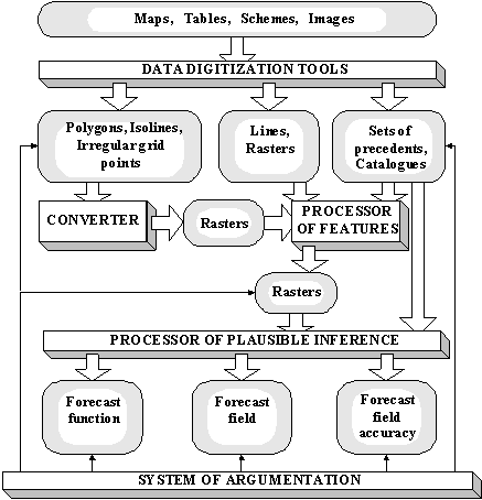
The system of argumentation helps specialist to interpret a solution, to confirm the forecast or to represent possible reasons of its inaccuracy, to make a decision about the need for model changing and to suggest a way for modification of the model. The system includes a cartography processor, module for statistic estimates of catalogues and raster fields, and cluster analysis processor. The cartography processor supports multiwindow interface with combined representation of rasters, earthquake catalogues, faults, cross sections among with a standard graphics. It has either an analyzer by precedent, which allows one to select zones similar by a set of features with a set of points under analysis. Cluster analysis processor with a set of metrics and topological correction permits to divide any zone of a region by the homogenous in geotectonic sense areas and to create a formal description of each area using a set of features.
System Geo 2.5 was successfully used for developing the maps of Mmax of expected earthquakes, for mineral, oil and gas exploration and for complex environmental zonation.
Analysis of space-time geological processes in GeoTime system.
GeoTime system has been developed mainly as a tool for earthquake prediction research [4, 5]. Input data are earthquake catalogue, time variations of geophysical parameters synchronously measured at different points of the region, and information about stationery properties of geological medium. GeoTime supports two types of data management:
Geophysical time series measured in irregular grid points and the parameters of the earthquake catalogue are transformed into dynamic fields representing three-dimensional rasters with two spatial and one temporal co-ordinates. GeoTime supports earthquake catalogue processing and computing the dynamic fields of density of earthquakes, seismic activity, b-value and fractal dimension. Spatial interpolation techniques as well as method of estimation of expected seismic source parameters are used for dynamic field generation from time series. A sufficiently extensive set-up of space-time seismotectonic oriented data processing techniques allows one to generate secondary dynamic fields for testing different hypotheses about earthquake precursors.
It is assumed that after elimination of seasonal rhythms in the absence of earthquake preparation the dynamic fields are inhomogeneous in space, but quasistationary in time. The appearance of a precursor, which occupies a certain related subset of elements of the raster, violates the stationarity of the process. Statistical hypotheses techniques are used to detect space-time non-stationarities and estimate their statistical significance.
Analysis of economic losses caused by natural catastrophes in GeoRisk system.
GeoRisk system has been designed for an estimation of direct and indirect economy losses generated by natural catastrophes [6, 7, 8]. Direct losses are determined by the cost of man made object damages. Halting of operation or utilization of the objects causes indirect losses.
To estimate the direct losses and risk the GeoRisk system generates topology, builds an intersection of seismic zonation polygons with the infrastructure polygons and calculates losses and risk for each intersection element. Afterwards loss and risk can be estimated for arbitrary objects and parts of the region. Results of GeoRisk data processing are represented as the maps of losses and maps of summarized risk for the user defined time interval.
For indirect losses and risk estimation it is supposed that in a short period of time after an impact only data about object destruction degree are available. Then we can predict what objects became inoperative and calculate the size of daily losses. The next possible task in this case is to determine an optimal rebuilding order from point of view of minimization of indirect losses. To solve this problem step by step approach is used. On the first step damaged object rebuilding of which will minimize the total daily losses is searched for. On the second step the second damaged object to rebuild next is searched for and so on.
The system was applied to estimation of loss and risk caused by seismic events in urban regions of Irkutsk, Ulan-Ude and Kuril Islands.
WWW on-line intelligent geoinformation technology: GeoNet system.
The development of intelligent network geoinformation technologies is most urgent due to with high pace of creating the information society. The main purpose of the GeoNet technology is to support a wide range of users’ demands concerning complex analysis and processing of all types of space-time geological and geophysical data with the help of virtual intelligent environment accessible through Intranet and Internet [9,10,11]. The GeoNet technology supports two types of users’ queries:
The foundation of the GeoNet technology contains two methods of reasoning constructions, which are used by specialists in geological and geophysical forecasting fuzzy logical statement construction and reasoning by analogy with precedents.
The client part of the prototype of system GeoNet is realized in Java 1.1 and is accessible on addresses http://www.iitp.ru/projects/geo, http://www.geo.web.ru/users/geotech and http://ta-www.jrc.it/gitis/index.html. Applet interactively supports the following functions of space-time data processing and analysis:
(ii) Data transformation:
(iii) Plausible reasoning of forecast maps on a complex of raster maps [7, 8]:
Bibliography
http://eos.wdcb.rssi.ru/journals/papers/9701/pap05/index.html
N.V.Kondorskaya. Schmidt United Institute of Physics of the Earth, Russian Academy of Sciences, B.Gruzinskaya, 10, Moscow 123810 GSP, Russia.
Russian scientists took active participation and presently participate in international research activities in the following directions.
Participation in general assemblies of the IGGU, Boulder, United States, 1995; the IASPEI Saloniki, Greece, in 1997; and the ESC, Tel Aviv, Israel, in 1998. Russian scientists presented reports at symposiums and working group meetings of all of the assemblies and took part in the work of IASPEI commissions and meetings on international projects.
(A) Work in IASPEI commissions. N.V. Kondorskaya participated in meetings of the Commission on Practice. In 1995, during the General Assembly of MGGS, the new working group “International Seismological Centers” with Kondorskaya as its chairman was created within the framework of IASPEI and Commission on Practice. First meeting of the working group was organized and held during the General Assembly of IASPEI in Greece in 1997. Reports of representatives of international centers in various countries were heard and the staff of the working group was approved by IASPEI:
Chairman, N.V. Kondorskaya, Russia; Vice-Chairman, J. Bonin, France; Scientific Secretary, M.N. Zhizhin, Russia; members of the group, representatives of international seismological centers: WDC-A for CEG, the United States; WDC-A for seismology, the United States; WDC-B, Russia; WDC-D, China; ISC, Great Britain; NEIC, the United States; EMSC, France; CGED, Russia; SZGRF, Germany; CEME, Russia; POSEIDON, Japan; ORFEUS, Netherlands; ESARWG, Uganda; and ESC, Russia.
Recommendations concerning the organization of a permanent discussion via Internet were adopted for the purpose of more effective exchange with data and ideas. In accordance with the recommendations, the initiative group proposed the organization of a tele-conference under the preliminary title “Virtual Seismological Observatory” (Seismological Data and Observation Practice). The United Institute of Physics of the Earth (UIPE), Russian Academy of Sciences, and WCD-B supported this idea. Detailed documents with proposals were sent to the members of the Working Group and to scientists concerned. The meeting of the Working Group is planned to be held during the General Assembly in Birmingham, Great Britain, in 1999.
(B) G.A. Sobolev and N.V. Kondorskaya took part in several meetings held within the framework of the International Seismological Project GSHAP during General Assemblies of 1995 and 1997.
Participation in the work of the International Seismological Center (ISC, international non-governmental organization). Meetings of the ISC Leading Council were held in 1995, before the General Assembly of IGGU, and in 1997, before the General Assembly of IASPEI. N.V. Kondorskaya, the constant member of the Leading Council and the national representative of the Russian Academy of Sciences in the ISC, participated in these meetings. O.E. Starovoit, the member and IASPEI representative in the ISC Executive Committee, took part in Committee meetings held in 1995, 1996, 1997, and 1998. The ISC staff includes D.A. Storchak, the UIPE staff member (laboratory 301, group headed by Kondorskaya).
Participation in the International Project GSHAP. Russian scientists took part in the works conducted within the framework of this project; these are construction of the specialized catalog of earthquakes in the “Caucasus” research area (ex. N.V. Kondorskaya) and construction of the seismic hazard map of North Eurasia (V.I. Ulomov and others). The works were conducted in cooperation with CIS scientists, and their final results were presented by Russian scientists.